
Emily Schrick

Cable Beach
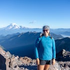
Mount Shasta, California
0.47 mi
/ 82.68 ft gain
Park at the Cable Beach parking area and walk 1/4 mile down to Lake Siskiyou for the most stunning views of Mt. Shasta.
Sunset is beautiful here: there will be alpenglow on Mt. Shasta.
This is a free parking area with a pit toilet. Overnight parking is prohibited in the lot & is signed.
This is a great spot to bring your SUP, kayak, children, and dogs. There are picnic tables down by the...

Spencer Butte Loop
Eugene, Oregon
4.5
1.6 mi
/ 564 ft gain
Getting There
Searching Spencer Butte Trailhead Parking Lot on Google Maps will direct you to exactly where you need to go. From downtown Eugene/ UO you'll drive south on Willamette St. until you see an official park sign for Spencer Butte Park. Take a left on the gated road (will be locked during closed hours - around 9 pm to 6 am), and drive up to the large parking lot. There is room for abo...

Camp at Wawona in Yosemite National Park
Mariposa County, CaliforniaWawona offers over 90 campsites in 3 loops, including 1 group site, 2 horse sites, and RV/ camper access.Every loop has at least 1 bathroom with flush toilets, but keep in mind that there are no showers at this campground.Pets are allowed, but must be kept on leash at all times.Each campground contains a fire pit, bear-proof food locker, and picnic table. This campground doesn't offer the best ...

Mesquite OHV Trail Network
Mesquite, TexasThis rugged route winds over rocky ridges, open washes, and sandy stretches, providing all with a full day of adventure.
Trail Type: Linear OHV route with multiple connecting sections.
Surface: Dirt, gravel, sand, and rock.
Difficulty: Moderate to challenging, depending on conditions and vehicle.
Best Time to Visit: Fall through spring for cooler off-roading weather.
This isn’t a polished ...

Spicer Ranch Trail System
Beatty, NevadaTrail Type: Loop options and interconnected routes.
Surface: Packed dirt and desert singletrack.
Difficulty: Beginner to intermediate, with optional progression.
Best Time to Visit: Spring and fall for cooler temps; early mornings recommended in summer.
The trails at Spicer Ranch are thoughtfully designed to balance flow and scenery, making them great for newer riders while still keeping ex...

Big Dune
Amargosa Valley, NevadaAdventure Type: Open exploration (no designated trails - managed by the BLM)
Surface: Deep sand dunes
Difficulty: Moderate to strenuous, depending on activity and conditions
Best Time to Visit: Fall through spring; cooler months offer the safest and most enjoyable conditions
Big Dune is an open playground of shifting sand, rolling hills, and steep dune faces that invite exploration in every...

Cottonwood Valley Trail Blue Diamond Loop
Blue Diamond, NevadaAdventure Type: Mountain biking (multi-trail system).Surface: Hard-packed dirt, rock, sand, and ledgy sections.
Difficulty: Beginner to intermediate options, with challenges sprinkled throughout.
Best Time to Visit: Cooler months (fall through spring) for the most comfortable riding.
The heart of the experience here is variety: flowy beginner-friendly segments and harder, rockier sections si...

Gold Butte National Monument
Gold Butte National Monument, NevadaDramatic red sandstone cliffs, twisting canyons, and endless desert vistas set the stage for an unforgettable outdoor escape. Covering nearly 300,000 acres, this remote monument blends natural beauty with deep cultural history.
Adventure Type: Multi-use desert exploration.Terrain: Sandstone formations, rocky hills, washes, and open desert.
Difficulty: Easy to strenuous, depending on activity ...

Anniversary Narrows Slot Canyon
Clark County, Nevada
4.39 mi
/ 503.94 ft gain
This short but unforgettable hike threads through tight sandstone walls and dramatic desert terrain, making it a perfect half-day outing for anyone craving a mix of exploration and quiet beauty under big desert skies.
Trail Type: Out-and-back or loop options.
Surface: Sandy washes and slickrock.
Difficulty: Easy to moderate, with narrow passages.
Best Time to Visit: Fall through spring for ...

Arrow Canyon Wilderness
Moapa, NevadaAdventure Type: Rock climbing & scrambling.
Rock Type: Red sandstone and limestone features.
Difficulty: Varies - beginner to advanced lines available.
Best Time to Visit: Fall through spring for cooler climbing conditions.
Arrow Canyon’s landscape is defined by striking red walls, canyon passages, and exposed ridges that attract climbers of many skill levels. The quality of the rock an...

Upper Pahranagat Lake Loop
Alamo, Nevada
3.11 mi
/ 79.4 ft gain
This peaceful refuge offers hikers, birdwatchers, and nature lovers a chance to slow down and soak in the quiet beauty of freshwater wetlands surrounded by stark desert hills.
Adventure Type: Walking trails, wildlife viewing, scenic exploration.
Surface: Packed dirt paths and boardwalks.
Difficulty: Easy, family-friendly routes.
Best Time to Visit: Spring and fall (for migrations and cooler...

Delamar Ghost Town
Delamar, NevadaJust off Highway 318, this impressive site offers history lovers, photographers, and curious explorers a chance to view one of the best preserved sites in Nevada.
Adventure Type: Self-guided historical exploration.
Surface: Dirt paths and rocky terrain.
Difficulty: Easy, with uneven ground in places.
Best Time to Visit: Fall through spring for moderate temperatures.
Delamar’s story begins ...

Mt. Irish Archaeological District
Alamo, Nevada
1.91 mi
/ 219.82 ft gain
Set against rugged hills and open sagebrush plains, this area invites visitors to explore ancient stone structures, walk scenic trails, and take in wide-open views that evoke centuries of desert life.
Adventure Type: Scenic walking and historical exploration.
Surface: Packed dirt paths and primitive trails.
Difficulty: Easy, family-friendly terrain.
Best Time to Visit: Spring and fall for m...

St. Thomas Ghost Town
Clark County, Nevada
2.03 mi
/ 91.21 ft gain
Once a thriving Mormon settlement in the 1860s, this quiet historic site now stands as a testament to resilience and change, where crumbling foundations and old stone walls sit amid open desert - making it a perfect stop for history buffs, explorers, and photographers alike.
Adventure Type: Self-guided historical walk.
Surface: Firm sand and compact dirt.
Difficulty: Easy, suitable for all a...

Lower Bristlecone Trail
Las Vegas, Nevada
5.94 mi
/ 942.26 ft gain
Just a scenic 1-hour drive from Las Vegas, this trail winds through groves of ancient bristlecone pines and mixed conifers - making it a favorite for hikers, runners, and bikers.
Trail Type: Out-and-back singletrack.
Surface: Packed dirt with natural mountain tread.
Difficulty: Easy to moderate, family-friendly.
Best Time to Visit: Late spring through early fall for mild mountain temps.
Th...

Kayak Mendocino's Big River
Mendocino, California
4.8
The Big River estuary in Mendocino Headlands State Park is one of those best of both worlds scenarios where dense Redwood forest and fresh, lazy river water meet rocky beaches and the mighty Pacific. If you're really lucky, you can swim with river otters and harbor seals at the same time. Paddle up the river and pull over to explore the Redwood forest - there are plenty of small trails winding ...

Pothole Dome
Wawona, California
5.0
1.01 mi
/ 220 ft gain
Getting There
From the Tuolumne Meadows Visitor Center, head west on Tioga Road/ Hwy 120 towards Tenaya Lake. You'll only travel about 1 mile down the road until you see Tuolumne Meadows open up again on your right, and there will be a very large gravel pull out where you can park. Pothole Dome will be the prominent rock rising from the meadow.
The "Hike"
Looking out at the meadow, continue...

Arastradero Preserve: Juan Batista & Meadowlark Loop
Palo Alto, California
3.0
4.65 mi
/ 597 ft gain
Getting There:
From Hwy 280, take the Page Mill Road exit and head West on Page Mill Road, away from Downtown Palo Alto (if you're taking 101, exit on Oregon Expressway). Then turn right on Arastradero Road. There will be a small sign indicating the dirt parking lot on the eastern side of the street. Note that parking is not allowed on the street.
The Hike:
There are many trails in the prese...

Andesite Peak via Hole in the Ground Trail
Soda Springs, California
4.72 mi
/ 965 ft gain
From the trail map sign, follow the dirt path straight, following signs for the cross-country skiing route, not snowmobiling. Continue until you see a trail marker. You'll veer left to head over to the Hole in the Ground trail. Once you see another identical trail map board, you'll head left. This is the official start of the Hole in the Ground trail, about 1 mile from where you parked your car...

Sugarloaf Mountain
San Mateo, California
5.0
1.64 mi
/ 417 ft gain
Sugarloaf is tucked away in Laurelwood Park which is located in a residential neighborhood right off of Hwy 92 in San Mateo, making this a great hiking & trail running option for Peninsula residents.
I always park on Glendora Dr. and follow the paved path down towards the playground. At the bottom of the hill you'll see a trailhead sign with some options for proceeding up the mountain. Tho...
Discover
Community
Mobile Apps

© 2026 The Outbound Collective - Terms of Use - Privacy Policy