
Emily Schrick
5.0
5.0
5.0
Great short hike. Parking area is the dispersed camping area with the fire rings. Big open space but kind of confusing because theres no real “lot”. Youll hike up the trail that looks like the road continues on. Only 1.75 miles round trip and easy. The falls are super pretty.
4.0
This place is pretty but gets crowded. Still beautiful though. The main pool beneath the waterfall is great for swimming in. Lots of parents and families and groups. You have to scramble down to the water from the ADA path - be careful because it gets slippery and saw a kid take a pretty hard fall. Theres a picnic table underneath trees next to the ADA path near the spot to go down to the waterfall.
4.0
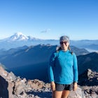
I only hiked to Cutthroat Lake, which is about 3.75 miles round trip with 500 ft elevation gain total. Its a super mild trail - great for families or beginner hikers. Great views of the mountains and so many larches at the lake!
4.0
Great spot for larch hiking & fall colors! Definitely steep so pace yourself. Views begin about halfway up and get better and better! Make sure you hike a little past the pass to look down into the valley below - its beautiful!
5.0
Id highly recommend this PCT section! I thru-hiked the trail in 2018 and I really enjoyed this part, rven though i was flying through and only spent 2 nights in the section. Parking at Echo Lakes is somewhat challenging for those looking to section hike - its pretty popular, but the upper lot in the woods is yoir best bet. You can take the water taxi across the lake if youd like, but i enjoyed hiking above the little cabins along the lakeshoe. The trail tread is very rocky here so just be aware - no need to twist your ankles early on. My favorite parts of this section were Desolation Wilderness - especially Lake Aloha and Fontanillis Lake, and Dicks Pass. The views of Lake Tahoe after Barker Pass are also really nice and hiking through Alpine & Palisades was fun. Its cool watching the landscape change in this section from alpine lakes to mountain ridgelines. The portion of trail before I-80 is so expansive and you almost feel like you’re on top of the world! I camped at Lake Aloha & a spot just beyond Barker Pass. Sadly I dont remember how the camping was in this area but i do remember a lack of water after the desolation wilderness so make sure to top up!
5.0
Gilmore Lake sits underneath Mt. Tallac and is a great beginner backpacking trip! The trail is pretty rocky, so be aware if you have dogs - protect their paw pads well! After a heavy snow year (2023) there were still patches of snow at the lake in mid-July, but the rest of the trail was clear. There is a trail up Mt. Tallac from Gilmore Lake - great to add on to your backpacking trip!
4.0
Heads up! Bayview campground has been converted to day use only. Its a large parking lot and picnic area with a couple of pit toilets. Cost is $12 to park. Trailhead access to cascade falls and desolation wilderness & maggies peak.
1.0
Black Mountain is great & the views are nice on this trail once you reach the Quarry Trail. On the PG & E trail (aka stephen e. Arbors trail) you are walking underneath power lines enough that you can heard them buzzing. This is a very wide trail - more like a road and quarry is singletrack. Great training hike though
3.0
$5 day use fee or free with an interagency pass (like america the beautiful). Really nice hike through grasses and wildflowers are blooming right now! Takes you down to a footbridge where the trail continues. Theres a pg&e station visible above the gorge. Still nice views. Trailhead has pit toilets and a water spigot. Read the trailhead board - talks about water releases upstream from the dam - safety info. Campground at this trailhead as well run by the BLM. $10/night. Walk in tent sites only.
4.0
This is a very cool historic site in Petrified Forest! You get to see the remnants of a native living quarters and petroglyphs in the rock. Stay on trail to protect the integrity of this place!
5.0
Great snowshoe hike for beginners. The area is groomed by the Nevada Nordic team, so if you are using the groomed trails, make sure you dont cross the xc ski tracks. Dog friendly! Just pick up after your dog. Theres dog bags and a trash bin at the trailhead near the road. Such agreat views especially at sunset!!
5.0
Gorgeous views of the river. Its just a shame that there are so many irresponsible dog owners who dont pick up their dogs poop! Its everywhere on the sides of the trail.
3.0
Very small parking lot. This is a short standalone loop. Visiting china cove and bird island. Saw tons of seals & birds here today!
5.0
Need to park at sea lion/ cypress grove parking. I wouldnt do this hike alone in the park. Pair it with cypress grove, sea lion point, and china cove and bird island loop.
4.0
This trail starts near the main pay booth and bathrooms in the preserve, and the beginning of the full park loop if you want to walk in a clockwise loop. You walk through a bit of forest with some ups and downs and it parallels the highway for a bit. Youll pass a trail on your right, keep walking straight. Once you get to the cliffs, youll stay left to do the bird island loop. We saw tons of pelicans, gulls, and cormorants here. Make sure you hike to the left after doing the loop and climb up a way so you can see the beach at China Cove - every time I’ve been here, there are always elephant seals on the beach!
5.0
Probably the most popular section of Point Lobos Preserve. Parking lot is very small but there are portapottys and flush toilets in the lot. Varying levels of tidiness but it is a holiday week. Truly amazing views on this hike. Ive been here 3 times over the years and the view never gets old!
5.0
This is my top quick hike to bring my dogs on! Its located in Pulgas Ridge open space preserve and this loop is off-leash dog friendly once you are in the signed, fenced area. There are bathrooms in the small parking lot and doggy poop pick up bags and trash cans at the trailheads. Please remember to take your dog’s waste with you and throw it away!
4.0
Starting from the parking lot on portola rd. and heading up the Spring Ridge trail via the Betsy Crowder trail to Windy Hill is such a great workout, and offers great views of the rolling hills of the preserve. Going after a rain is the best - all of the grass is green, but be careful if descending via the Hamms gulch or lost trail - they'll be muddy & slippery!
4.0
Following the powerful Tuolumne River for a good amount of this hike is awe-inspiring (especially after this winter). The waterfalls were raging and you could feel the power of the river standing on the footbridges. We had to camp away from the backpacker's camp since the footbridge was washed away, but this spot would make an awesome camp spot if you wade across or wait until the bridge is fixed!
5.0
Added a Cloud's Rest detour to our high sierra backpacking loop this summer, and it was easily one of the best days on trail! I couldn't wait for the view at the summit, but the actual hike is simply gorgeous as well! Of course, the views from the top were just amazing. Seeing Half Dome from a unique angle, catching a glimpse of Tenaya Lake in the distance, looking at the mountains we had been hiking through from way above. Just incredible. There are lots of camping spots once you get above the treeline. We camped about 3/4 mile south of the summit in a huge flat spot off the trail - and were even blessed with a black bear sighting the next morning. Couldn't recommend this more as a day hike or backpack.
5.0
We backpacked in to May Lake from Glen Aulin at the end of July, and there was still tons of snow around the lake, on Mount Hoffmann, and half of the lake was still frozen! So beautiful. And we saw a few marmots scurrying around :) This place can get crowded though! There were lots of backpacking groups, I can't even imagine how busy this place would be if the high sierra camps were open! But that's to be expected since its so close to Tioga Road.
4.0
Discover
Community
Mobile Apps

© 2026 The Outbound Collective - Terms of Use - Privacy Policy