
Mt. Washburn via South Trail
Yellowstone National Park, Wyoming
Details
Distance
7.02 miles
Elevation Gain
1680 ft
Route Type
Out-and-Back
Description
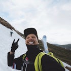
Added by Ben Lertsakdadet
Mt. Washburn via South Trail starts from Dunraven Pass. This is the highest point of Yellowstone National Park with 360° Panoramic view of the park.
The parking lot for the Mt. Washburn Hike from Dunraven Pass trailhead is located about 5 miles north of Canyon Village along the Grand Loop Road. Since we wanted to reach the top of Mt. Washburn before sunrise, we began our hike 2 hours earlier. If you decide to attempt a sunrise hike, I highly recommend carrying either a flashlight, or even better, using a headlamp, and having bear spray readily available as this area is known for having black bears and grizzlies.
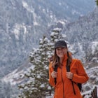
The trail begins with a steep ascent straight out of the parking lot and wraps along the side of the mountain. About 1.5 miles into the trail, you will reach the beginning of a series of switchbacks that will extend for a mile. Once you reach the end of the switchbacks, the trail flattens out a little bit as you walk along a ½ mile stretch with drop-offs on both sides. As you get closer to the lookout tower, the trail will merge with Chittendon Road, so keep left.
The hike up took us about 1 and ½ hours, which should have given us plenty of time to relax before sunrise. Unfortunately, the weather can change in an instant in Yellowstone, and the thunderstorms came in much earlier than was forecasted, so we spent most of the morning taking photos in the rain. From that experience, I would not recommend hiking Mt. Washburn if rain is in the forecast at all for the day of your hike, unless you are comfortable with getting your camera gear wet.
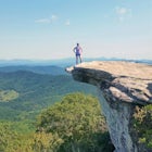
For anyone visiting Yellowstone, this trail is a must and should be at the top of your list. The lookout tower at the peak of Mt. Washburn is the highest point in Yellowstone National Park and gives you a 360° view, which allows you to see for miles through the valleys on a clear day.
Download Outbound mobile app
Find adventures and camping on the go, share photos, use GPX tracks, and download maps for offline use.
Get the appFeatures
Mt. Washburn via South Trail Reviews

One of the first hikes I did in Yellowstone and it was a fun one! When I went there was still some snow and ice on the ground but overall very pleasant day.
5.0

Started early in the morning. Started at Dunraven parking area. Spotted some animals feeding on the terrain. Would recommend this hike
5.0
We did this as a day hike, started around sunrise. The hike is pretty easy, and is a very wide road-like trail. This was my favorite part of my trip to Yellowstone. The geo-features are sweet, but this hike was incredible, and not too difficult.
5.0
Located near the middle of the park, this hike allows you to see 360 views of the entire park and the Tetons 75 miles away in the distance. In mid-June there was still snow covering parts of the trail near the top, but the snow is compacted and easily passable due to the amount of traffic on the trail. The wind at the top is relentless and it will be cold at the summit regardless of how warm it is at the base of the mountain. Arrive early because the trailhead lot can fill up quickly. Carry bear spray.
4.0
This was a great hike in Yellowstone. But like the write-up says, the weather can change rather quickly, so be prepared! When I began the hike, the skies were blue and the sun was out. By the time I reached the summit, a storm had rolled through. And then about halfway down the hike, the sun was out again! Regardless, it was still a great hike with beautiful views along the entire trail!
4.0
This is a great hike and the views cannot be beat in Yellowstone. You can even see all the way to the Tetons. The trail is well maintained and when we hiked it in the afternoon we ran across lots of Big Horn. We did this in the middle of summer over 4th of July week and the park was crazy. As soon as we headed off on the trail, we had so much space as most visitors to the park do not leave the roads. We passed about 8 groups throughout the whole hike. Definitely agree about having bear spray easily accessible. This is grizzly country. I highly recommend this hike. Even though it was early July, it was very cold at the top. Wear lots of layers - we looked like we were dressed for winter.
5.0
Leave No Trace
Always practice Leave No Trace ethics on your adventures and follow local regulations. Please explore responsibly!
Nearby

Cascade Lake Trail

Artist Point

Brink of Lower Falls via North Rim Trail

Red Rock Point

Brink of the Lower Falls Trail

Hike Uncle Tom's Trail
Discover
Community
Mobile Apps

© 2026 The Outbound Collective - Terms of Use - Privacy Policy