
Part I: Exploring the Blue Ridge Parkway near Asheville - North
Top spots to check out along one of the most beautiful roads in the southeast.
This is the first of a two-part series about exploring the Blue Ridge Parkway near Asheville, North Carolina. In this first segment, I’m going to take you to some of my favorite spots heading north out of town along one of the prettiest stretches of road not only in the southeast, but arguably, the United States.
For starters, the Blue Ridge Parkway is a 469 mile stretch of road that connects Shenandoah National Park in Virginia to Great Smoky Mountains National Park in North Carolina. Technically, mile marker 0 is in Virginia and mile marker 469 is in North Carolina, but you can explore in any direction you choose. Locals refer to it as just ‘The Parkway’ and often use mile markers to refer to their favorite spots. You’ll find numerous spots that don’t receive a cell phone signal along the Parkway, so knowing what mile you are on will be helpful information to have along the way.
Oh, and the best part? It’s free. There are no tolls or entrance fees.
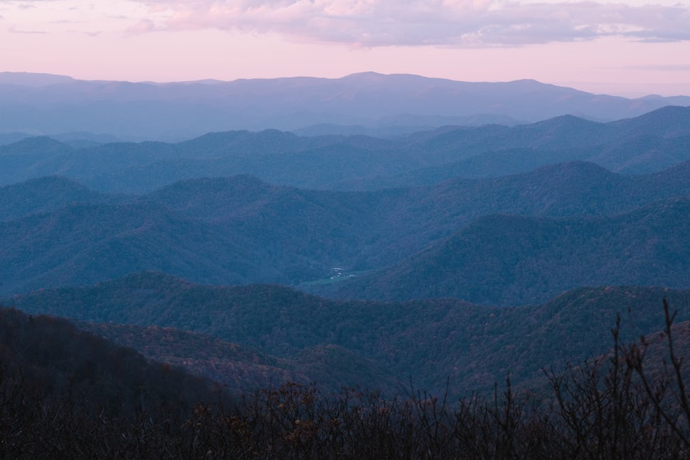
Blue Ridge Parkway Visitor Center - Asheville | MM 384.5
There are 17 Visitor Centers along the Parkway, many of which are seasonal. The Asheville Visitor Center, however, is open daily from 10am to 4pm except for Thanksgiving, Christmas, and New Year’s. If it’s your first time to the area, it’s a good place to start your adventure. You can pick up a map, fill your water bottles, check out some of the exhibits including a 24-minute movie about the Parkway, and chat with a ranger about some of their favorite hikes and overlooks.
My favorite thing about this Visitor Center, however, isn’t what’s inside, it’s the green, living roof.
Folk Art Center | MM 382.2

Just a few miles up the road from the Asheville Visitor Center is the Folk Art Center. Inside you’ll find all kinds of art from local makers and crafters. There’s a lot of cool stuff to look at in there, everything from jewelry to quilts to carvings and cards, and much of it is for sale.
Most of the time I come here, though, isn’t for the art - it’s to link up with friends. The Folk Art Center has a really big parking lot, which is great for anyone towing a trailer or driving a big RV. It’s also well marked, so there’s very little chance of not being able to find your buddies.
Bonus: You can still get a cell phone signal in case you need to do a little last minute trip research.
Haw Creek Valley Overlook | MM 380

A lot of people just refer Haw Creek Valley Overlook as the ‘sunset spot’. It’s pretty close to town (just over 8 miles from downtown), and well, you can get a good view of the sunset. A lot of people will sit in the cars and watch the sun go down, but just as many will set up lawn chairs and blankets. I’ve even seen a few people with guitars here. It’s a pretty social spot. Even if you have no desire to stop at this overlook, be sure to check your speed as there are always a bunch of people that spill out of their cars and onto the road, eager for a photo. The elevation is only 2720 feet and the view is just ‘so-so’, but if you don’t want to drive a ton out of town, it’s still better than nothing.
Lane Pinnacle Overlook | MM 372.1

From the Haw Creek Valley Overlook, if you continue north 7.9 miles, you’ll eventually reach the Lane Pinnacle Overlook. In those miles, you’ll have gained about 1,100 feet in elevation and a much prettier view, one that isn't marred by a ton of buildings. This is probably one of my favorite overlooks near Asheville. And unlike the Haw Creek Valley Overlook which faces west, Lane Pinnacle Overlook faces east.
Photographers may like this one even better as you don’t have to shoot directly into the sun, but can instead reap the benefits of golden hour as the light dances upon the mountains at sunset. (For a sunrise drive, flip the two locations mentioned above for the best photos).
Craggy Gardens Visitor Center | MM 364.4

Another visitor center? Yep.
I like stopping here for three reasons: the view is amazing, I usually need a bathroom break after all the coffee I’ve had driving up here and they have public restrooms, and, maybe most importantly, there is a really beautiful trail nearby, the Craggy Gardens Trail.
You can pick this trail up by heading to the southernmost part of the parking lot. Look for a sign near the rock wall and then take a few stone stairs down to the trail that will lead you through some beautiful rhododendrons, and in less than a mile, to the Craggy Gardens Picnic area. From there, you can continue on along the iconic Mountains to Sea Trail (and catch a sunset on Green Knob) or you can head back to your vehicle and check out another one of my favorite hikes, Craggy Pinnacle Trail.
Craggy Pinnacle Trail | MM 364.1

I’ll always have a soft spot for this place because it's one of the first places I found a real connection to near Asheville.
This hike gets super busy because it’s short (it’s about .7 miles up to the top or 1.4 miles roundtrip) and it’s gorgeous. When friends come to town and they say they want to hike (but not a ton) and they want to get an amazing photo (without a lot of effort), this is where I send them.
Craggy Pinnacle Trail isn't a big secret, but it’s one of those places that you have to see in person. The parking lot is fairly large and on a busy day you may have to make the loop a few times to find a spot. It’s worth the effort though. The views from Craggy Pinnacle, at 5,892 feet, are stunning.
The weather is fickle, so bring a layer -- even in the summer. I’ve been up there on days when it’s sunny and bright, but then five minutes later a cloud comes through and it’s cold and damp and there’s zero visibility and then five minutes later its back to being sunny with a view for miles.
Mount Mitchell State Park | MM 355.4

It’s just under 29 miles from downtown Asheville to Mount Mitchell State Park. If you drive there without making any stops, you can probably get there in just under an hour. Just don’t forget that the point of the Parkway isn’t to see how fast you can cover ground but to notice your surroundings, pull over at overlooks, get out of your car, take photos, and take part in nature!
Still, I could easily make a case for driving directly to Mount Mitchell and spending an entire day there. It’s one of my favorite spots in the area.
Its claim to fame is that it is the highest point east of the Mississippi at 6,684 feet. Definitely snap a photo of yourself next to the sign at the summit (the trail is steep and paved and only .15 miles long) and then get away from the crowds and into the woods along one of the other trails.
The Balsam Nature Trail is a good pick for first-timers because it has some signs along the way that can help you learn about the environment around you but it’s only ¾ of a mile long. The Mount Mitchell Trail and Deep Gap Trail are both good options for those wanting a longer hike.
As you might expect, the weather up here at Mount Mitchell is often very different than the weather in town or even nearby Burnsville, NC. Be sure to check the weather prior to leaving and pack several layers.
Green Knob Fire Tower | MM 350.4

You can see this fire tower from the Parkway. It looks like a cool tiny house on stilts. Unfortunately, it’s closed off to the public. It still makes for a cool photo op and a nice hike if you’re tired of being in the car and need to stretch your legs.
Park at the Green Knob overlook and then continue on foot, north, for about a hundred yards. The trailhead will be on your left. The hike to the base of the tower is a winding stretch of semi-technical switchbacks that climb up for about a half a mile. Follow the white blazes and when the trail forks near the summit, bear left.
Additional tips for exploring the Blue Ridge Parkway
Watch for cyclists and please share the road.
Be mindful of your speed limit. In most sections, the speed limit is 45 but it does drop to 25 in many areas. Watching your speed protects both pedestrians and wildlife.
If you're driving an RV, be sure to check the park's website to make sure that it isn't too tall and that it will make it through the tunnels!
Check to be sure the parkway is open via the National Park Services real-time status map. Sections of it will close due to ice and sometimes rockfall.
Your cell phone won’t work in many areas of the park, so be sure to do your research before you leave.
There are very few places along the Parkway to get snacks, so pack a cooler before you go. Mount Mitchell has a concession stand that’s open seasonally (late May to mid November).
We want to acknowledge and thank the past, present, and future generations of all Native Nations and Indigenous Peoples whose ancestral lands we travel, explore, and play on. Always practice Leave No Trace ethics on your adventures and follow local regulations. Please explore responsibly!
Do you love the outdoors?
Yep, us too. That's why we send you the best local adventures, stories, and expert advice, right to your inbox.


