
Blue Lakes Trail
Telluride, Colorado
Details
Distance
8.81 miles
Elevation Gain
2635 ft
Route Type
Out-and-Back
Description
Added by Outbound
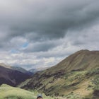
Colorado’s San Juan Range is full of craggy peaks, lush wildflowers, and gorgeous alpine lakes, and in mid-summer, you’ll find them all on a hike to the three Blue Lakes. And if you like to fish at your hiking destinations, you're in luck; all three lakes are good for fishing, too.
Your adventure begins at the Blue Lakes Trailhead, elevation 9400’, in Uncompahgre National Forest. Take CO-62 from Ridgway toward Telluride, turn left onto Ouray County Road 7, and follow it into the national forest to the end of the road. Just past the trailhead, the trail splits; be sure to take the right fork toward Blue Lakes. (The left fork goes to Blaine Basin.) The trail climbs steadily into the Mount Sneffels Wilderness and brings you to Lower Blue Lake, elevation 10,980’, after ~3.3 miles. In mid-summer, you might see some wildflowers along the way, but be patient; the best is yet to come. Just before you reach the lake, you should see a sign on your left indicating the continuation of the trail to the left; Lower Blue Lake itself is to the right at this junction. Arguably, the best camping can be found along this lake, as it is the only one of the three below tree-line; there are lots of good campsites on the near side of the lake.
To reach the middle and upper lakes, go back a few steps to the junction and head right across the outlet of Lower Blue Lake and up a steep slope that climbs 500’ in about half a mile to Middle Blue Lake, 11,500’. As you climb, you’ll notice the deep blue color of the lower lake. You’ll pass tree-line on the way to Middle Blue Lake; be aware that there is no more shelter to be had from this point on in case of thunderstorms, which roll up frequently and quickly in late July and August. From the middle lake, it’s just another quarter mile or so to Upper Blue Lake, 11,700’. During peak wildflower season, the banks of all three lakes are covered in wildflowers; you’ll find lots of columbine and paintbrush near the middle and upper lakes. At Upper Blue Lake, the trail continues another 1.5 mi and up 1300’ to Blue Lakes Pass at about 13,000’; from the pass, you can reach the summit of Mount Sneffels via the southwest ridge or by descending the other side of the pass and joining the standard route up Lavender Col.
It’s worth repeating that in mid-summer, you should pay close attention to the weather, especially if you intend to set up a base camp for a climb of Mount Sneffels; thunderstorms in this basin can be violent and deadly. With proper caution and some common sense, though, this is one of the most memorable landscapes in a state full of mountain splendor. Happy adventuring!
Download Outbound mobile app
Find adventures and camping on the go, share photos, use GPX tracks, and download maps for offline use.
Get the appFeatures
Blue Lakes Trail Reviews

Challenging hike with a stunning turquoise lake as your reward. Totally worth the burn! It is steep! The road to the trail head is long. There is some free camping near the trailhead.
5.0
Stretched this hike into a 3 day backpacking trip in late September. Seriously some of the most amazing views I've ever seen.
5.0
I hiked the Blue Lakes Trail last summer with two of my best friends on our annual 'Best Friend Weekend' - I'm so lucky to have people who enjoy getting outside as much as I do (But really, could I even be best friends with someone who doesn't? Unlikely.). We didn't camp at the trail head, although that's certainly an option, we stayed in Ouray at the Amphitheater Campground so we could spend on post-hike evening at the hot springs in town :) We ventured out on the last weekend in July and were greeted with peak wildflower season, which was a treat. We also saw a bear frolicking through a meadow of wildflowers, oblivious to the many hikers stopping on the over-looking switchbacks to snap pics. Every time I look back at pictures from this trip, they almost look fake even though I was there and got to see the beauty with my own eyes, it's hard to believe a place this amazing exists. This was by far the most beautiful hike I have ever been on in my life; although I will constantly strive to top it from now on because clearly that's a good goal to have.
5.0

Great hike with awesome views. The lower lake is the most picturesque, in my opinion, but the upper lakes are definitely worth the extra effort.
5.0
What a hike. Took us about 5 hours from the trailhead to upper lake and back. Wildflowers, waterfalls, creeks, mountains, and lakes! What more could you want?! The views were unbelievable. Do note that it can get chilly and windy at middle and upper lake. Definitely bring a jacket/sweater!
5.0
Leave No Trace
Always practice Leave No Trace ethics on your adventures and follow local regulations. Please explore responsibly!
Nearby

Mount Sneffels via Yankee Boy Basin

Climb Mt. Sneffels via the Southwest Ridge

Twin Falls in Yankee Boy Basin

Photograph Dallas Divide

Hike the Jud Wiebe Trail

Hike to Cornet Creek Falls
Discover
Community
Mobile Apps

© 2026 The Outbound Collective - Terms of Use - Privacy Policy