
Summit The Golden Hinde
Comox-Strathcona D, British Columbia
Details
Distance
40.4 miles
Elevation Gain
5987.5 ft
Route Type
Out-and-Back
Description
Added by Rumon Carter
Tackle Vancouver Island's highest peak (2200 m / 7,219'). The total gain for the round trip will get your legs feeling it as you'll gain approximately 4,368m.
As Vancouver Island's highest peak, the Golden Hinde is an obvious draw for coastal climbers. Its gravitational pull, however, requires a commitment, given this crown jewel of the Island Alpine is also one of its most remote, and gains more elevation than from Base Camp to Everest's summit.
Winter ski-in ascents are possible, though rarely undertaken. The Hinde is most often and most conservatively ascended during the heart of summer. This description details the most common route used to climb the Golden Hinde, from the trailhead just beyond the Westmin Mine at the south end of Buttle Lake, up to and along Phillips Ridge, before gaining the summit via the SE couloir hiker's route (Class 4 scrambling). For more detailed descriptions please see Phil Stone's "Island Alpine," (p. 271), which includes alternative routes via the Elk River and Marble Meadows, (see another of my posts for route description) as well as the non-hiking (Class 5+) routes to the Hinde summit.
For the standard route, trailhead access is found at the end of the Buttle Lake Parkway, reached via Highway 28, west of Campbell River. After driving around the south end of Buttle Lake and through the odd, slightly apocalyptic scene of the Westmin Copper Mine that exists within the park, you will see the trailhead access clearly marked.
Well-graded, moderately sloping, but relentless switchbacks take you up to the first of 4 major lakes along the route, Arnica. Excellent camping is available at a couple of points around the lake. From here, the route continues to meander up to treeline and your first views of the Hinde in the distance. Phillips Ridge is gained shortly thereafter, and in clear weather you will have the Hinde as your companion throughout as you follow the rising and falling of the ridge.
The route descends from Phillips Ridge to the far end of Carter Lake, which has more excellent camping, before a short climb and descent take you to the larger Schjelderup Lake. The route along the lookers-left shore of Schjelderup Lake is the most deceiving part of the route - plan for a good stretch of time navigating boulders before some root-grabbing forest scrambling takes you to the far end of the lake. There's good camping here, though you may want to consider hiking a little farther to set up on Burman Ridge for commanding views of the 1000m final climb of the Hinde (take water if you do - there's none on the ridge).
Either way, from Burman Ridge you need to descend to Burman Lake before beginning the final climb. You will pass through to a wooded section fairly quickly, which is very hot in the heat of summer, before reaching a gorgeous tarn at the base of the mountain's south face. Refill your water here. If you are taking the SE couloir hiker's route, skirt around the tarn and onto that aspect.
After 500m more of rocky scrambling you will be at the top of Vancouver Island's world, with 360-degree views of the surrounding Strathcona Provincial Park, in its glory, as well as the Pacific Ocean to your west, the Georgia Strait and Coast Range to your east, and Cascade Range to your southeast.
The photos above document a 16-hour single-day push by the explorer and running/climbing partner, Jamie Sparling, in early August 2014.
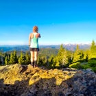
The summit photo shows the route along Phillips Ridge, past Carter Lake and Schjelderup Lake (located around the center of the photo), onto the Burman Ridge and past Burman Lake (by my left shoulder). The ridge towards photo left is the access from Marble Meadows.
Another photo shows Jamie trying to punch through one of the couloirs on the south face - to save some time we climbed the scree slope directly above the tarn and then traversed eastward, ascending a low class 5 couloir (not pictured) to the west of the SE route.
The last photo is our parting view of the peak before dropping off Phillips Ridge to finish our 16-hour run in the dark.
Download Outbound mobile app
Find adventures and camping on the go, share photos, use GPX tracks, and download maps for offline use.
Get the appFeatures
Summit The Golden Hinde Reviews
Great summary of this magical journey to the peak of Van Isle, Rumon. I also had the gift of travelling this same path on a 3-day solo walk about last September. I just ran back up to Phillips Ridge yesterday to get another view of Mr. Hinde! Such a looker;). Snow is nearly melted out of the SE gully as we speak. My tale from the trail: http://elmhealth.blogspot.ca/2014/09/hinde-sight.html Happy Trails SS
5.0
Leave No Trace
Always practice Leave No Trace ethics on your adventures and follow local regulations. Please explore responsibly!
Nearby

Camp at Arnica Lake

Mt. Myra via Tennent Lake Trail

Exploring Myra Falls

Hike to Flower Ridge

Climb Mt. Septimus via the X-Gully

Hike to Baby Bedwell & Bedwell Lake
Discover
Community
Mobile Apps

© 2026 The Outbound Collective - Terms of Use - Privacy Policy