Bighorn No. 8, Alberta
Looking for the best hiking in Bighorn No. 8? We've got you covered with the top trails, trips, hiking, backpacking, camping and more around Bighorn No. 8. The detailed guides, photos, and reviews are all submitted by the Outbound community.
Top Hiking Spots in and near Bighorn No. 8
-
Banff, Alberta
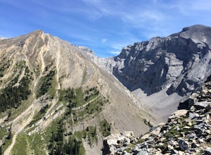
Hike Cascade Mountain, Banff NP
7.5 mi / 4800 ft gainFrom Banff, follow the Norquay Road (the west access road to Banff) up to Mt. Norquay Ski Area. The trail begins from the day lodge at the far end of the first parking lot on the right.Walk by the front of the day lodge and follow a service roaddown through the ski area past the base of three cha...Read more -
Banff, Alberta
Hike Tunnel Mountain, Banff
4.02.7 mi / 984.3 ft gainThe lower trailhead is only a short walk from Downtown Banff. Head east on Wolf street and up St. Julien Road and you will see the trailhead shortly after passing Wolverine street.There is also a upper trailhead on Tunnel Mountain Drive across from the carpark and viewpoint. Although this is clos...Read more -
Canmore, Alberta
Hike Grotto Mountain
7.5 mi / 4429.1 ft gainFrom Highway 1A take the exit to the Alpine Club of Canada. Park near the woodpile as the actual parking lot is for Alpine Club customers. The trailhead about 30 metres up the road from the woodpile.The start of the trail is fairly relaxed but it quickly becomes a steep uphill battle. There are t...Read more -
Banff, Alberta
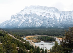
Hike to the Hoodoos, Banff
5.03 mi / 295.3 ft gainThe beginning of this hike is easily accessed from the town center of Banff by the Bow river. Perfect for those without a car! Follow the trail on the side closest to town as it leads up the Bow River and into the forest following the signs for Hoodoos Loop.The hike is 4.8km one way, leading arou...Read more -
Bighorn No. 8, Alberta
Heart Mountain and Grant MacEwan Scramble
2.0A bit of a jaunt is required to get to the start of the scramble - follow the Heart Creek Trail, and after crossing the creek, look for a yellow sign that marks the scramble route. There will be exposure as well as use of hands, but it is totally do-able as long as you keep your head right!After ...Read more -
Bighorn No. 8, Alberta
Hike through McGillivray Canyon
1.0Between Pigeon Mountain and Mount McGilliveray, pull off the road and slow down until you see a little dirt road turn off to the large parking area.Follow the trail heading south- don't take the transcanada trail- further up you will find another small trail that takes you to the creek bed. Follo...Read more -
Canmore, Alberta
Hike to Grassi Lake
4.52.4 mi / 820.2 ft gainTo get to the Grassi Lake trailhead, continue past the Nordic Center about 2km and take a small left when you reach a junction between a gravel road and a paved road. You want to be on the paved road, as this will lead you down to the Grassi Lake parking lot. The trail starts right behind the res...Read more -
Banff, Alberta
Dawn to Dusk in Banff National Park
5.06.8 miThis is a micro adventure in one of the world’s most desired National Parks. The common excuse for those who tend to skip the great outdoors is lack of time. This one day adventure is an example that you can cram a lot into a day! Dawn: Sunrise hike up to South Ridge in Banff. Start at the famous...Read more -
Kananaskis, Alberta
Hike the Prairie View - Jewel Pass Loop
5.09.3 mi / 2050.5 ft gainPark at the Barrier Lake day use area on Hwy. 40. Make your way across the dam heading west. Follow the main trail slightly north west into the trees and begin your ascent. Mostly long switchbacks with some sections getting a bit steeper near the top. As soon as you break through the trees, you'l...Read more -
Kananaskis, Alberta
HIke to Barrier Lake Lookout
3.3From the parking lot, cross the dam, heading west onto the trail, with the lake on your left. Once you reach the forest, you will come to a 'Y' intersection, from which point you have two options:6.7 miles (10.8 km), 4 hours roundtrip, out-and-back For a shorter hike, go right at the 'Y' intersec...Read more -
Kananaskis, Alberta
East End of Rundle Scramble
4.44.7 mi / 2880 ft gainThis well marked, fun hike that has a bit of everything, from easy forest walking, to steep slabs, minor hands on scrambling, and a scree slope to the summit.From the parking lot, head north up the hill, where the trail begins around the power poles. There a few different paths to start, so it's ...Read more -
Canmore, Alberta
Ha Ling Sunrise Hike
4.15 mi / 2296.6 ft gainStart at the Goat Creek parking lot and cross the road towards Ha Ling. There is an access road with a gate on the other side. Walk up the road and across the bridge. From there the trail is obvious and will lead you to the summit. Overall it's a fairly easy hike with switchbacksOnce above tree l...Read more -
Canmore, Alberta
Hike Pigeon Mountain
Important note: trail closure from December 1 - June 15th.Altitude: 2,394m (7,852 ft)Elevation gain: 990m (3,247 ft)Round trip: 6-6.5 hours (15 kms)Heading West from Calgary on Trans Canada Highway #1 - take the Dead Mans Flats overpass, and go South for 1 -1.5 kms until you reach a parking lot. ...Read more -
Improvement District No. 9, Alberta
Hike the Cory & Edith Pass Trail
4.09.3 mi / 3002 ft gainGoing west from Banff, take the first exit for Highway 1A (Bow Valley Parkway). Take the first right up to the fireside picnic area and begin your hike here. The first 5kms of the hike climb uphill through the forest, making up most of the 915m elevation gain. Watch for trail markers over the ro...Read more -
Canmore, Alberta
Trail Run on the Wind Ridge-Bow Valley
8.4 miWind Ridge is a 7,217 ft / 2,200 m mountain peak near Canmore, Alberta, Canada, with spectacular views into the Bow Valley. The trail is primarily used for hiking and is accessible from May until November.Take the Spray Lakes Road from the town of Canmore for 22km. The trail head is just below th...Read more -
Kananaskis, Alberta
Hike Alberta's Mount Baldy
4.0Rated as moderate to difficult due to scrambling sections. Estimated round trip is 4-5 hours depending on experience. From highway #1, the trailhead is located 13 kms South on highway 40. You will spot a small stream on your left with a small parking area for a few cars. The trail head is often m...Read more

