Black Diamond, Washington
Looking for the best hiking in Black Diamond? We've got you covered with the top trails, trips, hiking, backpacking, camping and more around Black Diamond. The detailed guides, photos, and reviews are all submitted by the Outbound community.
Top Hiking Spots in and near Black Diamond
-
Lewis County, Washington
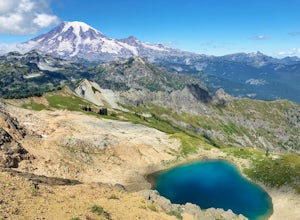
Hike Indian Bar - Cowlitz Divide via Box Canyon
14.64 mi / 4235 ft gainThere are multiple ways to access Indian Bar. This one starts at Box Canyon. From the parking area at Box Canyon walk across the road and follow the signs for Wonderland Trail. Head up the Wonderland trail through the trees to the split with the Cowlitz trail. Continue on the Wonderland Trail...Read more -
Gold Bar, Washington
Wallace Falls
4.65.01 mi / 1404 ft gainThe trailhead is located at the far end of the parking lot, next to the info kiosk and bathrooms. It starts out in a wide-open area that shortly leads to stunning views of Mt. Index and Baring Mountain. The trail turns to the left and you're greeted by a beautiful Wordsworth quote carved into a t...Read more -
Gold Bar, Washington
Hike to Wallace Lake via Greg Ball Trail
4.58.2 mi / 1500 ft gainAn alluring State Park for its massive waterfall display, Wallace Falls is a high traffic destination along Highway 2, but don't overlook Wallace Lake as the falls steal the limelight. Head East on Highway 2, once you enter the town of Gold Bar keep on the lookout for the State Park signs and tu...Read more -
Skykomish, Washington
Jade Lake via the Necklace Valley Trail
15.26 mi / 3323 ft gainThis hike is definitely one of our all-time favorites. The first time we did it was in August 2015 and due to the exceptionally mild winter that year, fall was already beginning to show its colors. We wanted to see it again in the springtime when everything was in bloom, so we decided to go again...Read more -
Skykomish, Washington
Tank Lakes via Necklace Valley
18.94 mi / 4721 ft gainTucked high in the heart of the Alpine Lakes Wilderness, Tank Lakes has everything you could ask for out of a Washington hike. You start low at the Necklace Valley trailhead just south of Skykomish along Highway 2 and meander five miles to a giant log crossing of the East Fork Foss River. From h...Read more -
Ronald, Washington
Camping at French Cabin Creek Rd.
3.0This area is a very secluded camp area, so unless it's a holiday weekend, be prepared to be alone :) It is a very quiet lake and along the roadside there are plenty of spots to hike, camp, and fish by the lake or the Cle Elum river.So bring your day hiking gear and pole as well and head out in th...Read more -
Gold Bar, Washington
Barclay Lake
4.44.4 mi / 607 ft gainWith less than 500 feet of total elevation and 4.4 miles of round trip hiking, the Barclay Lake trail is a perfect hike for beginners, families, or those looking for a quick morning or afternoon jaunt. Yet dont let the simplicity of the hike fool you. The end result of the hike is nothing short o...Read more -
Gold Bar, Washington
Baring Mountain
4.62 mi / 3556 ft gainDon't let the low mileage trick you – this is not an easy climb. Give yourself plenty of time to summit this beast of a mountain. Starting at the Barclay Lake Trailhead, be careful not to jump onto the Barclay Lake Trail. The path to Baring Mountain is hidden down a path leading from the bathroo...Read more -
Gold Bar, Washington
Eagle Lake via Barclay Lake Trailhead
8.5 mi / 2000 ft gainStart off on the same trail as Barclay Lake. After 2.25 miles, you will arrive at Barclay Lake. This lake can be quite busy in the summer months as it is relatively easy to access, and you may see many people camping there with their kids. Continue around the lake until you almost reach the east...Read more -
Bremerton, Washington
Hike the Gold Creek Trail at Green Mountain
4.05 mi / 1000 ft gainThe Gold Creek Trail is one of several trails in the Green Mountain region. Although the trail is intertwined with others, it is almost impossible to start down the wrong path. The trail is well-marked and well-maintained, making this an excellent option for the family. The trail begins at the e...Read more -
Ronald, Washington
Hex Mountain Trail
7.36 mi / 2710 ft gainHex Mountain is a steep but rewarding out and back hike/snowshoe with 360 views from the peak. On a clear day you can see Mount Rainier, the Teanaways, the Stuart range, and many other surrounding peaks. Low avalanche risk makes this an enjoyable winter destination for snowshoers and backcountry ...Read more -
Ronald, Washington
Spade and Venus Lakes
5.026.47 mi / 2300 ft gainNestled in a high rocky cirque near the upper reaches of Mt Daniel, Spade and Venus Lakes are two of the most remote lakes in the Alpine Lake Wilderness. But to experience this level of pure isolation, you'll need to earn it; the shortest hike in to the lakes is 14 miles, the majority of which i...Read more -
Packwood, Washington
Hike Tatoosh Ridge from Tatoosh Trail #161
12 mi / 4100 ft gainAt the trailhead kiosk be sure to get one of the provided (and required) self-serve Wilderness Permit. Starting at the trailhead begin your initial accent following the marked trail on the side of the road. In the first two 2.5 miles you will climb 2,745 feet, it's hard but luckily a majority of ...Read more -
Packwood, Washington
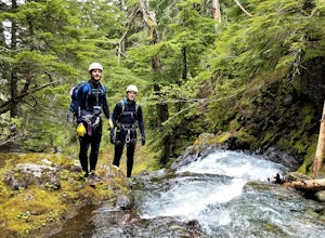
Canyoneering Olallie Creek, Mt. Rainier
2.5 mi / 700 ft gainDisclaimer: Canyoneering is a dangerous and technical activity. Don’t enter any canyon without the skills to match it, or the knowledge to navigate it. Be sure to check the flow of Olallie creek to ensure that it's safe. In an area where canyoneering isn’t hugely popular, here lies a canyon that ...Read more -
Packwood, Washington
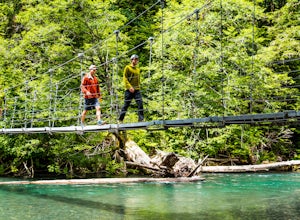
Hike the Grove of the Patriarchs
3.01.5 miThis trail is an easy trail to hike to the end and back. With very little to no elevation gain, some comfy shoes is all you need. There is a great opportunity near the start of the trail to walk down onto the beach and get right next to the river. Shortly after that there is a suspension bridge t...Read more -
Randle, Washington
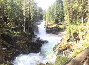
Trail Run to Silver Falls
5.02.4 mi / 200 ft gainThis is a trail that could easily be done by your older family members but also could be a nice trail run or quick hike for you. The trail starts from Loop B in the Ohanapecosh Campground and after a quick section, you will be walking over the hot springs in the area. They ask that you stay off t...Read more

