
Camp in the Coconino National Forest
Flagstaff, Arizona
Description
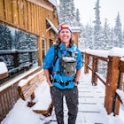
Added by Kristen May
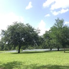
The many forest and fire roads in the Coconino National Forest just outside of Flagstaff, Arizona offer some of the most beautiful free camping spots around. From mountain views to the views of a dormant volcano, you can expect to enjoy every single sight you will see along the way.
The free camping in the Coconino (as well as the many other national forests) is generally along the old Fire Roads, and old Forest Service Roads. You can tell if a road is one of these by a brown sign with an FS 123 or any other number, FS meaning Forest Service Road. There are many of these roads just outside the Sunset Crater Volcano National Monument on Highway 89 Heading in the direction of Flagstaff, Arizona.
Once on the Forest Service Road you will begin to follow a typically rocky or dirt path and see fire rings and pull off's on the sides of the road. Pull off and park at whichever one of these campsites you like. Some service roads will have signs dictating that you have to drive a certain distance down the roads to reach the free camping. If that's the case, follow the road until you find a place that looks right for you!
The forest service road that we stayed on for these photos was FS Road 776, and the coordinates to our site was 35.331181, -111.517855. If this exact spot is taken than you can continue down the forest service road as their are many other amazing spots on it as well. If you are heading towards Flagstaff on highway 89 this service road is going to be on your left at the coordinates 35.328599, -111.545429
If you are road tripping, national forests make for an amazing no cost camping opportunity with beautiful views and seclusion.
Please note that these sites are very primitive - no restrooms, running water, or facilities of any kind will be found. A permit is not required in this National Forest.
Download Outbound mobile app
Find adventures and camping on the go, share photos, use GPX tracks, and download maps for offline use.
Get the appFeatures
Camp in the Coconino National Forest Reviews

This area is REMOTE. Be sure you have enough water as there are very few sources to filter water in this area.
4.0

Caution! Forest Service roads with number signs and obvious tire tracks may be officially closed to public use. Use each Forest's free MVUM, available at the visitor centers, some retailers and on-line. The MVUM is the legal document showing open roads. In general, if the road you want to take on the Forest is not on the map, even if it is on the ground, signed and being used, it is legally closed to vehicular traffic. It would take too long to explain the whys here, so talk to the folks at the USFS visitor center for an explanation. As an aside, I worked for the US Forest Service from 1995 to 2005 on the Coconino, Tonto and Gila National Forests when this state of affairs began.
3.0
Swung through on the way to GCNP. Really nice area, although sites are hard to find in winter. With any snow cover you would want 4WD.
4.0
If you love the smell of ponderosa trees (think pine with a hint of butterscotch), you'll love camping here.
4.0
Leave No Trace
Always practice Leave No Trace ethics on your adventures and follow local regulations. Please explore responsibly!
Nearby

Hike the Lava Flow Trail at Sunset Crater Volcano National Monument

Trail Run in Lockett Meadow

Hike Inner Basin Trail #29

Bike along the San Francisco Peaks on Waterline Road

Humphreys Peak Summit

Fatman's Loop
Discover
Community
Mobile Apps

© 2026 The Outbound Collective - Terms of Use - Privacy Policy