

Camp at Cape Disappointment
Ilwaco, Washington
4.5
Don't let the name fool you, this over 1,700 acre state park offers plenty for the outdoor enthusiast. The cape was named by explorer John Meares after a failed attempt to enter the Columbia River. Lucky for you, maps have been upgraded and the river mouth and cape are no long as challenging to come across.
If you're lucky enough to choose whichever campsite you want, look for either 104 or 105...

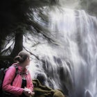
Spirit Falls
Cook, Washington
4.0
1.5 mi
/ 516 ft gain
NOTE: Access to this hike is currently closed. A Part of this hike goes through private land. At this time, the landowner is not granting access to hikers.
There are no signs or trail head for the falls, but it's a popular spot for kayakers and photographers, so look for a faint boot path directly from the pulloff on Cook Underwood Road and follow it to the river.
The hike is short, but very ...

Falls Creek Falls
Carson, Washington
4.8
5.82 mi
/ 1512 ft gain
The trail to Falls Creek Falls is well maintained with a few short moderately steep areas. The trail hugs the creek for the first mile, and takes you through old growth trees for the second mile. Once the falls are in sight, make sure to stop and look up to see the top tier through the trees. It's not visible otherwise. The trail ends with with an impressive view of the middle and lower tier.
...
")
Fall Creek Falls (aka Stella Falls)
Longview, Washington
4.0
From Interstate 5 in Kelso, exit onto Highway 4 and follow it west towards Cathlamet and Long Beach for about 11.3 miles. A quarter mile east of the town of Stella is Fall Creek, with Fall Creek Falls, or Stella Falls as it is sometimes called, visible from the highway. Watch for the falls through the trees on the north side of the road. If you cross Germany Creek you've got about 4/10ths of a ...

Steep Creek Falls
Carson, Washington
5.0
Steep Creek Falls is located about 5 miles from the small town of Stevenson. Take Highway 14 one mile west of Stevenson to Rock Creek Drive and turn north, passing the Skamania Lodge and Resort. Turn left onto Ryan Allen Road and follow it for about a mile, then turn left onto Red Bluff Road. Follow this gravel, pothole road 5 1½ miles to a bridge crossing Rock Creek. Find a place to pull off ...

Snow Hike to Wahclella Falls
Cascade Locks, Oregon
4.0
2 mi
The wooden bridges, Munra Falls, beautiful canyon walls, and the mossy grotto at the end of the canyon itself would be enough of a draw for this hike, but you round the last corner and 65 foot Wahclella Falls comes in full view.The big snow covered river rocks looked like giant marshmallows, and Wahclella fully shined as the main attraction. It was truly a winter wonderland.Normally, this is ea...

Lower Starvation Ridge Loop
Cascade Locks, Oregon
3.7
2.69 mi
/ 1001 ft gain
Starvation Creek Falls is an impressive 190 ft. waterfall just a few feet from the parking lot. If you don't know it's there, you'll miss it. Keep walking past the restrooms, away from the trail head to see this beautiful two-tiered waterfall. There are a couple of picnic tables near the creek to enjoy a snack before your hike.
Most of the loop is pretty easy, except for the first half-mile cl...

McClellan Falls
Skamania County, Washington
1.0
0.7 mi
/ 200 ft gain
The trail begins at the parking for McClellan Overlook. Head out of the parking area and cross over the highway before heading onto a faint, unmarked trail. You may have to do a little routefinding, so it's best to download this map before heading out so you can make sure you stay on path.
This is a steep, dangerous hike with thick brush so it would be best to leave dogs and children home.
W...

Trillium Lake
Government Camp, Oregon
4.9
1.89 mi
/ 108 ft gain
Trillium Lake is a popular camp spot at the base of Mount Hood. It's known for it's scenery, abundant recreational activities, and is family friendly. Boating, swimming and fishing are quite popular on the 63 acre lake. There is a small boat ramp within the campground and a larger ramp available in the day use area. An accessible fishing pier is also available.
My friend and I just went down f...

Panther Creek Falls
Carson, Washington
4.6
0.64 mi
/ 180 ft gain
This hidden beauty is just north of Carson, Washington. Watch for Panther Creek campground signs and follow the twisting road about 7 miles to a rock quarry and park there. The trail begins just off the road about 50 yards back - keep an eye out for signs for the trailhead and listen for the falls. From here it's a short walk to a wooden viewing platform with a well maintained trail. It's a nic...

Camp at Takhlakh Lake
Skamania County, Washington
5.0
Takhlakh Lake is located 7 miles NW of Mt Adams with a 53 site campground on the west side of the lake as well as a day use picnic area.The campground features a boat ramp and a wheelchair-accessible 1.1 mile flat trail, which encircles the lake, and accesses the Meadows Trail that climbs up to the edge of old lava flows. From the top, you can see Mt. Rainier on a clear day.In 2013, National Ge...

Dog Mountain via Dog Mountain Trail
Stevenson, Washington
4.5
6.53 mi
/ 2858 ft gain
The Dog Mountain trailhead is located halfway between Stevenson and Bingen. Look for the big signed parking area just after milepost 53 (Eastbound). The parking lot fills up quickly, especially during peak wildflower season, so if you can go on a weekday that would be better.
There are 3 trails to the summit:
Augsberger trail is to the left of the parking area and is the most mellow. It has m...
Community
Mobile Apps

© 2024 The Outbound Collective - Terms of Use - Privacy Policy