Waynesville, North Carolina
Looking for the best hiking in Waynesville? We've got you covered with the top trails, trips, hiking, backpacking, camping and more around Waynesville. The detailed guides, photos, and reviews are all submitted by the Outbound community.
Top Hiking Spots in and near Waynesville
-
Del Rio, Tennessee
Max Patch Mountain
5.01.51 mi / 315 ft gainMax Patch Mountain was once cleared for pasture land, leaving an expansive flat summit that now serves as the ideal location for a picnic hike, flying a kite, or laying in the sun surrounded by the Great Smoky Mountains. With little elevation gain and a short distance it is also very family (and ...Read more -
Pisgah Forest, North Carolina
Drive the Forest Heritage National Scenic Byway
5.076 mi / 1000 ft gainYou can drive this highway getting different views during the different seasons. Along the drive, have your camera ready for beautiful vistas, Looking Glass Falls, and many adventures along the highway. The views are especially beautiful in the autumn with the leaves changing colors. This route d...Read more -
Bryson City, North Carolina
Charlies Bunion via Kephart Loop
14.14 mi / 3671 ft gainCharlies Bunion via Kephart Loop is a loop trail located near Cherokee, North Carolina. This is a longer version of the Charlies Bunion hike starting from the Newfound Gap parking lot. The added benefit of this longer loop is the opportunity to see more of the Great Smokey Mountains! You'll pass ...Read more -
Bryson City, North Carolina
Kephart Prong Trail, Great Smoky Mountains NP
5.03.92 mi / 850 ft gainKephart Prong is a pretty easy hike in close proximity to the Visitor Center on the North Carolina Side of GSMNP. 2 miles up the trail, you'll arrive at Kephart Shelter, where you can rest and enjoy vies of the Kephart Prong. Once you've had your fill, head back down the way you came. During th...Read more -
Arden, North Carolina
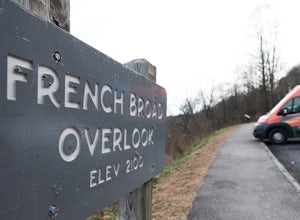
Photograph the French Broad Overlook
5.0The French Broad Overlook is one of several overlook spots along the Blue Ridge Parkway. It's not known to be the most breathtakingly scenic spot of the batch, but it's still a nice viewpoint that will offer you sights of the French Broad River, one of the few north flowing rivers in the US. Yo...Read more -
Cosby, Tennessee
Hike to the Mount Cammerer Lookout Tower
4.510.99 mi / 3040 ft gainMost visitors have a vision of how they'd like to see Great Smoky Mountains National Park, and it typically involves climbing to the top of a mountain like 4,928-foot Mount Cammerer. This is a very strenuous hike involving a breathtaking amount of elevation gain along the rugged Low Gap and Appal...Read more -
Cullowhee, North Carolina
Hike to High Falls
3.51.5 mi / 600 ft gainThis is an awesome hike if you're up for a challenge! The hike in isn't bad at all and the trail itself isn't super long but the climb back out will be a little more difficult due to the rock steps and lengthy uphill. This hike starts from a parking lot, just across the road from Lake Glenville a...Read more -
Cosby, Tennessee
Hike to Hen Wallow Falls in Great Smoky Mountains NP
5.04.57 miStart your adventure by parking in the Cosby Picnic Area Parking Lot near the entrance of the Cosby Campground. (127 Cosby Picnic Area Rd, Cosby, TN 37722.) Then backtrack through the parking lot about 100 yards until you see the sign marking the start of Gabes Mountain Trail. The trek to Hen W...Read more -
Glenville, North Carolina
Hike to Frolictown Falls
1.5 mi / 350 ft gainThis is an awesome hike to do if you're short on time or have hours to kill. Because it is so easy to access, it doesn't take very long to get down to it and can be accessed by two separate trails. Both trails are well maintained, however, while there are some blazes, it is not heavily marked. Th...Read more -
Glenville, North Carolina
Hike to Granny Burrell Falls
2.4 mi / 440 ft gainPanthertown Valley has a unique system of trails, with each trail having a specific number. Some of the trails listed at the information hut in the parking lot are accessed by taking one or two other trails to get to the start of the trail you are seeking. That is the case when hiking to Granny B...Read more -
Glenville, North Carolina
Hike to Wilderness Falls
1.4 mi / 300 ft gainWilderness Falls offers a beautiful hike with a simple yet captivating falls. All of the maintained trails in Pantertown Valley are marked by a number system (there is an information hut in the parking lot with information about other local trails, distance of different trails, and emergency cont...Read more -
Glenville, North Carolina
Hike to Blackrock Overlook
3 mi / 700 ft gainThis is probably one of my favorite hikes I've done in Panthertown Valley. Its also one of the easier views to access. You start from the Salt Rock Gap Parking lot, taking the Blackrock Trail (447) up Blackrock Mountain. This trail is located about 100 yards to the left if you are standing lookin...Read more -
Sylva, North Carolina
Hike to Cowee Bald Fire Tower
4.4 mi / 400 ft gainThe Cowee Bald Fire Tower is located in the Nantahala National Forest near Bryson City North Carolina. To get there you can either drive almost all the way to the top about .2 miles from the top but to get there you will need to have a 4WD or a higher clearance vehicle to cross a small stream. Ho...Read more -
Lake Toxaway, North Carolina
Hike to Raven Rock Falls
0.5 miIf you want to see a great waterfall without hiking all day, this is the perfect trail for you. Getting there - The trailhead is about 2 miles from the intersection of Cold Mountain and Panther Ridge Road (exact coordinates: 35.1594, -82.9801). There is a small grassy pull out where you can park...Read more -
Lake Toxaway, North Carolina
Hike to Schoolhouse Falls and Little Green
5.03 miTrail signs in Panthertown Valley are limited. Be sure to bring a map! Starting at the Cold Mountain parking lot, hike to Schoolhouse Falls. This is a nice waterfall with a pool at the bottom. In the summer, you are bound to run into other fellow hikers here. From Schoolhouse Falls, you have the...Read more -
Lake Toxaway, North Carolina
Hike to Warden, Jawbone, and Riding Ford Falls
4.5 miWarden, Jawbone, and Riding Ford Falls are three waterfalls located along the headwaters of the Tuckasegee River in Panthertown Valley. Not far from the Cold Mountain trailhead, these falls are quite popular in the summer. On a weekend, you will often find people playing in the pools below the fa...Read more


