Sedalia, Colorado
Looking for the best photography in Sedalia? We've got you covered with the top trails, trips, hiking, backpacking, camping and more around Sedalia. The detailed guides, photos, and reviews are all submitted by the Outbound community.
Top Photography Spots in and near Sedalia
-
Conifer, Colorado
Elk Falls Loop
3.512.76 mi / 1893 ft gainBegin on Staunton Ranch Trail for 3.3 miles. Switch to Bugling Elk Trail for the next 1.1 miles, then to Lion's Back Trail for the last mile to the overlook. From here, you can create the loop by backtracking to the Chimney Rock Trail, which then connects with the Elk Falls Trail. To head back to...Read more -
Bailey, Colorado
Payne Creek Trail via Brookside McCurdy Trailhead
4.517.98 mi / 3773 ft gainDay 1: Park at the Payne Creek/Brookside Trailhead (8,040 ft.) right outside Bailey. You'll go on the trail for about a mile before the trail parts to Craig Meadows or Craig Park. If you start this in the nighttime, it's best to camp before you part ways on the trail as it's a little more spaciou...Read more -
Castle Pines, Colorado
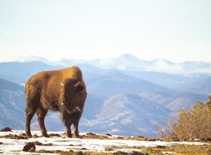
Explore Daniel's Park
Daniel's Park is a small park in Douglas County that offers unparalleled views of the front range. There is a small walking trail that follows the road if you choose to go on foot, or you can stay in the car and drive the length of Daniel's Park Road. There is a bison herd that calls Daniels Park...Read more -
Littleton, Colorado
Hike the Meadowlark Plymouth Trail
4.06 mi / 1197 ft gainFrom the parking lot, you can take the Meadowlark trail to the west or the Plymouth Creek Trail to the southeast. It does not matter which trail you take because it ends up becoming loop. For a more gradual slope up the hill, take the Meadowlark trail. After a little more than a mile, it intersec...Read more -
Divide, Colorado
Hike to Raspberry Mountain
5.05.2 mi / 900 ft gainTake US-24 west and turn left at traffic light in Divide. Drive south on US-67 for about 4 miles. Turn left to CR-62 right after you pass the entrance to Mueller State park on the right. Drive about a mile on the dirt road and you will see the new trailhead parking lot on the left side.Once you p...Read more -
Littleton, Colorado
Hike or Bike Hildebrand Ranch
4.05.1 mi / 324 ft gainHildebrand Ranch Park is often overshadowed by the other nearby Jeffco Parks, but for the few that it does attract the trails do not disappoint. The Two Brands Trail starts at about 5600ft just off of Deer Creek Canyon Rd. It is a relatively flat trail that tops out at about 5821ft making it a...Read more -
Divide, Colorado
Summit The Crags
4.67.9 mi / 1379 ft gainAs you drive past Mueller state park (on the right), about 1/4 mile down the road you will see a small wooden sign for "The Crags" You will take a left there and follow the road about 1.5 miles, past the first stop, which is the Raspberry Mountain Trailhead, until you come to a fork in the road a...Read more -
Littleton, Colorado
Hike the Coyote Song-Swallow Trail Loop
3.83 mi / 350 ft gainWe all love to live our weekends to the fullest, but say you're itching for an adventure and it's midweek with the weekend still a good 3 or 4 days away? South Valley Park is the place to go if you're looking for an after-work adventure or just don't feel like driving too far from the city. A sho...Read more -
Colorado Springs, Colorado
Hike to Blodgett Peak
3.04.5 mi / 2325 ft gainGetting There Google Maps + "Blodgett Peak Open Space"= Easy Peasy. The parking lot only accommodates 11 cars with a one of those reserved for handicap. A port-a-potty is the only facility available at the trail head, so plan accordingly. The Hike Starting out at about 7,000 feet the first mile ...Read more -
Woodland Park, Colorado
Ski Pikes Peak
Pikes Peak Toll Road can grant you access to a ton of super accessible backcountry skiing if you have the equipment and knowledge. From roughly Glen Cove up to the summit of the mountain you can access terrain varying from steep chutes off the summit to easy glades in an abandoned ski resort. T...Read more -
Franktown, Colorado
Hike the Canyon View Nature Trail, Castlewood Canyon
4.52.4 miThis is a well maintained, easy trail best hiked in spring and fall. Conditions make this trail great for families. The park is also popular for bird watching and rock climbing.Read more -
Lone Tree, Colorado
Hike Bluffs Regional Park Trail
2.7 mi / 200 ft gainThis loop trail is 2.7 miles long but has several options for overlooks that add 0.8 miles to the trip. This is an easy hike with minimal elevation gain and is a great option for the whole family. Every time I've done this hike I've seen numerous deer which only adds to the hike!Read more -
Lake George, Colorado
Camp and Fish at Eleven Mile Canyon
4.4Located below the dam of the Eleven Mile Reservoir, Eleven Mile Canyon is a scenic spot for camping, fishing, hiking and climbing. There are four different campgrounds to choose from (Cove, Riverside, Spillway and Springer), though only one campground remains open during the off season. Getting t...Read more -
Divide, Colorado
Snowshoeing to Sentinel Point
8 miSentinel Point is an appropriately-named 12,527-foot rockpile standing watch over the broad shoulder of the Pikes Peak massif. Rarely visited, especially in winter, you are almost guaranteed solitude on this high mountain snowshoeing adventure.Beginning at the Horsethief Park trailhead off CO Ro...Read more -
Divide, Colorado
Hike to Horsethief Falls and Pancake Rocks
4.87.6 mi / 1400 ft gainHorsethief Falls and Pancake Rocks can be found on the west side of Pikes Peak, so if you want to get away from the crowds and the city, put this trail on your to do list.Most of the trail runs through the forest, which makes this an excellent candidate for hiking in July and August when the summ...Read more -
Evergreen, Colorado
Maxwell Falls
3.43.95 mi / 928 ft gainLocated just outside of Evergreen, this beginner hike is a great escape from the city for a few hours. There are three different options to hike to the falls: Maxwell Falls Lower Trail (4 miles), Upper Maxwell Falls Trail (1.1 miles), and Maxwell Falls Bluffs Cliffside Trail Loop (5 miles). On th...Read more

