The Best Camping in Winters
Looking for the best camping in Winters? We've got you covered with the top trails, trips, hiking, backpacking, camping and more around Winters. The detailed guides, photos, and reviews are all submitted by the Outbound community.
Top camping spots in and near Winters
-
St. Helena, California
Creekside Nature Trail
0.39 mi / 49 ft gainCreekside Nature Trail is an out-and-back trail where you may see wildflowers located near Napa, California.Read more -
Calistoga, California
Camp at Bothe-Napa Valley SP
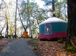
4.5Looking for a romantic getaway but you’d prefer to spend your nights around a campfire? This adventure is for you. This beautiful Napa Valley campground has it all – 10 miles of hiking trails, 1,900 acres to explore, and…new yurts! Yurts are basically cool circular tents that allow you enjoy the ...Read more -
Saint Helena, California
Hike Bald Mountain, Sugarloaf Ridge SP
5.06 mi / 1540 ft gainPark at the top of Adobe Canyon Road in the gravel parking lot to the left of the ranger kiosk. There is a $7.00 parking fee.There are many options for routes to the top; the easiest of which is mostly paved (although still steep in parts). To take this route, head north out of the trailhead park...Read more -
Vallejo, California
Camp at Mare Island Shoreline Heritage Preserve
1 mi / 20 ft gainThis old Naval Base is now home to, well, almost nothing. As a weekend volunteer trip, myself and about 50 others got a little dirty creating 3 new campsites for you and your friends!During the day, the island has hikers exploring everywhere, but the preserve closes upon sunset and it's just you ...Read more -
Clearlake Oaks, California
Lynch Canyon Trail
3.26 mi / 299 ft gainLynch Canyon Trail is an out-and-back trail that is good for all skill levels located near Williams, California.Read more -
Clayton, California
Hike the Donner Creek Trail
5.2 mi / 1322 ft gainThe Donner Creek Loop Trail is a moderate, 5.2 mile loop hike. Just outside of Clayton, California, this hike is perfect for Bay Area residents. The trail is open year-round, and the waterfalls are particularly impressive in the winter. This trail is open to horses but not dogs. Trail directi...Read more -
Walnut Creek, California
Mount Diablo North Peak Trail
6.18 mi / 2133 ft gainMount Diablo North Peak Trail is an out-and-back trail where you may see beautiful wildflowers located near Walnut Creek, California.Read more -
Walnut Creek, California
Camp at Juniper Campground in Mount Diablo SP
Mount Diablo's summit in Mount Diablo State Park rises to 3,848ft, with Juniper Campground in Mount Diablo SP is at approximately 3,000ft in elevation. Juniper Campground overlooks the valley below and some of the San Francisco Bay. Reservations for Juniper Campground can be made at Reserveamer...Read more -
Middletown, California
Boggs Mountain Loop
8.94 mi / 1302 ft gainBoggs Mountain Loop is a loop trail that is moderately difficult located near Middletown, California.Read more -
Alamo, California
Pine Creek and Wall Point Trail
4.05 mi / 574 ft gainPine Creek and Wall Point Trail is a loop trail that takes you by a river located near Alamo, California.Read more -
Alamo, California
Green Valley to Wall Point Road Loop
7.09 mi / 1375 ft gainGreen Valley to Wall Point Road Loop is a loop trail where you may see beautiful wildflowers located near Diablo, California.Read more -
Danville, California
Rock City to the Summit of Mount Diablo
7.77 mi / 2382 ft gainRock City to the Summit of Mount Diablo is an out-and-back trail where you may see wildflowers located near Danville, California.Read more -
Brentwood, California
Miwok Trail and Hardy Canyon Loop Trail
4.61 mi / 1027 ft gainMiwok Trail and Hardy Canyon Loop Trail is a loop trail that takes you by a river located near Brentwood, California.Read more -
Oakland, California
Hike the French Trail and Stream Trail via Skyline Blvd
4.07.8 mi / 1781 ft gainThe French Trail and Stream Trail via Skyline Blvd is a 7.8 mile loop with lots of ups and down, perfect for trail runners, hikers, and dog walkers. The trail is well-shaded, and is accessible year round. Parking can be found at the Skyline Gate Staging Area at Pine Hills Drive. This is a great ...Read more -
Oakland, California
West Ridge Trail: Skyline Gate to MacDonald Gate
8.19 mi / 1588 ft gainWest Ridge Trail: Skyline Gate to MacDonald Gate is an out-and-back trail where you may see wildflowers located near Redwood City, California.Read more -
Pilot Hill, California
Peninsula Campground to First Cove Loop
5.33 mi / 568 ft gainPeninsula Campground to First Cove Loop is a loop trail that takes you by a lake located near Pilot Hill, California.Read more