Emeryville, California
Looking for the best hiking in Emeryville? We've got you covered with the top trails, trips, hiking, backpacking, camping and more around Emeryville. The detailed guides, photos, and reviews are all submitted by the Outbound community.
Top Hiking Spots in and near Emeryville
-
Sausalito, California
Ninja Loop
9.37 mi / 1831 ft gainThis loop can start from several different locations, including Rodeo Beach and the Golden Gate Bridge parking lot. Starting from the GGB will add 2 more miles onto this run. I like to start at the Coastal Trailhead parking lot off of McCullough and Conzelman Roads (just a notch down from Hawk Hi...Read more -
Sausalito, California
Marin Headlands Trail Loop
10.5 mi / 1990 ft gainThis trail starts at the Coastal Trail in Marin Headlands Park, where there's a small parking lot and outhouse bathroom off the circle when coming from Conzelman Road.Take the Coastal Trail until you intersect with Bunker Road (you can even turn right and spit off the trail just before intersecti...Read more -
Sausalito, California
Hawk Hill
5.00.76 mi / 144 ft gainIf you're leaving from SF, head over the bridge and exit onto Alexander Ave. Make the immediate left under the overpass and you'll be on the road to Hawk Hill. There's a parking area just below the gate leading up to Hawk Hill. From the parking lot you can walk west about ten yards along the outs...Read more -
Richmond, California
Explore Point Pinole Shoreline
5.0Point Pinole Regional Shoreline is a 2,315-acre parkland that juts out into the San Pablo Bay. Only a brief car ride from San Francisco, this is a great spot for a Sunday stroll, picnic or simply to find a quiet space.There are several short trails to choose from that wind through eucalyptus grov...Read more -
San Francisco, California
Lands End Trail
4.73.26 mi / 500 ft gainThe Lands End Trail is a 3.26 mile out-and-back hike located in the northwest corner of San Francisco along the city's rugged coastline. Offering spectacular views of the Golden Gate Bridge, Marin Headlands, and the Pacific Ocean, the hike is one of the most popular trails in San Francisco for ...Read more -
San Francisco, California
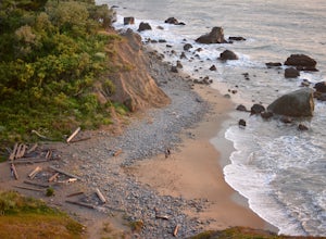
Mile Rock Beach
4.71.64 miThis rocky, secluded beach is tucked in along the Land’s End Coastal Trail in the Golden Gate National Recreation Area. Located 100 or so steps down from the main trail, you’ll find this mysterious little beach that will make you feel like you’re in an old pirate movie. There are a lot of logs an...Read more -
Tiburon, California
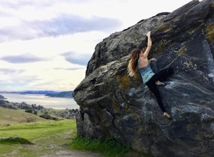
Bouldering at Ring Mountain
0.5 mi / 400 ft gainItching to climb outdoors near San Francisco? With only a quick drive from the city, Ring Mountain is a beautiful nature preserve overlooking the city of San Francisco offering two main rock formations, Turtle Rock (Pictured) and Split Rock. Split Rock is the slabby rock south of the parking ar...Read more -
Sausalito, California
Black Sands Beach
5.00.54 mi / 285 ft gainBlack Sand Beach is a beautiful, mile-long stretch of black sand just north of the Golden Gate Bridge. On a sunny day, it’s best to try and arrive in the morning, as the parking lot can fill up quickly. To get down to the beach, you’ll need to hike for about 5 minutes down 250 or so wooden steps....Read more -
Daly City, California
San Bruno Mountain
4.03.63 mi / 781 ft gainSan Bruno Mountain is a fun, mellow hike that climbs easily on a well-graded path to the ridge line, and then drops back to the trailhead. Along the way, the trail runs along a creek, ascends through chaparral, and provides excellent views of downtown San Francisco, the East Bay hills, and the Sa...Read more -
Castro Valley, California
Lake Chabot Regional Park Loop
4.08.65 mi / 1263 ft gainLooking for a fun day on a lake, but don't want to drive too far? We recommend heading out to the East Bay where you can combine a nice hike with an afternoon of fishing. This moderately challenging hike remains scenic throughout the 8.5 mile trek around the lake, and offers many opportunities fo...Read more -
Moraga, California
Bollinger Creek Loop Trail
1.43 mi / 213 ft gainLas Trampas Regional Wilderness offers an extensive trail system for hikers, horseback riders and mountain bikers. The trail is open year round and dogs are allowed. The Las Trampas and Bollinger faults spread apart to reveal a wonderful wilderness area with ancient remnants of beaches. The entir...Read more -
Corte Madera, California
Ring Mountain Loop
4.02.65 mi / 597 ft gainRing Mountain Open Space is an easy but uphill trail that take you to the top where you can explore more trails. Take the 101 exit for Paradise Dr in Corte Madera, follow the road, and park on the side of the road once you pass Westward Dr. Even though there are many places to start the trail fo...Read more -
Mill Valley, California
Rodeo Cove to Point Bonita Lighthouse
5.03.64 mi / 568 ft gainIf you're looking for a little hike and a lot of beach, you'll find your ideal combo at Rodeo Beach and Point Bonita Lighthouse. Park at the Marin Headlands Visitor Center at the head of the 0.8 mile trail to the beach. From the lighthouse to the beach, it will be another 1.5-2 miles there and ba...Read more -
Mill Valley, California
Miwok, Marincello and Bobcat Trail
8.17 mi / 1391 ft gainMiwok, Marincello and Bobcat Trail is a loop trail that takes you by a river located near Sausalito, California.Read more -
Mill Valley, California
Oakwood Trail, Marin Headlands
5.02.56 mi / 538 ft gainLooking to escape the hustle of San Francisco, but don't want to commit to an entire day on the trail? When setting out for this morning hike, be prepared for about 1.5 hour hiking adventure (longer if you stop for extra photos) and a 20 minute commute from San Francisco. This hike is recomend...Read more -
Walnut Creek, California
Sugarloaf Open Space Loop
1.91 mi / 243 ft gainSugarloaf Open Space Loop is an almost 2-mile loop for hiking, running and walking. This trail is relatively easy and takes under one hour to hike. This loop is dog friendly.Read more

