Crockett, California
The best Trails and Outdoor Activities in Crockett, California, offer a wealth of scenic adventures. A top pick is the Crockett Hills Regional Park, a must-visit for its unique array of wildflowers and bird species. The Sky Trail offers panoramic views of Carquinez Strait and San Pablo Bay, while the Sugar City Trail provides glimpses of the old sugar mill. The park is also home to a variety of wildlife, including deer, foxes, and hawks. The trail difficulty varies from moderate to challenging, making it suitable for all fitness levels. For water-related activities, the nearby Carquinez Strait offers opportunities for fishing and boating. Crockett's outdoor attractions showcase the best of California's diverse landscapes.
Top Spots in and near Crockett
-
Belvedere Tiburon, California
Mt. Livermore via North Ridge Trail
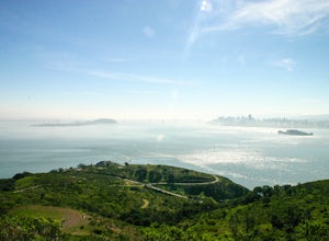
4.54.92 mi / 1178 ft gainUnless you own a boat or a kayak, this adventure requires a ride on the Blue and Gold Ferry from Pier 41 in San Francisco. But let’s be honest, that’s actually half the fun. Who doesn’t love a ferry ride? Angel Island State Park is the largest island in the Bay, and recommend the 6-mile loop aro...Read more -
Tiburon, California
Camp on Angel Island
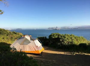
5.0Thousands of years ago, this island was a fishing and hunting ground for the Miwok Native Americans. It has also been an outpost for the U.S. Army and a cattle ranch. Now, it’s one of the closest places to escape from the hustle of San Francisco and set up camp. Camping on the island requires ba...Read more -
Tiburon, California
Bouldering at Ring Mountain
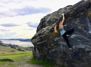
0.5 mi / 400 ft gainItching to climb outdoors near San Francisco? With only a quick drive from the city, Ring Mountain is a beautiful nature preserve overlooking the city of San Francisco offering two main rock formations, Turtle Rock (Pictured) and Split Rock. Split Rock is the slabby rock south of the parking ar...Read more -
Oakland, California
Run the Circumnavigation of Redwood Regional Park's Ultimate Trail Loop
5.07.5 mi / 1600 ft gainIt’s difficult to have a car in San Francisco, but oh-so worth it when it comes to weekend getaways, especially with all the Bay Area has to offer. This is a super accessible trail system just 30 minutes outside of the city that makes for a fun, easy trail run or hike.Redwood Regional Park, part ...Read more -
Corte Madera, California
Ring Mountain Loop
4.02.65 mi / 597 ft gainRing Mountain Open Space is an easy but uphill trail that take you to the top where you can explore more trails. Take the 101 exit for Paradise Dr in Corte Madera, follow the road, and park on the side of the road once you pass Westward Dr. Even though there are many places to start the trail fo...Read more -
Clayton, California
Hike the Waterfalls of Mount Diablo Loop Trail
5.06 mi / 1627 ft gainWinter and spring rains create scenic waterfalls in this hike at Mount Diablo, the East Bay's signature peak. Be careful hiking immediately post-rain, watch for slippery sections of mud. The trail is moderately difficult and is used by hikers, walking groups, trail runners, and for nature trips. ...Read more -
Napa, California
Westwood Hills Park Loop
4.02.12 mi / 476 ft gainThis park can get a little crowded on weekends, so best to go early if possible. In terms of parking, there's a lot at the trailhead, but also plenty of available street parking. The loop can be broken up in a various ways as there are several offshoots from the main trailhead/trail leaving fro...Read more -
Moraga, California
Bollinger Creek Loop Trail
1.43 mi / 213 ft gainLas Trampas Regional Wilderness offers an extensive trail system for hikers, horseback riders and mountain bikers. The trail is open year round and dogs are allowed. The Las Trampas and Bollinger faults spread apart to reveal a wonderful wilderness area with ancient remnants of beaches. The entir...Read more -
Larkspur, California
King Mountain Loop Trail
3.53 mi / 755 ft gainThis beautiful hike takes you around King Mountain and through the King Mountain Open Space Preserve. The first .5 miles is on an exposed gravel fire road that is fairly steep, but the loop itself slopes gently around the mountain and through the forest, providing lots of shade. This is a an ea...Read more -
Walnut Creek, California
Camp at Juniper Campground in Mount Diablo SP
Mount Diablo's summit in Mount Diablo State Park rises to 3,848ft, with Juniper Campground in Mount Diablo SP is at approximately 3,000ft in elevation. Juniper Campground overlooks the valley below and some of the San Francisco Bay. Reservations for Juniper Campground can be made at Reserveamer...Read more -
Walnut Creek, California
Juniper to the Summit Loop Trail and Meridian Ridge
6.56 mi / 2037 ft gainJuniper to the Summit Loop Trail and Meridian Ridge is a loop trail that is strenuous located near Diablo, California.Read more -
San Rafael, California
Terra Linda Sleepy Hollow Ridge Trail
5.05.85 mi / 1089 ft gainThis San Rafael neighborhood trail is quite popular, but there is plenty of room for everyone and the parking is easy. After you park at the trailhead, you walk (or bike) up a relatively short and steep path that takes you to the beginning of the trail. This hike takes you along a scenic ridge ...Read more -
Larkspur, California
Baltimore Canyon Via Dawn Falls Trail Loop
5.93 mi / 1309 ft gainBaltimore Canyon via Dawn Falls Trail Loop is a loop trail that takes you through a forested setting at the start, up switchbacks to Dawn Falls, and then to views of King Mountain Open Space Preserve as you loop back along Southern Marin Line Road. This is a dog friendly (on-leash) trail located ...Read more -
Novato, California
North Levee Trail
3.78 mi / 157 ft gainNorth Levee Trail is a loop trail where you may see wildflowers located near Novato, California.Read more -
Novato, California
Buck Gulch Falls Trail
5.01.26 mi / 203 ft gainBuck Gulch Falls (also known as Fairway Falls) is an easy, scenic hike that takes you through a beautiful forest on your way to a 15-foot waterfall. This little neighborhood treasure is tucked away in Novato, CA at the end of Fairway Drive and there is ample parking near the trailhead. If you v...Read more -
Antioch, California
Hike the Old Homestead Loop
5.06.5 miThis is a fun day hike that takes you through the beautiful hills of the Black Diamond Mines Regional Preserve and a bit of the Contra Loma Recreational Area as well. You can hike here year round, but I suggest going in the spring time when the hills are covered in soft, green grass and the wild ...Read more

