
Matt Davis-Steep Ravine Loop
Stinson Beach, California
Details
Distance
6.62 miles
Elevation Gain
1726 ft
Route Type
Loop
Description
Added by Ryan Vermilion
Hike a loop on Mt. Tamalpais covering two of the most famous bay area trails: Dipsea and Steep Ravine. Experiencing amazing views of Pt. Reyes, the Pacific Ocean, waterfalls, and wildflowers.
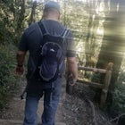
This loop is made up of three of the most popular Marin trails and for good reason. These trails offer not only expansive ocean views, but a variety of topography and environments. This 6+ mile loop offers up waterfalls, dense forests, redwoods, and open grasslands overlooking the pacific. Starting from the Stinson Beach Trailhead behind the fire station, you will cross over an old, wooden bridge and begin the ascent up the Matt Davis Trail. The trek upward may feel like it never ends, but just at ~2.5 miles, you'll receive a little reprieve. Stay on the Matt Davis trail, and head to the clearing, where you can enjoy ocean views, sights of Marin and SF.
As you exit the grassland, you'll cross over the Panoramic Highway, reaching the Pantoll Campground. Keep an eye out for traffic! Once you see the sign for the Steep Ravine Trail (downhill to your right before crossing Pantoll Rd or Deer Park Fire Rd), start your descent along the canyon wall. When you reach the top of the ladder on Steep Ravine, stop and get your obligatory photo opp in. Continue on Steep Ravine until you reach the Dipsea at approximately 6 miles in.
Once on the Dipsea, take the trail the remaining mileage back to the parking lot.
Print out the Tamalpais State Park Map before hitting the trail.
Download Outbound mobile app
Find adventures and camping on the go, share photos, use GPX tracks, and download maps for offline use.
Get the appFeatures
Matt Davis-Steep Ravine Loop Reviews
Enjoyable 4mile hike to the beach. Lots of shade until you get to the open field but you get the ocean breeze.
5.0

This trail has lots of fun climbing trees, views of Stinson beach, and hillsides. Be careful to follow the trail. Some parts get narrower and if you aren't paying attention it's possible to accidentally wander off.
4.0
September 10, 2017 8:00AM-3:00PM Did this during the heatwave hitting the bay. Started on the Matt Davis trail and did the loop. The trail entrance to the Matt Davis was so obscure and hidden. There are no signs showing you where it starts. My buddy and I walked around the neighborhood for awhile before we found it. It looks like a trail into someone's backyard and it felt like we were trespassing. The Matt Davis trail this day was so hot and dusty. I prefer the Steep Ravine part of this hike because it was cooler and more photogenic. Actually most (if not all) of those photos above are on the Steep Ravine part of the hike. Overall the hike did have a lot of variety. Ocean, beach, grassy hills, forest, steams, bridges, waterfalls, ladders.
3.0
This is one of my favorite hikes. I like to start from the top and park at Pantoll; gives you a break at Stinson beach and a nice climb at the end to make you aware of a workout :). I also like to switch it up sometimes between going down the steep ravine or taking the Old Mine trail to the Dipsea trail and get the nice coastal views on that side; coming back up Matt Davis. Or reverse it and go down Matt Davis and come back up Dipsea, staying to the right when it intersects with Steep Ravine and come back to Panroll via Old Mine trail.
5.0

This is a great hike. My GPS recorded 9.3 miles from starting at the firehouse to finishing at the firehouse. The beginning is all up hill, can be tough for some. You have some great views of the Pacific. When you come across the rolling hills and fields you get a wonderfully refreshing breeze to cool you off. The fields are a great place to have a snack and enjoy the view. The trail is great because you get a lil break to use the rest room and refill on water at the ranger station/campground. After that it's all down hill on the steep ravine trail. FYI- on weekends this trail can be very busy.
4.0
Love this hike. Challenging but so worth it. The switchbacks at the beginning of Matt David are particularly tough, but it flattens out for a bit before you head down through Steep Ravine. Lots of traffic on the path on the weekend too!Bring lots of water, snacks and plan to hang a Stinson for a bit afterwards. The Siren on the beach is perfect for a drink and snack at the end.
5.0
Leave No Trace
Always practice Leave No Trace ethics on your adventures and follow local regulations. Please explore responsibly!
Nearby

Matt Davis-Coastal Trail Loop

Dipsea Trail to Steep Ravine Trail Loop from Stinson

Cruising Pacific Coast Highway in Northern California

Bouldering & BBQ at Stinson

Stinson Beach

Rock Climbing Mickey's Beach
Discover
Community
Mobile Apps

© 2026 The Outbound Collective - Terms of Use - Privacy Policy