
Bald Mountain
Kamas, Utah
Details
Distance
2.73 miles
Elevation Gain
1050 ft
Route Type
Out-and-Back
Description
Added by Eric Harris
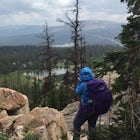
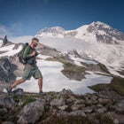
Bald Mountain is an easy hike to 11,943' summit with breathtaking 360° views of the High Uintas and Wasatch Range.
Bald Mountain is one of the most popular hikes in the Uintas, so get an early start if you want to beat the crowds. Those willing to hike in before dawn will be rewarded with an unforgettable sunrise at the summit. I HIGHLY recommend this as a sunrise hike.
The trail starts out with steep switchbacks for the first 0.6 mile, and then flattens out into a plateau. Towards the summit the trail steepens again and gets a little rougher as you navigate past large boulders. Here you will get a great view of the summit with Mirror Lake directly below.
When you reach the summit you are rewarded with an epic clifftop view of the High Uintas to the East and the Wasatch Range to the West. There are dozens of scattered lakes, including the popular Mirror Lake directly below. Keep an eye out for mountain goats which can often be spotted on the lower cliffs.
For more details on getting the best shots of Bald Mountain, check out this adventure for getting your pics.
Getting There: Drive 29 miles East of Kamas on Highway 150 and look for signs for the Bald Mountain Trailhead. The trailhead is about a 90 minute drive from downtown Salt Lake City.
Notes:
* Highway 150 is closed during winter and the area is only accessible by snowmobile* There are no backcountry campsites on the trail but there are plenty of campgrounds and dispersed camping options nearby* Use caution when hiking in the spring and early summer as snowy/icy conditions will likely exist* Average Temperatures at the Summit (High/Low °F) | January 14/-1 | Feb 16/1 | Mar 19/4 | Apr 27/11 | May 35/18 | June 45/25 | July 55/32 | Aug 53/31 | Sep 45/24 | Oct 34/15 | Nov 22/8 | Dec 17/3
Download Outbound mobile app
Find adventures and camping on the go, share photos, use GPX tracks, and download maps for offline use.
Get the appFeatures
Bald Mountain Reviews

They got a little frustrated as we would come over each ridge and still not be at the top, but they made it.
3.0
Where else can you start at 10,800 feet and end up at 11,943 feet in just over 2 miles? The Bald Mountain trail of course! This is a locals favorite for a reason. The panoramic views will take your breath away, literally! I would classify this hike as moderate for most, easy for some. It starts climbing right off the bat and really doesn't stop. Of course it all depends on your fitness level and how acclimated you are to elevation. The last time we hiked this trail, there were people who were visiting from Texas and some of them struggled. In addition, there are several places where the trail is narrow with steep cliffs and drop offs. Young children should be supervised in these spots. If you have a member of your group who is afraid of heights, I would take that into consideration. The final approach to the summit is a bit technical with large boulders but oh those views! This hike is best done mid to late July-September when the snow has melted. Plenty of water and sunscreen is a must, as much of this hike is above tree line. Because lightening is frequent here, avoid hiking when there is a threat of storms.
5.0
We ventured out to Bald Mountain on July 2nd 2016. Starting at about 630pm we made it up the trail in under 2 hours. Came across a herd of Mountain Goats with little kids that we watched for quite a while. Near the top of the mountain a different herd surprised us. When we reached the peak the temperature plummeted with the wind. I'd recommend bringing some kind of cold weather clothing for the peak. We waited for the sunset and wandered around the top. Don't forget to sign your name in a journal that's in the box tucked in the crevice on the East side of the peak. Super awesome sunset hike. Bring lights for the trek down if you do this for sunset.
5.0
This is one of the iconic hikes in the Uintas, and with such easy access it's hard to beat the rad views from the summit in all directions
5.0
Leave No Trace
Always practice Leave No Trace ethics on your adventures and follow local regulations. Please explore responsibly!
Nearby

Photograph Bald Mountain in Utah

Backpack to Notch Lake

Hike to Cuberant Lake

Hike the Lofty Lake Loop Trail

Camp at Pyramid Lake in Murdock Basin of Utah's Uinta Mountains

Hike to Weir Lake
Discover
Community
Mobile Apps

© 2026 The Outbound Collective - Terms of Use - Privacy Policy