Saratoga Springs, Utah
Top Spots in and near Saratoga Springs
-
Provo, Utah
The Y Trail
3.52.29 mi / 1063 ft gainHiking the Y is a classic hike in Provo, Utah—but don't expect it to be easy! There's no shade and not much greenery, so it's a hot, dusty trek to the top. Once you reach the Y, though, the view of the Provo and Utah Lake is amazing. There are also benches at the top. When you reach the Y, you w...Read more -
Provo, Utah
Hike to Stewart Falls
4.34 miThe canyon is closed during snowfall so this is only accessible between May-Nov usually. It is best during the fall when the leaves have changed color, but let's be honest, it's always great. Head up Provo Canyon and follow the signs to make a left going into Sundance. Follow the road past the sk...Read more -
Provo, Utah
Upper Falls
2.70.54 mi / 423 ft gainComing from Provo, at about 2.5 miles make a right hand turn for Nunn's Park/ Bridal Veil. Go straight through the intersections and pass Bridal Veil Falls (on your right) and continue until you see a park on your right (Upper Falls Park). Park here and cross the bridge over the creek and then fo...Read more -
Sandy, Utah
Bell Canyon's Waterfall
4.64.64 mi / 1549 ft gainIf you keep a steady pace, the hike takes about an hour each way, so allow time when trying to catch the sunset. The hike is pretty easy until right before you reach the falls, where there is a big, steep hill you have to climb. From the parking lot/trailhead, head up the path and head left when...Read more -
Provo, Utah
Hike to Summit of Buffalo Peak
1 mi / 500 ft gainDrive up Provo Canyon and turn right on Squaw Peak Road. Follow the road til you reach the T in the road and head left on Road 027. Follow it 2.9 miles to the unmarked trail head. It is located next to a wooden fence on the right of the road and next to a sign about fire and wildlife safety. ...Read more -
Provo, Utah
Buffalo Peak Trail
0.97 mi / 213 ft gainBuffalo Peak Trail is an out-and-back trail where you may see wildflowers located near Provo, Utah.Read more -
Provo, Utah
Backpack to Silver Lake
4.44.1 mi / 1500 ft gainThe trail is 4.1 miles roundtrip gaining almost 1,500 feet for the duration of the adventure. Some parts are exposed, so you can get a fair amount of sun.When you're on the trail, you'll get amazing views as you’re hiking to the lake of Mount Timpanogos and American Fork Canyon. This is followed ...Read more -
Provo, Utah
Camp at Silver Lake
4.54.4 mi / 1500 ft gainSilver Lake is a wonderful place to go if you're in need of a quick adventure in the woods. Located in the the Uinta National Forest, Silver Lake is relatively easy to get to via American Fork Canyon in Utah, however I do recommend driving a car with 4WD and can handle steep dirt roads with shar...Read more -
Provo, Utah
Hike to the Summit of Buckley Mountain
4.018 mi / 5000 ft gainThere are a few ways to get to the top of Buckley, but the funnest (and most strenuous) way to get up to Buckley is taking the trail up Slate Canyon. Slate Canyon has a parking lot and bathroom located at the base of the trail, and the trailhead is about ten minutes from the Provo Center Street e...Read more -
Provo, Utah
Floating the Provo River
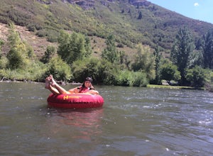
4.3There's no better way than spending a hot summer day floating down a river with your friends. The Provo River offers incredible views of Mount Timpanogos and other surrounding mountains in the Provo Canyon. The easiest way to do this adventure is to visit High Country Adventure in the Provo Cany...Read more -
Sandy, Utah
Explore Little Cottonwood Canyon's Lisa Falls
3.8Lisa Falls sits approximately 0.22 miles from Little Cottonwood Canyon Road. While the trail is not long or particularly steep, there are some large step ups that could be difficult for either the very old or very young. Nonetheless, this is a great option for a family outing.Once you arrive at t...Read more -
Sandy, Utah
Summit the Pfeifferhorn
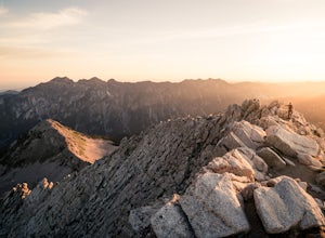
5.09 mi / 3700 ft gainStarting at the White Pine Trailhead in Little Cottonwood Canyon, UT, hike southwest until reaching the junction to Red Pine Canyon. Take the trail that crosses the stream and continues west around the ridge. The trail will quickly turn south and begin to gain elevation. Continue west as you pass...Read more -
Sandy, Utah
Hike to Maybird Lakes (Maybird Gulch)
5.07.5 mi / 2000 ft gainThis out and back hike begins at the same trailhead as White Pine Lake and Red Pine Lake which are both a lot more popular that Maybird Lakes. You follow the trail to Red Pine Lake for the first 2.5 miles and then there is a bridge and you follow that across the river to get on the trail to Maybi...Read more -
Sandy, Utah
Camp at the Cottonwood Ridgeline
Begin at the White Pine Trailhead in Little Cottonwood Canyon. Follow the trail up toward Red Pine Lake. The trail gets a little hard to follow after the lake, but find your way up to the ridge between Pfeifferhorn and White Baldy. Set up camp and enjoy a night in the high mountains. Morning will...Read more -
Sandy, Utah
Winter Hike the Pfeifferhorn
5.09 mi / 3600 ft gainRising to a height of 11,326 feet, the Pfeifferhorn is one of the most majestic and iconic peaks in the Wasatch Mountains, and also one of the most popular mountains to hike. During the summer and fall, there is a well beaten trail all the way to the summit, but during the winter and spring, this...Read more -
Sandy, Utah
Ski or Snowboard Pink Pine Ridge
Arrive at the White Pine Trailhead early and start up from the main trailhead. Stay on that trail until you hit the river (Most of the time the river is buried, so look for a sign sticking up out of the snow) and the fork to go up to White Pine or Red Pine. Cross the river heading west and contin...Read more

