Stamford, Connecticut
Looking for the best photography in Stamford? We've got you covered with the top trails, trips, hiking, backpacking, camping and more around Stamford. The detailed guides, photos, and reviews are all submitted by the Outbound community.
Top Photography Spots in and near Stamford
-
Hamden, Connecticut
Hike the Tower Trail to the Blue Trail at Sleeping Giant SP
5.03 mi / 518 ft gainSleeping Giant State Park is a place very close to my heart. I spent 4 years right across the street at Quinnipiac University and have hiked “The Giant” more times then I can count and at all different hours. There are a few different trails you can explore but my favorite one is up to the cliffs...Read more -
Hamden, Connecticut
Hike the Mill River Trail to the Blue Trail at Sleeping Giant SP
5.03 mi / 518 ft gainSince I was a child, I’ve always enjoyed hiking the Giant. As Connecticut parks go, this terrain is some of the most challenging (and unfortunately, the most dangerous) in the state. The actual ridge is approximately 2.75 miles long by 1.75 miles wide, and offers approximately 24 miles of hiking ...Read more -
Cheshire, Connecticut
Hike to Roaring Brook Falls
1.2 mi / 377 ft gainArriving to the falls, parking is residential but don't worry everyone is friendly. Starting off the hike you will walk past a cool pond where you may be able to see some wildlife. Continuing on, you will follow the marked trail where it will take you further into the woods while gaining elevatio...Read more -
West Milford, New Jersey
Hike the Terrace Pond North - South Loop
10.7 mi / 1200 ft gainFrom Warwick Road, parking at the northernmost road side parking area, cross the road, and the Terrace Pond North trail (marked with blue blazes) begins as a steady climb until you gain a ridge that offers some great views for several miles. Eventually, you'll reach a power line where you turn ri...Read more -
Staten Island, New York
Hike the Staten Island Greenbelt
4.07.6 miThe white trail offers one of the two more ambitious hikes, passing through Egbertville Ravine, Heyerdahl Hill and Buck’s Hollow parks on Staten Island, offering an up-close view of the forest and marshland that once covered the island. About midway, the trail also passes the Greenbelt Nature Cen...Read more -
Washington, Connecticut
Hike the Mount Tom Tower Trail
1.3 mi / 337 ft gainStarting from the parking lot of Mt. Tom State Park, hop onto the Tower Trail (yellow trail) which leads more into the woods. During winter time, the trail may be slippery, please use your best judgement and always know your limits. Gaining about 300 feet in total elevation in approximately 1 mil...Read more -
89 Van Orden Road, New Jersey
Hike the Hank's Pond Loop
7 mi / 500 ft gainHank's Pond loop can be accessed from the south at the corner of Clinton road and Van Orden road or from the north, parking at the lot on Stephens road. I hiked from the south on this trip. Follow the wide trail known as Hank's East trail marked with white blazes. Soon you will reach a trail c...Read more -
Jefferson, New Jersey
Thru Hike the Four Birds Trail
19 mi / 1200 ft gainThe Four Birds Trail is about 19 miles long and is a great thru hike or can be done in sections as out and back hikes or part of loop hikes with other trails. Starting from the north, the trail ascends gradually over easy terrain until you reach a cliff ridge. There are several good view points...Read more -
Dover Plains, New York
Hike Dover's Stone Church
4.5Dover Stone Church has been a beautiful and popular destination in the Hudson Valley for some time, and recently the park purchased a new parcel of land and added three trails through the nearby woods. But the gem of the park is, and always will be, the impressive cave with the creek and waterfal...Read more -
Rockaway, New Jersey
Hike the Timberbrook Pond - Riley's Rise Loop
5 mi / 500 ft gainThe trailhead parking is at the end of Timberbrook Road, before the road enters Camp Winnebago (Boy Scouts). I hiked this in a clockwise directions starting on the Timberbrook Trail (yellow markers). After about 1 mile the trail ends at a junction with the Four Birds Trail (white markers). Turn...Read more -
Litchfield, Connecticut
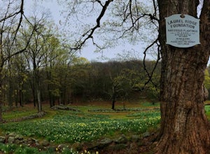
Photograph Daffodils at Laurel Ridge
Laurel Ridge is a private owned Farm , the owners are generous enough to let people visit these flowers so please be respectful of there rules. You may see the Daffodils from Sunrise-Sunset and usually fully bloomed Early April-May. Laurel Ridge is the perfect way to start Spring, the smell and ...Read more

