Brisbane, California
Looking for the best running in Brisbane? We've got you covered with the top trails, trips, hiking, backpacking, camping and more around Brisbane. The detailed guides, photos, and reviews are all submitted by the Outbound community.
Top Running Spots in and near Brisbane
-
Mill Valley, California
Miwok, Marincello and Bobcat Trail
8.17 mi / 1391 ft gainMiwok, Marincello and Bobcat Trail is a loop trail that takes you by a river located near Sausalito, California.Read more -
Moss Beach, California
Cypress Tree Tunnels at Moss Beach
4.50.79 mi / 105 ft gainThe Cypress Tree Tunnels are a quick jaunt from San Francisco (22 miles) and make for a great half-day trip. Getting here depends on traffic, but 30 minutes from the center of the city is doable. Parking is relatively easy. You can either park at the south end of the area at the Cypress Cove entr...Read more -
Moss Beach, California
Pillar Point Bluff Loop
4.71.84 mi / 154 ft gainSitting on a 140 acre bluff top, the Pillar Point Bluffs are a simple, easy hike with breathtaking views throughout. The bluffs are 22 miles from San Francisco – a 30 minute drive depending on the traffic. There is a small 10 car or so parking lot off of Airport Blvd, but there are two additional...Read more -
Tiburon, California
Angel Island Perimeter Loop
5.98 mi / 794 ft gainAngel Island Perimeter Loop is a loop trail around the circumference of the island in the San Francisco Bay. The island is located near Tiburon, California with views of downtown San Francisco, Alcatraz, the Golden Gate Bridge, Oakland, Sausalito, and TIburon as you traverse around the island. ...Read more -
Mill Valley, California
Coyote Ridge Loop
5.06.15 mi / 1001 ft gainStarting just before the Tennessee Valley parking lot, head out from the Miwok Trailhead. This Mill Valley hike offers incredible views of the San Francisco Bay, the Pacific Ocean (fog permitting of course!), and on occasion, wildlife. Unfortunately, this trail is not dog-friendly. Keep in mind...Read more -
Oakland, California
Hike Redwood Regional Park via the Dunn Loop
5.03.6 mi / 606 ft gainThe Redwood Regional Dunn Loop is just outside of Oakland, and can be reached from anywhere in the Bay Area for a fun day or half-day trip. The trail is open year-round. In the spring, wildflowers are abundant. The trail has a great mix of sun and shade. Dogs are allowed, but must be kept on leash.Read more -
Berkeley, California
Stonewall Panoramic Trail
4.51.44 mi / 663 ft gainFrom the trailhead at Stonewall Road, the 1.5-mile trail makes for an excellent before or after-work run. But the steep hills and loose ground aren’t for those looking to find an easy nature walk. The incline starts well before the Stonewall-Panoramic trailhead, so you won’t even have time to w...Read more -
Redwood City, California
Hike the Pulgas Ridge Open Space Preserve Loop
3.75.5 mi / 1000 ft gainGetting there: exit Highway 280 at Edgewood Road, travel .75 miles east, turn left on Crestview Drive, then immediately left again on Edmonds Road.Once parked, there are several different path options through the park. All of them connect in a large loop, and return to the parking lot. The Cordil...Read more -
Oakland, California
East & West Ridge Loop
4.53.47 mi / 833 ft gainTucked away in the hills of Oakland, you will find one of the homes of California's Coastal Redwoods. Created by a unique geographical circumstance, this forest breathes winds funneled through the Golden Gate across the bay, which created environment opportune for Redwood growth. These Redwoods a...Read more -
Muir Beach, California
Owl Trail
5.01.2 mi / 300 ft gainThe Owl Trail runs between Slide Ranch and the Muir Beach Overlook and is a great way to take in the breathtaking views, flora and fauna of the Northern California coast. The easiest way to access the trail is to park at the Muir Beach Overlook and to take the trail down to Slide Ranch and then...Read more -
Oakland, California
Run the Circumnavigation of Redwood Regional Park's Ultimate Trail Loop
5.07.5 mi / 1600 ft gainIt’s difficult to have a car in San Francisco, but oh-so worth it when it comes to weekend getaways, especially with all the Bay Area has to offer. This is a super accessible trail system just 30 minutes outside of the city that makes for a fun, easy trail run or hike.Redwood Regional Park, part ...Read more -
Redwood City, California
Hike Purisima Creek Redwoods OSP
4.67 miThere are two places to park for this specific loop- the main parking area on Highway 35 (Skyline Boulevard) and a smaller parking lot on the western end of the park. I would recommend parking at whichever is closest. Find directions to both on Openspace.org. From the main parking lot, the trail ...Read more -
Tiburon, California
Bouldering at Ring Mountain
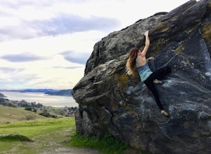
0.5 mi / 400 ft gainItching to climb outdoors near San Francisco? With only a quick drive from the city, Ring Mountain is a beautiful nature preserve overlooking the city of San Francisco offering two main rock formations, Turtle Rock (Pictured) and Split Rock. Split Rock is the slabby rock south of the parking ar...Read more -
Half Moon Bay, California
Half Moon Bay Coastal Trail
3.64 mi / 322 ft gainHalf Moon Bay Coastal Trail is an out-and-back trail where you may see local wildlife located near Half Moon Bay, California.Read more -
Berkeley, California
Seaview and Big Springs Loop
4.54.28 mi / 1007 ft gainThe trail is dog and horse friendly, and many trail loops make Tilden Regional Park fun for families and those of any skill level. The Seaview and Big Springs Trail loop is typically used by avid hikers, trail runners, or mountain bikers. The first half of the trail is exposed to the sun and rock...Read more -
Corte Madera, California
Ring Mountain Loop
4.02.65 mi / 597 ft gainRing Mountain Open Space is an easy but uphill trail that take you to the top where you can explore more trails. Take the 101 exit for Paradise Dr in Corte Madera, follow the road, and park on the side of the road once you pass Westward Dr. Even though there are many places to start the trail fo...Read more

