Alpine County, California
Looking for the best hiking in Alpine County? We've got you covered with the top trails, trips, hiking, backpacking, camping and more around Alpine County. The detailed guides, photos, and reviews are all submitted by the Outbound community.
Top Hiking Spots in and near Alpine County
-
Markleeville, California
Backpack to Grouse Lake
4.711.43 mi / 2283 ft gainIt is a 6 mile hike to Grouse Lake. You begin at the trailhead which is right by Damsite Campground at Upper Blue Lake. Park in the dirt parking area and then cross the metal footbridge, and you will see the trailhead marker on your left. The trail takes you into the Mokelumne Wilderness. Follow...Read more -
Arnold, California
Climb Lookout Peak in the Carson-Iceberg Wilderness
5.04 mi / 1900 ft gainLookout Peak in the Carson-Iceberg Wilderness off Highway 4 provides solitude and wonderful views of the surrounding Sierra Nevada including the Mokelumnee and Emigrant Wildernesses. Even on summer weekends you'll likely have the peak and surrounding area all to yourself.Lookout Peak can be done ...Read more -
Arnold, California
Climb Peep Sight Peak in the Carson-Iceberg Wilderness
7 mi / 1800 ft gainPeep Sight Peak in the Carson-Iceberg Wilderness off Highway 4 provides solitude and wonderful views of the surrounding Sierra Nevada including the Mokelumnee and Emigrant Wildernesses. Even on summer weekends you'll likely have the peak and surrounding area all to yourself. Peep Sight Peak can b...Read more -
Arnold, California
Hike To Bull Run Lake
4.3The hike to Bull Run Lake is about 7.8 miles, roundtrip, and begins at the Stanislaus Meadows Trailhead, located about 10 miles West of Ebbetts Pass. There is plenty of parking near the trailhead, off of the South side of CA 4. The trailhead GPS coordinates are: N38 30.376' / W119 56/617'Once you...Read more -
Arnold, California
Upper Gardner Meadow via Highland Lakes Trail
3.96 mi / 364 ft gainUpper Gardner Meadow via Highland Lakes Trail is an out-and-back trail where you may see wildflowers located near Markleeville, California.Read more -
Arnold, California
Backpack To Wheeler Lake
5.07.8 mi / 1000 ft gainThe trail to Wheeler Lake begins at the Woodchuck Basin Trailhead. This trailhead is located a little over a mile east of Lake Alpine on Highway 4. The trail starts off relatively flat and winds through forests and meadows, taking you into the Mokelumne Wilderness. Time it right and you'll be met...Read more -
Alpine County, California
Hike to Round Top Peak
5.09 mi / 1821 ft gainThis hike begins at Carson Pass which is accessible from Highway 88. The trail leaves from the parking lot (parking requires a fee of $5) and is easy to follow. After about a mile, you'll pass Frog Lake on the left, which is a nice place to stop for a quick snack.Continue along the trail and stay...Read more -
South Lake Tahoe, California
Meiss and Round Lake via Tahoe Rim Trail
10.5 mi / 1257 ft gainMeiss and Round Lake via Tahoe Rim Trail is an out-and-back trail that takes you by a lake located near Kirkwood, California.Read more -
Alpine County, California
Hike The Sisters in the Mokelumnee Wilderness
8 mi / 2500 ft gainThe Sisters offer a great day hike with fun scrambling and beautiful views of the Northern Sierra, Lake Tahoe, the Mokelumnee Wilderness, and the Carson River Canyon.The trail to The Sisters begins at Woods Lake (38.6855° N, 120.0095° W), at the end of Woods Lake Road off Highway 88, 1.5 miles we...Read more -
Alpine County, California
Hike Round Top Summit and Winnemucca Lake Loop
6.6 mi / 1272 ft gainThis hike begins near the Woods Lake campground. Start off by hiking towards Winnemucca Lake. You will begin your journey going through the forest beside a crystal-clear stream. Soon the trail opens up to become more open, full of all colours of wild flowers. You follow this breathtaking trail up...Read more -
Markleeville, California
Caples Lake to Emigrant Lake
5.08.71 mi / 971 ft gainThis is an awesome out-and-back hike for the weekend warrior. The trail begins at the western-most point of Caples Lake, and takes you to Emigrant Lake. The first 2/3 of the trail is rather flat and appropriate for all skill levels. The last mile up to the lake schleps up the hill, and has some ...Read more -
Pioneer, California
Hike to Granite Lake
Take the road to Kit Carson Lodge. When the road turns to dirt, take this one-lane dirt road as far as you can go. The road terminates into a round parking area, however, as of the writing of this post, there was a large tree blocking the road about 250 ft before the end.The Trailhead is clearly ...Read more -
South Lake Tahoe, California
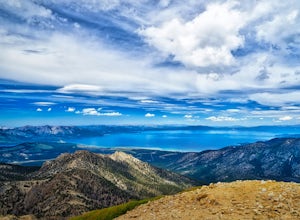
Hike to Freel Peak
5.07.3 mi / 2474 ft gainMt. Tallac may be one of the Lake Tahoe Basin's most famous peaks to hike because of its fantastic views of Lake Tahoe, but my personal favorite view in Tahoe is from the top of Freel Peak or Jobs Sister. Freel Peak is the tallest peak in the Lake Tahoe Basin at 10,881 feet.From the top of Freel...Read more -
Pioneer, California
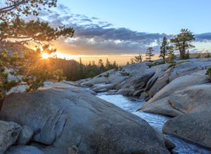
Camping at The Pots
4.2This fantastic camping or chilling spot has beautiful granite pools and slides of all sizes. The area consists of a river flowing over a granite slab creating pools some of which are over ten feet deep. The water cascades down the granite in small water falls. The area is located next to Silver L...Read more -
Arnold, California
Hiking Disaster Creek
While this is not a terribly scenic hike, the trees, creek, and terrain are very beautiful, and the entire area is quiet and peaceful. You're likely not to pass a single other person on the hike, which is great for letting dogs off-leash.The trail starts off with a series of switchbacks, which ga...Read more -
Amador County, California
Hike to Thunder Mountain at Carson Pass
7 miThe trailhead begins on Rt 88 just past Kirkwood Resort or Silver Lake - depending on which way you are headed. There is plenty of parking but no other amenities. The trail begins at 7,900 ft and climbs steadily up Two Sentinels then along the ridge to Martins Point, ending at the 9,408ft summit ...Read more

