
Hike to Summit of Mount Bealey
Arthur's Pass, New Zealand
Details
Distance
5 miles
Elevation Gain
3608.9 ft
Route Type
Out-and-Back
Description
Added by Ryan Mazure
This is one of the best day hikes in the Arthurs Pass National Park. Amazing views the whole way to the summit and you'll wish you could spend the night.
The hike to Mount Bealey starts in the town of Arthurs Pass at 750m above sea level. Take the road back towards Christchurch from the centre of the village and you'll cross a river, take the first right and head up Mount Bealey Road until you see a car park on the right hand side.
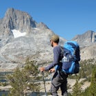
From here the hike begins through the beautiful shaded forest with glimpses out to the many waterfalls cascading down from higher up on the mountain. The summit is hidden from view but you are teased with what appears to be the top, looking ever so close yet so far away. There are a few amazing lookouts and Arthurs Village is always in view.
To reach the tree line takes around 1.5-2 hours and once you reach here there is a sign saying only experienced people to proceed. The sign has some truth and in cloudy/whiteout conditions you would really need to be a good navigator as it's very easy to get lost up here. It is absolutely essential to remember where you exited the bush from as once you get higher up it's very easy to take a wrong turn and end up no where near where you intent to be. In saying that there are some cairns to mark the way and experienced hikers should be fine to find the way back.
Around 30 minutes after exiting the bush the real fun begins. The trail turns into a ridge with medium sloped drops away to either side. The views from here are spectacular and you will have take a rest to take it all in. The ridge flattens out and the final 20 minutes are a steep scramble over loose scree and brittle rock. The rock is in really bad condition so check the holds before pulling too hard on them. The summit opens up and there is a 100m flat section to the true summit. To the west is unknown peak beckoning as it rises sharply from the col. In good conditions it's possible to do the alpine loop and link up Mount Bealey with Avalanche Peak or it can be attempted with an overnight camp up in the mountain.
The way back is the pretty monotonous and the steep trail through the bush is hard going on the knees. In the rain this trail would be a nightmare so keep that in mind.
A round trip will take you around 5 hours with a 30 minute summit break and 3.5 to 4 hours if you are cranking the burners. An amazing day out with some of the best views that the Arthurs Pass region has to offer.
Download Outbound mobile app
Find adventures and camping on the go, share photos, use GPX tracks, and download maps for offline use.
Get the appFeatures
Hike to Summit of Mount Bealey Reviews
Nice write up. Looks like you stopped at Pt. 1760, known as the Low Peak of Bealey. The true Summit of Mt Bealey is what you called the unknown peak to the west, 1836 meters high.
5.0
Leave No Trace
Always practice Leave No Trace ethics on your adventures and follow local regulations. Please explore responsibly!
Nearby

Winter Mountaineering in Arthur's Pass

Backpack to the Waimak Falls Hut

Hike up Avalanche Peak

Backpack to Lake Mavis

Hike to Devils Punchbowl Falls, Arthur's Pass

Hike the Temple Basin Ski Field
Discover
Community
Mobile Apps

© 2026 The Outbound Collective - Terms of Use - Privacy Policy