
Hike to the Top of Table Rock
Colebrook, New Hampshire
Details
Distance
1.52 miles
Elevation Gain
715 ft
Route Type
Out-and-Back
Description
Added by Hillary + Matt
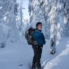
According to hiking enthusiasts, Table Rock in Dixville Notch, New Hampshire is one of the most exciting and thrilling hikes in the state. After about an hour hike the views of the White Mountains and the winding roads below are one of a kind.
Though the trail may seem a bit daunting at first (especially for beginners), this out-and-back hike isn't all that difficult. At the trailhead (located almost directly behind the sign "Entering Dixville Notch State Park"), you'll begin by walking through some densely wooded forest. The trail is pretty steep and requires a bit of finesse as there are a lot of fallen branches and limbs across the path. The trail is roughly a half-mile's walk to the summit.
An alternate route can be found on Route 26 east of the junction with the access road to The Balsams/ Wilderness Ski Area. The trail starts before the yellow road sign and is well-marked, though a bit longer.
Once you reach the summit, the vistas are pretty spectacular. Below you is the small community of Dixville Notch, famous for its midnight elections at The Balsams (which you'll get an aerial view of if you're brave enough to look over the edge!). There's an almost vertical 700-foot drop off Table Rock, so be careful of how close to the edge you get. While we exited the way we came, there is an alternate route that connects with the white-marked Appalachian Trail and takes hikers to Baldplate Mountain, then back to the parking area.
Tips:
- There is no clearly defined parking area, but most cars pull off on the shoulder of Route 26 near The Balsams.
- Since you'll be trekking through dense trees and foliage, make sure to thoroughly check yourself for ticks once you're finished.
- Make sure to check the weather before you go. Because this is a relatively steep climb (and there's no protection at the summit), the rocks and fallen leaves can get pretty slippery when wet. There's also a lot of loose gravel and unsteady ground in some parts that can result in some serious injuries if you slip and fall. Play it safe.
Download Outbound mobile app
Find adventures and camping on the go, share photos, use GPX tracks, and download maps for offline use.
Get the appFeatures
Hike to the Top of Table Rock Reviews

Table Rock is no where near the Appalachian Trail. Dixville Notch is an hour+ north of the AT.
3.0
This is definitely a "bang for your buck" hike. Hikers are rewarded with beautiful 360 views for a relatively short hike. An awesome hike in the fall as the leaves approach peak!
5.0

The sign at the trail head calls the hike a climb, I would call it a scramble. We opted for the "straight up the hillside" trail v the less vertical trail across from Basalms. It took about 30 minutes to summit, lots of verifying hand holds and foot placement before committing to the step. The shale made going down a little sketchy in places. The summit was worth the short climb, stunning 360° views. Enough space to sit and enjoy for several small groups. We weren't planning to hike the day we came across the trail, so I wore jeans and tractionless minimalist tennis shoes. A flexible approach shoe would be recommended.
5.0
Leave No Trace
Always practice Leave No Trace ethics on your adventures and follow local regulations. Please explore responsibly!
Nearby

Fly Fish Lower Dam at Rapid River, Maine

Table Rock Trail

Hike Eyebrow Trail to Old Speck Mountain Loop

Hike Bald Mountain in Rangeley

Hike to Fourth Connecticut Lake

Photograph Screw Auger Falls
Discover
Community
Mobile Apps

© 2026 The Outbound Collective - Terms of Use - Privacy Policy