
Emily Schrick

Hike the Arastradero Preserve Loop
Palo Alto, California
3.0
4.5 mi
/ 600 ft gain
Getting There:
From Hwy 280, take the Page Mill Road exit and head West on Page Mill Road, away from Downtown Palo Alto (if you're taking 101, exit on Oregon Expressway). Then turn right on Arastradero Road. There will be a small sign indicating the dirt parking lot on the eastern side of the street. Note that parking is not allowed on the street.
The Hike:
There are many trails in the preserve...

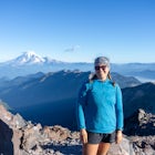
Hike to the Top of Andesite Peak
Soda Springs, California
5 mi
/ 1000 ft gain
From the trail map sign, follow the dirt path straight, following signs for the cross-country skiing route, not snowmobiling. Continue until you see a trail marker. You'll veer left to head over to the Hole in the Ground trail. Once you see another identical trail map board, you'll head left. This is the official start of the Hole in the Ground trail, about 1 mile from where you parked your car...

Spencer Butte Loop
Eugene, Oregon
4.5
1.6 mi
/ 564 ft gain
Getting There
Searching Spencer Butte Trailhead Parking Lot on Google Maps will direct you to exactly where you need to go. From downtown Eugene/ UO you'll drive south on Willamette St. until you see an official park sign for Spencer Butte Park. Take a left on the gated road (will be locked during closed hours - around 9 pm to 6 am), and drive up to the large parking lot. There is room for abo...

Camp at Wawona in Yosemite National Park
Mariposa County, CaliforniaWawona offers over 90 campsites in 3 loops, including 1 group site, 2 horse sites, and RV/ camper access.Every loop has at least 1 bathroom with flush toilets, but keep in mind that there are no showers at this campground.Pets are allowed, but must be kept on leash at all times.Each campground contains a fire pit, bear-proof food locker, and picnic table. This campground doesn't offer the best ...

Hike San Mateo's Sugarloaf Mountain
Belmont, California
5.0
1.5 mi
/ 500 ft gain
Sugarloaf is tucked away in Laurelwood Park which is located in a residential neighborhood right off of Hwy 92 in San Mateo, making this a great hiking & trail running option for Peninsula residents.I always park on Glendora Dr. and follow the paved path down towards the playground. At the bottom of the hill you'll see a trailhead sign with some options for proceeding up the mountain. Thoug...

Kayak Mendocino's Big River
Mendocino, California
4.8
The Big River estuary in Mendocino Headlands State Park is one of those best of both worlds scenarios where dense Redwood forest and fresh, lazy river water meet rocky beaches and the mighty Pacific. If you're really lucky, you can swim with river otters and harbor seals at the same time. Paddle up the river and pull over to explore the Redwood forest - there are plenty of small trails winding ...

Pothole Dome
Wawona, California
5.0
1.01 mi
/ 250 ft gain
Getting There
From the Tuolumne Meadows Visitor Center, head west on Tioga Road/ Hwy 120 towards Tenaya Lake. You'll only travel about 1 mile down the road until you see Tuolumne Meadows open up again on your right, and there will be a very large gravel pull out where you can park. Pothole Dome will be the prominent rock rising from the meadow.
The "Hike"
Looking out at the meadow, continue...
Community
Mobile Apps

© 2024 The Outbound Collective - Terms of Use - Privacy Policy