
Waterdog Lakes Trail
Salida, Colorado
Rated 5.0/5
based on 1 reviews
5.0/5
Details
Distance
3.2 miles
Elevation Gain
1056 ft
Route Type
Out-and-Back
Description
Added by Outbound
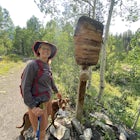
Waterdog Lakes Trail is an out-and-back trail that takes you by a lake located near Salida, Colorado.
Download Outbound mobile app
Find adventures and camping on the go, share photos, use GPX tracks, and download maps for offline use.
Get the appFeatures
Fishing
Snowshoeing
Hiking
Dog Friendly
Waterdog Lakes Trail Reviews
Leave No Trace
Always practice Leave No Trace ethics on your adventures and follow local regulations. Please explore responsibly!
Nearby

Ride the Monarch Crest Trail
The Monarch Crest Trail has been rated as an IMBA Epic ride and is for sure an epic ride especially ending the ride with the Rainbow Trail. The Monarch Crest Trail is best ridden as a shuttle and begins at the very top of Monarch Pass just outside of Salida or Poncha Springs, Colorado on highway U.S. 50. The High Valley Shuttle service offers two shuttles a day at 8am and 10am for for a fee and...

Hike Mount Shavano and Tabeguache Peak
Start out on the Shavano and Tabeguache Trailhead off of FR 252 outside of Poncha Springs, at about 9,700 feet, and begin your trek into the forest. In the first half of a mile there are a few trail marker signs that should be read carefully to insure the right path is followed, but these signs are very easy to understand, and getting off track is hard. After this half mile, there is only one...

Explore the St. Elmo Ghost Town
If you're willing to go off the beaten path to a neat little ghost town, St. Elmo, Colorado is the place for you! About 2 and a half hours west of Colorado Springs, Colorado lies the town of St. Elmo, high up in the White River National Forest.The town itself was founded in 1880 when they discovered gold and silver in the area but slowly began to decline in the 1920's as the mining industry de...

Roosevelt Mine
Abandoned in 1919, Roosevelt Mine is a lost treasure of Gunnison County, Colorado. Exactly three miles outside the tiny town of Ohio City is the unmarked trailhead on the side of a road pull off for Roosevelt the mine. The trail is otherwise well established and easy to follow. The trail is a little more than a half mile long and boasts amazing views of both the surrounding mountains and Quartz...

Browns Creek Falls via Wagon Loop Trail
This scenic route to Browns Creek Falls is a standout mountain-day-hike in the Colorado Rockies—moderate in length, strong on payoff, and rich in variety. Starting from a forested trailhead, you’ll climb through pine and aspen forest, follow Browns Creek, and eventually arrive at a dramatic, year-round waterfall nestled beneath towering peaks.
Trail Basics & What to Expect
Terrain...

Mount Antero via Wagon and Little Browns Creek Trail
The Mount Antero via Wagon and Little Browns Creek Trail offers an epic alternative route to summit one of Colorado's magnificent 14ers (14,269 feet). This challenging trail provides a true wilderness experience away from the crowds, taking you through lush woodlands, aspen groves, and dramatic alpine terrain for an unforgettable Colorado hiking adventure.
Trail Overview
Starting Elevat...
Discover
Community
Mobile Apps

© 2026 The Outbound Collective - Terms of Use - Privacy Policy