
Hike and Camp at Mt. Arrowsmith
Errington, British Columbia
Description
Added by Dan Duerden
Distance: 6-7 km (4 miles) roundtrip. Elevation gain: 1,000 m (3,280 ft). The highest mountain on the southern half of Vancouver Island. Easily accessible alpine camping with breathtaking views. Accessible to many skill levels. Several objectives for varying degrees of difficulty.
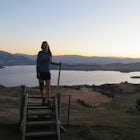
Mt. Arrowmsith's claim to fame is the tallest mountain on "southern" Vancouver Island. Standing at 1,819 m (6,000 ft), it barely squeezes into the top 50 of the Island, as it stands no chance against the peaks of Strathcona, which you can see gazing north from the summit!
The advantage of Arrowsmith is it's closer proximity and variety. There are a multitude of routes and access points, and with it's many "bumps" around the true summit, there are plenty of places to explore!
The most common route is the "Judge's Route.” Off the #4 Highway, turn left onto the Cameron Main, and continue for 13 km (8 miles) until you reach Pass Main. The trailhead is marked by a large spray-painted boulder with a large yellow gate behind, about 3 km (1.8 miles) up Pass Main. The parking area is just past the boulder and gate in quite a large, obvious wash-out.
Hike up along the logging road until you get to the first switchback and continue into the trees. Stay on this older road until you see flagging at the very end of the road. From here, the route is well flagged to the summit.
For the more adventurous route, drive up Pass Main for 7.3 km (4.5 miles) to Spur 37, where you access the well-flagged saddle route between Mt. Cokely and Arrowsmith.
From here, it's a sharp climb up about 300 m (985 ft), you will find a couple of sections with rope aids, which are not necessary for the most part. After the scramble gets your blood going, you will open up out of the valley and onto the saddle itself. Head up to the right of the saddle and pick the best campsite. This is wilderness camping, so remember to practice no-trace.
If you choose to do this as a day hike, continue through the saddle towards the bumps. Note that they are almost as high as the true summit, giving you plenty of options for turn-around points, depending on your group and time-frame.
The bumps begin as a Class 3 scramble with well laid out goat tracks – some route finding is needed here. Once you're through the minor bumps along the ridge you approach the Nose, which is a Class 4 with a low Class 5 pitch. Either bring gear to rappel, making use of the excellent bolted belay/rap stations in place, or you can descend via Judge's Route and walk the road 4.3 km (2.7 miles) back to the saddle trailhead.
Other routes of note that are worth researching if you enjoy Arrowsmith: Main Snow Gully Ascent, Lost Gully and Un-Judges.
Download Outbound mobile app
Find adventures and camping on the go, share photos, use GPX tracks, and download maps for offline use.
Get the appFeatures
Hike and Camp at Mt. Arrowsmith Reviews
I love all the trails up here. If you choose to drive up, use caution.
5.0
Leave No Trace
Always practice Leave No Trace ethics on your adventures and follow local regulations. Please explore responsibly!
Nearby

Winter Climbing Mount Arrowsmith

Summit Mount Cokely

Summit Mt. Cokely via the Historic CPR Trail

Cathedral Grove

Hike Little Qualicum River and Falls

Hike to Hole in the Wall
Discover
Community
Mobile Apps

© 2026 The Outbound Collective - Terms of Use - Privacy Policy