
Hike the Glory Hole Falls Trail
Jefferson Township, Arkansas
Details
Distance
2 miles
Elevation Gain
345 ft
Route Type
Out-and-Back
Description
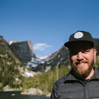
Added by Kevin Abernethy
Enjoy beautiful scenery on this 2-mile hike to a one of a kind waterfall in Ozone, Arkansas.
This trail and waterfall is located 13.8 miles south of Boxley, AR or 5.7 miles east of Fallsville, AR. The easiest way to get to the trailhead is to locate the Cassville Baptist Church on your GPS system. If you are headed east, the church is 0.7 miles east of the trail. If you are headed west, the trail will be 0.7 miles after you pass the church. You will see a designated parking area on the south side of the road at the trailhead. If you have a 4WD vehicle you can drive about a quarter of a mile down the trailhead and park.
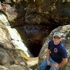
Once you are parked at the highway you will head south down the designated path to what eventually turns into an old downhill road. The path will cross the main creek at the bottom of the trail, this is the water source that feeds the waterfall and is known as Dismal Creek. The path will continue downhill and you will eventually see the bluff line of the waterfall. You can walk up and see where the water has created a hole through the rock, creating the "Glory Hole". The trail continues down on the west side of the bluff where you can walk underneath the rock to view the waterfall. I took this route in the winter and there were several ice patches so be careful, especially if you are on the bluff.
Plan to see the waterfall after a good rain, or in the winter to potentially see parts of the falls frozen. The hike to the Glory Hole is all downhill, there is a short elevation gain of 345 feet on your way back to the trailhead.
Download Outbound mobile app
Find adventures and camping on the go, share photos, use GPX tracks, and download maps for offline use.
Get the appFeatures
Hike the Glory Hole Falls Trail Reviews

Easy hike down to the falls. Watch for a possible American Indian trail tree a couple hundred yards from the start of the trail. Check out the falls from the top. We stopped and ate lunch at the bottom. Very unique waterfall, our favorite place in Buffalo River area. Also found a geocache on the way. Not as crowded. Family hike, kids 10 and up.
5.0

Definitely one of the most unique waterfalls I've ever visited. Great views from both the top and bottom. Passed it about 3 time before I finally saw the sign though!
4.0
A little difficult to find. But a cool area and unique waterfall. I made the mistake of going mid summer when the water wasn't really flowing
4.0

Easy hike to a dramatic waterfall. Great area near the waterfall to climb and explore!
5.0
I love this beautiful area. For lowest crowds go during the week. First time I went was middle of week and I only saw 6 people. Went on Good Friday last week and there were over 15 vehicles parked at trailhead, people were leaving trash and just generally not adhering to trail etiquette.
4.0
Leave No Trace
Always practice Leave No Trace ethics on your adventures and follow local regulations. Please explore responsibly!
Nearby

Hike to Magnolia Falls

Neil Compton's Double Falls

Backpack Along Whitaker Creek

Hawksbill Crag via Whitaker Point Trail

Hike Big Spring Trail

Hike to Sweden Creek Falls
Discover
Community
Mobile Apps

© 2026 The Outbound Collective - Terms of Use - Privacy Policy