
Yellow Aster Butte and Tomyhoi Peak
Whatcom County, Washington
Details
Distance
13.4 miles
Elevation Gain
4902 ft
Route Type
Out-and-Back
Description
Added by Alex Tande
A spectacular destination easily reached for a day hike or an overnight trip. Yellow Aster Butte and its tarns create a phenomenal place to spend some time. Amazing views, incredible sunsets, and just the right amount of physical exertion.
The best way to describe the location is due east of Bellingham. After driving through gorgeous roads to reach Twin Lakes Road (fire service road 3065), you are treated to about a 4-mile drive up to the trailhead for Yellow Aster Butte (8.3 miles RT with 2850' of gain) and Tomyhoi Peak. The drive contains beautiful river views and waterfalls as it climbs its way up to the trailhead. It can get busy, but overall parking is not difficult to find along the roadside.
The trail starts out by climbing, quite a bit. You gain the majority of the elevation within the first couple of miles. Take your time and enjoy the views that are already presenting themselves. Once you leave the side of the hill and turn inland, you enter into a lush forest that provides a flatter terrain and some shade if the sun is beating down. Working your way through the forest, there are a few places to set the pack down and relax. As you arrive to the crossroads of tracks, wander off the main track just a bit to soak your feet in a babbling brook as you eat lunch. The crisscrossing trails can add a bit of confusion. Explore as you please, but the main track is labeled clearly taking you on your way back up towards Yellow Aster Butte. As the track continues, the trail finishes the last of the forest and then continues to climb up through the valley.
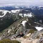
Cresting the last of the wooded area reveals the views of Baker and Shuksan seen across valleys and jagged snow-covered peaks. If you go during autumn, the alpine flowers will cover the foreground in reds, yellows, oranges, and purples. Keep trekking along an exposed alpine meadow. At times in early summer there still can be snow, so be prepared.
After cresting the last of the climb, there will be an unmarked junction that will differentiate between the day hikers and overnighters. If you are spending the night, descend a series of steep, narrow switchbacks down to the dozens of tarns that provide phenomenal tent sites. If you are day hiking, head up the last climb to reach the actual geographical feature called Yellow Aster Butte. After enjoying the stunning panoramic views, return the same way you hiked in.
The entire trip to the tent sites or the butte is a relatively easy hike in. Average fitness level required. As always, know your limitations. The intermediate hike comes into play if you are going to attempt Tomyhoi Peak.
Tomyhoi Peak is a great day hike from the tarns, making you work of the views you are treated to. Thomyhoi sits at about 7,400 feet elevation. The true peak requires some technical gear, including some climbing gear, and glacier walking gear. The trail up to Tomyhoi sits on the backside of the basin, rising steeply up the side towards the peak. Follow cairns until you see the track, and from there on, it is a well-defined foot path. From time to time, keep your eyes our for cairns. After the initial climb, it levels out slightly, but still gains altitude for just about the entire hike. There are times where it is totally flat, or even downhill. There are two points that do require a bit of a rock scramble, but nothing dangerous, totally feasible. There is a false summit partway up the ascent, don't give up! Keep climbing among the marmots and mountain goats to reach your goal. My crew and I made about 7,200 before deciding to turn back rather than risk the glacier walk. The views are truly spectacular, and you can get full 360 degree views of countless jagged peaks, snow covered mountains, Mt. Baker and Mt. Shuksan. The entire up and down trek (plus lots of pictures and lunch) took us the better part of the day, about 5-6 hours. Work the cardio on the way up, work the quads on the way down.
If you have the energy, attack one last hill to watch sunset. I was feeling pretty depleted after Tomyhoi, but managed to rally to scramble up one last hill. Trek out towards the far end of the tarns, towards Mt. Baker. There is one last unnamed peak snuggled among the last of the tarns that juts out drastically compared to the surrounding terrain. The hike up is a bit of a scramble, with a clear trail at times, and at others you pick the best way up. The top offers an entire 360 degree view of the sky lighting up with the best purples, blues, yellows, oranges, and reds. From the jagged peaks to the monstrosities that are Baker and Shuksan lighting up with color, you will not go wrong. Pick your way back to your tent and go to sleep with a smile on your face.
Tough it out to make it back to Bellingham, only about 2 hours, and enjoy a cold brew and delicious burger. There are tons of places to enjoy and re-fuel the body.
There have been reports of some heavy bugs in the area, but I have not encountered in my two times up there. In WA, there is usually a common occurrence of rain, so do be prepared, please check the weather! The trail is a popular one, so an organization called Washington Trails Association does a great job maintaining the trail, and the road and trail conditions are usually quite good.
Do enjoy!
PERMITS:
Download Outbound mobile app
Find adventures and camping on the go, share photos, use GPX tracks, and download maps for offline use.
Get the appFeatures
Yellow Aster Butte and Tomyhoi Peak Reviews

Hiked up to camp and explore among the tarns the first weekend in September. The road up to the trailhead was full of potholes, but only encountered a couple that would bottom out anything less than an SUV. Arrived at the trailhead around 8am with a few cars (looked to be overnight) and a couple of day-hikers that were strolling in as we departed. Saw only a few hikers on our way out - one pair heading down from an overnight and one couple heading up to stay the night with just a couple other day-hikers. We took our time, enjoyed the views and made it up in about 3 hours. One note, there are a lot of notes on sites speaking about a split to the left to get to the tarns for camping. You'll know you've arrived when you can look down into the valley and see the tarns. At that point, make sure you take the trail leading into the basin. We spent a couple days up there exploring around the tarns and hitting up some of the trails to the top. The stay was highlighted by one of the most incredible star-gazing experiences I've ever seen. Overall, a great trip and I highly recommend. You'll have some company during the summer and on a busy weekend, but for a bit of isolation, you can head out towards the Mt. Shuksan direction (south side of the basin) and find a hidden little spot to camp which isn't visible from most of the other parts of the basin. It also provides a nice rock for eating, Shuksan or Baker viewing, star-gazing, and just hanging out on throughout your trip.
5.0

Definitely one of the most stunning views in the Mt. Baker area. The bugs can be nasty in the summer while the wildflowers bloom and the road to get to the trailhead is rough and narrow and near impossible without a high clearance vehicle, but the hike is still one of my favorites. Honestly, I would do this hike much more often if my car could just get to the trailhead in one piece!
5.0
Hiked this Oct 24, 2015. Next year I'll go a month earlier to better enjoy the fall colours! Rough road driving in and easy to miss it! The road is a small side trail off a large operations parking lot (winter snow removal?) take this bumpy side road for 4.3 miles. I drove my honda civic with no issues, just took my time with the bumps and a couple awkward run ins with oncoming traffic as the road is quite narrow. It was a great hike, starts with some switchbacks, after an hour it opens up to give you some views of the mountains around you and you start the easier portion of the hike with less incline. Walking through more meadowy areas. We didn't quite make it to the top because we got a late start. After just over 2 hours we turned around. I would imagine we had about 20-30 minutes ahead of us yet. But the last 30 minutes of our hike gave us great views of Baker, Shuksan and more! We heard from others coming down that the top was similar views to what we were seeing. Bring a windbreaker, it's chilly up there. Going down was quick as usual, about 1 hour. Bathroom - it's there, I was advised to not use it and took their word for it. I plan to go back next year in September and allow more time for enjoying at the top!! :)
4.0
Leave No Trace
Always practice Leave No Trace ethics on your adventures and follow local regulations. Please explore responsibly!
Nearby

Yellow Aster Butte

Winchester Mountain Fire Lookout

Winter Hike to Winchester Mountain

Climb Ruth Mountain and Icy Peak

Catch a Sunrise at Picture Lake

Huntoon Point Backcountry Camping
Discover
Community
Mobile Apps

© 2026 The Outbound Collective - Terms of Use - Privacy Policy