
Mailbox Peak New Trail
North Bend, Washington
Details
Distance
10.53 miles
Elevation Gain
4127 ft
Route Type
Out-and-Back
Description
Added by Austin Johnson
Mailbox Peak New Trail is an incredible, but tough hike that offers fantastic views around the I-90 corridor near North Bend, and is within an hour's drive of Seattle!
*Disclaimer this article is in regards to the newly built trail.* For the old trail, head to Hike Mailbox Peak.
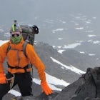
Just off of exit 34, Mailbox Peak offers a birds-eye view of the surrounding area. This hike begins at a mere 800 ft. above sea level and by the time you are done you are nearly touching the 5000 ft elevation. The elevation gain starts in the parking lot and it only gets steeper the higher you go up.
You begin the hike on the northwest face of the mountain and continue on that side under the cover of forest until you finally reach the last stretch of the hike. There are few views on the way up until you reach the talus fields in the last quarter mile of this adventure. When in the talus field beware, your hiking poles will not agree with the various rocks here.
Once at the top you have a 360º degree view of the surrounding area. Mt. Rainier is visible to the south and Mt. Baker, and Glacier Peak are both visible to the north while you have Chester Morse Lake, Rattlesnake Lake, and the Olympics to the west weather pending.
All around this is an incredible hike and its popularity shows it.
Download Outbound mobile app
Find adventures and camping on the go, share photos, use GPX tracks, and download maps for offline use.
Get the appFeatures
Mailbox Peak New Trail Reviews
Hello all, The following is a detailed report of my experience in the trail, a video of the hike that will show more details and updates can be found here: https://www.youtube.com/watch?v=mZ9ovksdlqI&t=398s Started my hike at 6:15Am there was only one other car in the parking lot. my plan was to hike up the old trail to the top and then back down the new trail that way it would be nicer on my knees. I kept a solid pace of about 2MPH and reached the top just after 8am. There was a fair amount of snow that started about 1mile up the old trail. Upon reaching the summit the wind was very very strong despite only calling for 5mph winds. I used Crampons at the summit they were not necessary, but they did help. At the base of the boulder field, I changed into my running gear and ran back to the trailhead via the new trail. got back to the cars at 9:30am and drove home again Turned around and hiked down, I would like to say that the video gives a very good description of the current conditions. https://www.youtube.com/watch?v=mZ9ovksdlqI&t=398sng -Zach
4.0

I hiked this in mid December after a period of no snow. There was still snow at the boulder field and above. I went up the new trail and down the old. It was only upon reaching the bottom (and losing the trail for a bit) that I saw all the warnings about getting lost at the old trailhead. Be careful! And watching the reflective diamonds on the tree. This hike is a great challenge with views to match.
4.0
Recently hiked this a few weeks ago and it was a good hike! First of you do need your discovery pass for parking as there is no where to pay if you forget it. As you head into the hike there is a lot of tree coverage and it starts of gentle. The incline was a burn and unfortunately we didn’t make it to the top due to the snow fall. I would recommend going on this hike in the summer months purely for better views and to be able to reach the peak. The new trail is a lot better but is still a pretty steep incline! Definitely not for beginners.
4.0
Hiked this route a week before November and found myself in snow from about 1/2 below the tree line all the way to the top. Check the snow reports before going and be prepared. The mailbox was still poking out above the snow though.
4.0
Leave No Trace
Always practice Leave No Trace ethics on your adventures and follow local regulations. Please explore responsibly!
Nearby

Mailbox Peak Old Trail

Twin Falls

Mount Washington

Drive Along the Middle Fork Snoqualmie River

Mount Teneriffe
")
Teneriffe Falls (Kamikaze Falls)
Discover
Community
Mobile Apps

© 2026 The Outbound Collective - Terms of Use - Privacy Policy