
Goat Rocks Wilderness
Randle, Washington
Description
Added by Ann Marie Bowlus
This moderate climb (2,000ft) is great for everyone! I went with a group of women ranging from 23-64 years old! From the ever impressive views of Mount Adams to a valley speckled with a variety of wild flowers it just keeps getting better. During our adventure, we saw over a half dozen mountain goats graze by Goat Lake, and dip our toes in the half frozen lake! Nothing better after a good hike than to give yourself a much needed ice bath.This hike is one for the bucket list!
This is the best description that I found and used during my trip from OregonHikers.org.
This is one of the best alpine hikes in Oregon and Washington - on your "must do list" for sure. The highest section of the hike, around Goat Lake, is snow covered until about late July, and is very exposed during bad weather so keep an eye on the weather reports. Also, consider taking mosquito repellent for this hike because bugs are numerous there in July and August.
Since it's so nice, this tends to get over-run, especially on summer weekends, so you might want to do a different hike then. And don't expect solitude. Craig Ramano article.
You can start at either the Snowgrass Flats Trailhead or the Berry Patch Trailhead, and you can go either clockwise or counter-clockwise. For this hike, we arbitrarily start at Snowgrass and go counter-clockwise. If you're going up and back on the Snowgrass Trail, it saves 0.4 miles to park at Snowgrass Trailhead rather than Berry Patch Trailhead. If you're doing the loop, it saves 0.4 miles to park at Berry Patch. There is a large area at Berry Patch to park with large trees to the south so you get better shade for your car.
The Snowgrass Trail to Snowgrass Flats can be extremely busy on summer weekends - expect to pass 20 groups of people, but don't worry, at Snowgrass Flats several trails fan out in different directions so the people start thinning out.
From the Snowgrass Flats Trailhead, you start on the Snowgrass Hiker Trail (#96A) which ends at mile 0.2 where it joins the Snowgrass Trail (#96). The Berry Patch Trailhead is left 0.6 miles. Stay right on the Snowgrass Trail.
At mile 3.7 is the junction with the Snowgrass By-pass Trail (#97) which goes right. Stay left on the Snowgrass Flat Trail (96). The By-pass trail takes you up to the Pacific Crest Trail which goes south to Cispus Pass, which would make a good alternate hike. There are many nice campsites along this route.
At mile 4.9 is the junction with the Lily Basin Trail (#86), which goes left, which is where we want to go. This is the beginning of the Snowgrass Flat area which contains many nice campsites and a stream for drinking water a short distance to the right (southeast). A good alternate hike would be to continue on the Snowgrass Trail, up to the PCT, and then north to Old Snowy and PCT Summit, which is the highest section of the PCT in Washington.
Following the Lily Basin Trail, in the next 1.5 miles, are about 10 of the nicest campsites you've ever seen (Goat Lake to Snowgrass). You get great views of Goat Rocks and Goat Ridge above you to the north and east, and great views south and west towards Mount Adams and Mount St. Helens. There are a number of streams for drinking water that cross the main trail. Whenever you see a short side trail, it probably goes to a campsite. Fires are allowed, and there are enough trees around for firewood, but keep this to a minimum to reduce impact.
At about mile 5.5 is an unmarked sidetrail that goes up to the PCT, Old Snowy, and Elk Pass.
At anywhere about mile 6.5 you can go off-trail, up to Goat Ridge, and then follow it up to the PCT and Old Snowy, but this route can be fairly difficult, especially towards the top, where there are difficult rocky slopes. You encounter some tarns, and nice campsites, away from other people.
At mile 7.4 is Goat Lake. The mile before and after is the most alpine, most exposed, last to be free of snow section of the hike. Great views. It's too steep for camping except at Goat Lake, where there are about 6 camp spots, but it's so exposed that it's not the best. If you do camp there, make sure and keep your stuff tied down or it will blow away.
Keep your eyes open and expect to see mountain goats on the ridge above you (Goat Ridge).
At mile 8.2 is the intersection with the Goat Ridge Trail (#95). This is the highest point of this loop at 6,650 feet. The Lily Basin Trail continues steep ascent to the right, along alpine areas and would make a good side trip. In about 0.5 mile, that trail reaches the crest of Goat Ridge. You can then follow the ridge on a primitive trail to Hawkeye Point which overlooks Goat Lake. You can continue on the Lily Basin Trail to other nice alpine areas. This goes even a bit higher than Goat Lake, and there are north facing slopes, so expect to see snow even later, even all year.
For this Goat Lake Loop Hike, stay left on the Goat Ridge Trail. The trail looses about 300 feet elevation in the next 0.5 mile where it joins a stream through Goat Ridge Meadow. There are several nice campsites near here. One inviting place is next to a tarn a ways off the trail to the west. This area would be much less exposed than camping at Goat Lake, and probably fewer people.
At mile 9.1 is the intersection with the Goat Ridge-Jordan Creek Trail Junction|Jordan Creek Trail (#94)]]. This trail is frequented by horses. It goes down to a trailhead you passed on Road 21.
Continue down the Goat Ridge Trail to it's beginning at the Berry Patch Trailhead at mile 12.0.
Presuming you parked at Snowgrass Flats Trailhead, take the Snowgrass Trail (#96) to the junction with the Snowgrass Hiker Trail (96A) at mile 12.6, and turn right to get to the trailhead at mile 12.8.
Download the Outbound mobile app
Find adventures and camping on the go, share photos, use GPX tracks, and download maps for offline use.
Get the appFeatures
Goat Rocks Wilderness Reviews
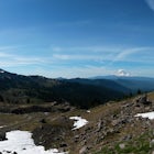
I went with a group of women (all ages! 23-64!). The views just keep getting better the higher you climb. We camped at Goat Lake, and there was plenty of room for our large group and three other friendly backpackers. Most of the snow had melted and we had more than enough access to water and shady spots to rest in. If you are looking for a moderate climb (2,000ft elevation gain up to 6,000ft) this is the place for you! The views of Mt. Adams alone are reason enough to put this hike on your bucket list! Not to mention, the valley and ridges you climb are speckled with wild flowers and your friendly mountain goats!
4.0
Leave No Trace
Always practice Leave No Trace ethics on your adventures and follow local regulations. Please explore responsibly!
Nearby

Hike to Elk Pass via "the Knife"

Hike to Goat Lake, Goat Rocks Wilderness

Goat Lake-Jordan Basin Loop

Summit Old Snowy Mountain

Surprise Lake via South Fork Tieton Trail

Backpack the Snowgrass Flats, Cispus Basin, Nannie Ridge Loop
Community
Mobile Apps

© 2024 The Outbound Collective - Terms of Use - Privacy Policy