
Spy Rock via Cash Hollow
Tyro, Virginia
Details
Distance
5.71 miles
Elevation Gain
1191 ft
Route Type
Out-and-Back
Description
Added by Christin Healey
The views from Spy Rock are simply breathtaking. It's a short hike, but from the top you can see the Religious Range: The Priest, The Little Priest, The Friar, The Little Friar, and The Cardinal.
The hike is part of the George Washington National Forest, and can easily be combined with nearby Crabtree Falls (300ft cascading waterfall with a hike to the top). The entire trip is 5.7 miles, and there are nice campsites at the base of the summit (no water source) if you want to add on this pretty overlook to a nearby longer hike. This is definitely a hike for locals, so it's never too crowded despite having probably the best views of the Blue Ridge around. The spring and fall are the best time to see the flowers and the fall foliage.
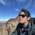
There is an easy scramble to get to the top, but my small lab made the journey with no problems if you want to bring your pup. This could be a sunset or sunrise hike, but the views to the west are slightly better looking into the valley.
This trail is dog friendly.
Note: Please refrain from hiking on private land near the Montebello State Fish Hatchery. There is a secure gate adjacent to the fish hatchery denoting private land and blocking access to the AT. Please access Spy Rock via Cash Hollow to stay on public land and avoid any issues of trespassing. The pin in the driving directions will lead to the Cash Hollow starting point.
Download Outbound mobile app
Find adventures and camping on the go, share photos, use GPX tracks, and download maps for offline use.
Get the appFeatures
Spy Rock via Cash Hollow Reviews
Started at around 10am on a Friday. Parked at the trailhead. Saw 3 people on the way up and no one on our way back. I would consider this hike moderately strenuous buuuut I also did this hike at almost 8 mos pregnant. I think even without the extra passenger this hike still would have required a solid effort but very doable either way. Decent amount of incline but sections of flat ground to break up the ascent. I brought my 1yr old Weimaraner along and she enjoyed every step. Clocked 2h 59min of active hiking and 5.83mi total.
5.0

Nice combination when paired together. If you're in the GWNF, I'd put this on your list.
5.0

Private road from fish Hatchery to National Forest is closed to general public. Use Meadows Lane road to cash hollow road to approach spy rock from the north. Once you get on Meadows Lane road (towards Crabtree Meadows), reset your odometer. You will cross a stream at .5 and 1.2 miles (low clearance sports cars not recommended). At 3.1 miles look for a 4WD on the right (cash hollow road). Park in one of the camping spots and hike up this road past a Forest service gate to the AT trail. Head south (right) to spy rock. This route is about 5 miles round trip. Should take about an hour each way. Email me if you want more info at Spyrock@mac.com
5.0
My husband and I hiked this beauty with our medium sized dog, Daisy! We had a blast. Simple enough of a hike for our pooch to get all the way to the summit, but just difficult enough to feel accomplished and get our heart rates up! Awesome 360 degree view from the top. 3 Miles round trip. Definitely recommend!
5.0
Hiked this trail from the Hatchery with my 10 year old on 1/21/18 so it is currently open. Just about the best ratio effort:reward - the reward being the views! - within a 100 Miles! All the effort is on the 1.5 out leg of the hike climbing the trail. All down hill back to the parking spot. Bring your camera and an extra layer to hang out a while up top.
5.0

As per the review below mine, the trailhead is currently closed and is gated with "No Tresspassing" signs. There is a map at the trailhead that will direct you to an alternate way of hiking to Spy Rock.
4.0
Leave No Trace
Always practice Leave No Trace ethics on your adventures and follow local regulations. Please explore responsibly!
Nearby

The Priest via Shoe Creek Trail

Camp near Crabtree Meadows in GWNF

Crabtree Falls

Wigwam Falls

Photograph 20 Minute Cliff Overlook

White Rock Falls Trail
Discover
Community
Mobile Apps

© 2026 The Outbound Collective - Terms of Use - Privacy Policy