
Notch Peak Trail
Millard County, Utah
Details
Distance
3.68 miles
Elevation Gain
2589 ft
Route Type
Out-and-Back
Description
Added by Alex Barkan
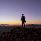
Notch Peak is located in Utah's west desert and is the 2nd Highest pure vertical drop in the U.S., at 2,200ft, behind El Capitan at 2,950. It is located in one of Utah's most remote areas, and provides truly isolated camping.
To access the trailhead you need a full size SUV or off-road vehicle. From the trailhead this hike is 3.5 miles each way, and follows the bottom of Sawtooth Canyon for most of it's duration. The Notch Peak trailhead is well established and starts along a wide gravel path into the first canyon. After about 5-7 minutes of walking you will encounter a major junction marked by a rock cairn, you will fork to the left at this junction and enter Sawtooth Canyon. The trail follows the bottom of Sawtooth canyon for about 3 miles up to a saddle. The trail is for the most part well established and marked by rock cairns, but if you loose it, just continue up the canyon to the saddle. The hike is intermediate in difficulty, there are several rock scrambles and small (5-7ft) climbs up dried up waterfalls. If you are not capable of these climbs, you can hike up gentle slopes out of the canyon and around them, just be sure to stay with the canyon, and re-enter is before you lose it. After about 2 miles, you will reach another junction in the canyon, again marked by rock cairns, again keep left and follow it up to the saddle to your left. From that saddle, hike to your left (south), up the gentle slopes to the true peak which is also marked by a rock cairn, and a USGS marker.
Download Outbound mobile app
Find adventures and camping on the go, share photos, use GPX tracks, and download maps for offline use.
Get the appFeatures
Notch Peak Trail Reviews
Great hike, fairly easy to follow, and climbing to the top from the saddle is worth the slog. I’d recommend pants as the trail was a bit overgrown and there’s plenty of brush to squeeze through. Most of the trail is walking up a moderate wash but there's a bit of light scrambling in the middle, after passing a BIG twisted pine that's broken off (and full of rocks) you'll want to bare left and stay in the wash/gulley. The last bit is more open but well cairned. If you hike to the peak (to the left as you approach the edge), it’s a shorter and easier to follow climb than it appears. The road to the trailhead was passable in a 2WD vehicle but a little clearance helps for the rocks/ruts on the dirt road.
5.0

The trail is really moderate until the final push to the saddle and then again to the summit. I went with my brother, sister-in-law, their dog, and their one-year old baby (carried in a backpack, of course). So, clearly, it is not a really strenuous hike. It was really desolate, but the view from the top is really cool. Not only can you see the lake bed of Lake Sevier, and nearby Ibex, but you can also see many snow-capped mountain ranges in every direction. Looking over the 2,000' ft drop was also a rather crazy experience. Highly recommend doing this hike! You can also camp there and see the coolest night skies in a really isolated part of Utah.
5.0
Leave No Trace
Always practice Leave No Trace ethics on your adventures and follow local regulations. Please explore responsibly!
Nearby

Bouldering at Ibex

Photograph the Highway 50 Shoe Tree

Gandy Warm Springs

Lehman Cave

Meadow Lava Tubes

Lexington Arch
Discover
Community
Mobile Apps

© 2026 The Outbound Collective - Terms of Use - Privacy Policy