
A short drive off the main road to a parking area. Neat to see how rugged the landscape is here compared to the smooth salt flats of Badwater only a few miles up the valley. It’s a short stop, there’s no real trails and it’s unlikely you’ll want to venture very far from the parking area due to how difficult it is to walk on.
4.0
Easy trail and a good introduction to the Redwoods. I thought Stout Grove was a bit better but any chance to take a peaceful stroll through these giants is worthwhile. If you’re looking for an even more serene walk with fewer visitors I’d suggest the James Irvine trail out of Prairie Creek, either as an out and back or make a long loop via Miner’s Ridge.
4.0
Great path between Incline and Sand Harbor for dog walking, jogging, and biking. The parking at Tunnel Creek fills up quickly but later in the day there are usually spots opening up. Bike or jog to Sand Harbor, take a swim, and return to Incline for a nice out and back. Other than the initial climb headed out of Incline the trail is fairly flat.
5.0
Very pretty hike through a rugged canyon. It does require navigating some drops and choosing the best path for your abilities. Keep an eye out for cairns and be prepared for some scrambling. Bring plenty of water, wear sunscreen or a sun cover, and maybe take a bathing suit if you’re brave enough to swim in the cool, clear Colorado (the water is cold because it’s coming from the bottom of the Glen Canyon Dam).
5.0
Beautiful and serene walk through the Redwoods, I only encountered a few other people toward the end of my hike. I thought the James Irvine trail was more scenic than Miner’s Ridge so if you’re not doing the loop I’d stay on James Irvine and just do an out and back. Lots of old growth Redwoods and plenty of unbelievably large tree trunks to marvel at. There’s also no sight or sound of civilization so you really feel like you’re “lost” in a coastal Redwood forest.
4.0
This is definitely the easier of the two bristlecone groves in the White Mountains to reach. The road is narrow and winding once you leave 168 out of Big Pine, your car will be short of air just like your lungs once you start walking the Methuselah Loop. The grove is at 10K feet so expect some altitude effects and take it easy, the trail is fairly easy but you'll want to enjoy your visit among these ancient trees.
5.0
We walked this trail while we waited for some misty/foggy conditions to clear. There are some steam vents with fences around them right at the parking lot, then a few more pits along the trail where steam permeates the ground. The Sulphur Banks stretch is mostly on a boardwalk, similar to Yellowstone, with plenty of signage to explain the formation of the area. We crossed over the road near the visitor center and returned via the Crater Rim Trail which has some steep drops and more steam rising from the bluffs below. Easy walking trail, very flat, and the crowds didn’t seem to venture very far from the first lookout point.
4.0
This is one of my favorite drives in the country, so much beauty along one road. The soaring peaks of the Sierra drop right off beside the valley and there's adventure around every corner. You probably won't end up here on accident but if it's a slightly longer option to get between A and B, definitely take it.
5.0
Nice parking area with a bathroom right on the sharp bend in the road, you’ll cross the road to drop in to the trail. The trail is a bit of sandy climb as you work your way back into the canyon, steeper at the start, with a few hills scattered in later, but the final portion is much flatter. The towering walls are a nice distraction and you can gauge your completion based on how much they’re closing in. A nice hike for scenery and distance in the Kolob portion of Zion, would be fun for kids who’ve got some hiking stamina (due to the sand).
4.0
I thought for sure it wouldn’t take around 2 hours to drive from Ubehebe Crater to the Racetrack but it really does. The road conditions probably vary based on maintenance but it was washboard gravel and lots of corners so maintaining speed was difficult. It’s a grind but the Racetrack is one of the most unusual and unique places in DVNP, definitely glad I made the trip (I was in a Chevy van). Depending on your comfort with rough roads and your vehicle choice, plan on the better part of a day for this round trip.
3.0
Short hike to an arch and then a couple hundred feet past that is a little cave-like alcove which feels sort of like a tube due to the collapsed material piled up in the center. The trail is fairly steep to drop down from the road, then it flattens out. This is a quick stopping point, we combined it with Cedar Wash Arch, the Dinosaur Tracks, and the Devils Garden for a bunch of short stops to break up an afternoon of exploring the trails/roads in GSENM.
4.0
Neat rock formations, similar to checkerboard mesa in Zion or the Vermilion Cliffs of the Paria. The drive to get there is part of the adventure with drop-offs and rough spots. The first part of the hike is basically down a dirt road but if you’re there in the right season (early spring, May-ish) it’s got blooming cacti among the juniper and pinyon pines. Once you reach the edge it opens up to some really nice views and you can sort of choose your own adventure among the candy cliffs, look for the cairns to get back “on track”. It can be a little difficult to navigate back to the main trail so I’d take some mental images or you’ll be searching the sandy areas for reassuring footprints. This is a pretty and unique adventure away from the main Utah attractions.
4.0
Short hike through some lush forest and then into a lava tube. Great hike for kids or those not able to hike some of the longer trails. The lava tube has some built-in lighting so headlamps aren’t necessary but some may prefer to wear them. There’s not a lot of parking along the road for it but you can park at the Kilauea Iki Overlook (if that’s not also full) and walk along the Crater Rim Trail, it adds a ¼ mile or less but you get some great vistas along the way.
4.0
One of the more popular and peculiar spots in DVNP. Neat to see the color variation between neighboring mounds and there’s plenty of trails to weave in amongst them if you’re looking for different vantage points. Unfortunately a lot of photos way over saturate Artist’s Palette so have reasonable expectations. Definitely a must-see while visiting the park, especially for those who may not be able to hike more strenuous trails.
5.0
Nice trail just off Eastlake Road, there's parking for a few cars right at the trailhead if you don't want to park at the State Park. Trail had markers at the necessary junctions and also had some signage for plants and animals, it was a nice touch! Would be a good path for trail running as it's expandable if you want more mileage.
4.0
This is a nice gravel trail through the sagebrush. Not much to it but it makes for a decent option that's not street or sidewalk. Would be nice for sunrise/sunset or a path for walking a dog on a nice day. And it has surprisingly good views of the surrounding area.
3.0
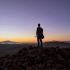
This is one of those hikes where most of the time you have your head down and you focus on just maintaining a slow and steady pace. I did this because Lassen Peak seemed crowded and I wanted a different vantage point, both of which it offers. The bit of the hike on the side of the mountain, once you're through most of the trees, is a slog up a pretty steady grade but it's worth the climb. I met two awesome people from Chico, we watched the sunset, the moonrise, and then we ended up "yogging" down together which made for a fast return to our cars. Not a "fun" hike but definitely one I would recommend if you don't mind a challenge.
4.0
I started at the Bumpass Hell parking area near Lake Helen and hiked through Bumpass and continued on to Cold Boiling Lake. The trail was easy to follow, there's a bit of a climb out of Bumpass and then it's mostly side-hill until you descend to Cold Boiling Lake. The morning I was there it was perfectly calm and nobody else was around, very serene. I ended up hiking out to the Kings Creek picnic area and walking back along the road until two Franks in a pickup truck gave me a ride back to my van (thanks again guys!!). Although it worked out for me that day, it probably makes more sense to do the hikes separately unless you can arrange transportation between the trailheads.
4.0
I hiked this with a friend in December, the trail was snow covered but due to the amount of foot traffic (and dry conditions) it was easy to follow and didn't require anything other than shoes. We made a loop by taking the TRT (Tahoe rim trail) out and coming back on Castle Rock trail. It's fairly flat, the elevation gain is gradual, and there is some scrambling at the end if you want to climb atop Castle Rock (you can see the lake without the climb). Only bummer on the day was hiking out right before an amazing sunset...always stay for sunset.
5.0
Fairly easy hike but the path is narrow and traverses along a slope so it's not very flat. There's no shade except for the very end so not the best for hot, sunny days. Great hike in fall/winter if it's free of snow or in the spring when the waterfall volume is highest.
3.0
Each lookout makes you feel closer and more in awe of the mountain which entices you to keep going. If you’re planning to do this AND Fremont Fire Lookout I’d suggest trying to allot enough time to do them both in the same trip since the first half of each trail is the same. Sourdough trail offers good views over the ridge, I don’t know about the Sunrise trail but that’s an option if you want to mix it up.
4.0
Great views for 270 degrees, from distant Glacier Peak to the looming Rainier and countless peaks and ridges of the Cascades. If you’re planning to do this AND Burroughs I’d suggest trying to allot enough time to do them both in the same trip since the first half of each trail is the same. Sourdough trail offers good views over the ridge, I don’t know about the Sunrise trail but that’s an option if you want to mix it up.
4.0
This trail is very popular for a reason. Thankfully at least some of the traffic ends at the insta-log (don't be surprised to see a decent line). I swam in the upper lake and it was cold and refreshing, definitely recommended for those brave enough to try!
5.0
Great hike, fairly easy to follow, and climbing to the top from the saddle is worth the slog. I’d recommend pants as the trail was a bit overgrown and there’s plenty of brush to squeeze through. Most of the trail is walking up a moderate wash but there's a bit of light scrambling in the middle, after passing a BIG twisted pine that's broken off (and full of rocks) you'll want to bare left and stay in the wash/gulley. The last bit is more open but well cairned. If you hike to the peak (to the left as you approach the edge), it’s a shorter and easier to follow climb than it appears. The road to the trailhead was passable in a 2WD vehicle but a little clearance helps for the rocks/ruts on the dirt road.
5.0
Discover
Community
Mobile Apps

© 2026 The Outbound Collective - Terms of Use - Privacy Policy