
Warren Behymer
Sharing my weekend adventures in the mountains from Washington State. Hiking, mountain running, camping and backpacking.

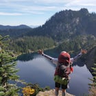
Camp and Trail Run from Rainbow Lake
North Bend, WashingtonI backpacked to and setup basecamp at Rainbow Lake and then I ran over to Island Lake. After enjoying the peace and quite I ran up to the top of Bandera Mountain and enjoyed the views. Then, I ran back to basecamp and spent the night. The following morning I ran up to the top of Mount Defiance and had an amazing view of Mount Rainier at 8:30 am with no one around.Once I was ready, I ran back t...

Tuscohatchie Lake via Pratt Lake Trail
North Bend, Washington
5.0
13.13 mi
/ 3330 ft gain
This is a beginner to intermediate hike, at the first mile the trail has it first break where you can go up to the Lookout. If you continue going straight, you'll find waterfalls and lakes on the trail. 2.5 Miles in on the trail is another turn to Ollalie and Talapus Lake. Continue onto the 4-mile maker and you will find another turn one to Island Lake and the other to Pratt Lake.
Pratt Lake...

Run to Lower Wildcat Lake
Leavenworth, Washington
1.0
Friday after work I headed out to Snow Lake Trail and found my perfect camping spot. There is a sign that says no Camping but I broke the rule since I got the ok from the Forrest Department of Agriculture. Spent the night at Snow Lake and then Saturday I ran over to Gem Lake and notice no one there. Ran up to Lower Wildcat Lake and went up the summit there. An Amazing view of the area but be...

Alaska Lake via Gold Creek Pond Trail
Snoqualmie Pass, Washington
11.62 mi
/ 2303 ft gain
Driving Directions:
From Seattle drive east on I-90 to exit 54 (signed "Hyak"). Turn left (north) under the freeway and right on the frontage road marked "Gold Creek." After about 0.5 mile turn left (north) on Gold Creek Road (Forest Road 4832), and in another 0.5 mile reach a junction. To the left is the Gold Creek Pond area--parking is available there if the road ahead is gated. If the gate...

Lillian Lake
Snoqualmie Pass, Washington
5.0
8.36 mi
/ 2969 ft gain
We backpacked our way to Lillian Lake and set up camp. There is a trail that lead around the lake and a trail that leads up to Rampart Lakes and Rachael Lake as well. We found a few more camps spots on Lillian Lake, then we noticed that only ONE other camp spot was being used.
If you want peace and quiet I highly suggest this. After lunch we spent the rest of the afternoon fishing for lake tr...

The Enchantments Mountain Run
Leavenworth, Washington
5.0
18 mi
/ 6000 ft gain
At the Snow Lake Trail, you start at a elevation of 1400 feet and run up to Nada Lake 5000 feet at 5.6 miles. From here, you make your way to Lower and Upper Snow Lake, 2.2 miles. There are a lot of campsites in this area, but you have to apply to stay the night at these lakes.
You will need to follow the trail and a bunch of cairns to get from Upper Snow Lake to the Enchantment Lakes. Once I...

Kaleetan Lake via Denny Creek Trail
North Bend, Washington
19.31 mi
/ 6273 ft gain
If you want to visit multiple lakes, get a view of or tackle a peak at Kaleetan, Chair, and Bryant, campgrounds for overnight or weekend adventures, fish in the lakes, explore off the trail and natural waterslides and picnic area waterfalls, this is for you. Denny Creek Trail offers it all!
After the first mile on the trail, you will run into the Natural Waterslide and rocks that you can have ...

Rattlesnake Mountain Traverse Run
Snoqualmie, Washington
21.1 mi
To Snoqualmie Point Park, from Seattle take I-90 east to Exit 27. At the end of the off-ramp, go right and follow the road to the end. Go through the gate on the right to enter the trail head To Rattlesnake Lake: From take I-90 to Exit 32. Go south on 436th Ave. SE, turning into Cedar Falls Rd. SE - follow this main road 3.1 miles to the parking area for Rattlesnake Lake. To reach the trail ...

Summerland Trail
Ashford, Washington
5.0
8.62 mi
/ 2359 ft gain
The Summerland trail is by far the easiest trail that I ever experienced. The trail is well maintained and for the first 3 miles you are surrounded by trees and the sound of waterfalls and rivers, and it's green everywhere. The last 1.3 miles, you encounter switchbacks and you can get some views of the peak of Mount Rainier on the way up.
There's plenty of wildlife in close proximity to the ...

Lake Ann via Lake Ingalls Trailhead
Leavenworth, Washington
8.61 mi
/ 2513 ft gain
Both trails start at the Esmeralda Trailhead, Trail Number 1394. Lake Ann has a handful of folks that you will run into, whereas Lake Ingalls is a well-traveled trail. Both offer camping spots along the trail, and Lake Ann has spots where you can camp by the lake. NO CAMPING ALLOWED at Lake Ingalls, however.
The first .3 miles is a rocky and loose dirt run uphill. When you see a post on your r...

Winter Camping in Leavenworth
Leavenworth, WashingtonIt's an easy day hike to the Ridge of only 2.5 miles. On the ridge you can relax and enjoy the view of the surrounding mountains and a view of Leavenworth. I went into the Rangers office to ask for a good spot to take night time photos and this is one of the areas they suggested. Make sure you get approval for over night camping at this trail beforehand. It's best to check at the Ranger's offic...

Hike Alta Mountain
Snoqualmie Pass, Washington
4.0
12 mi
/ 3300 ft gain
Start off at Trail #1313 to Rachel Lake. The first 2.5 miles is a flat, slow uphill hike till you get to a river crossing. From there, the next 1.3 miles will be a 1,000 foot elevation gain to Rachel Lake. Once you arrive, this is a good spot to rest, eat some snacks, and replenish your water supply.To your right, you will pass two signs, pointing to the toilet and a trail. Follow the trail up ...

Hike to Rainier NP's Ranger Falls
Ashford, Washington
4.5
7 mi
When heading to the adventure, stopped at the ranger station in Carbon to get your day pass ($5.00) and then continue on to the trailhead. Park on the road next to the Carbon river around. Start the hike down an old paved road that eventually leads through some trails and then to a gravel road. This was about 2.5 miles or so to get to the trailhead for the Ranger Falls.From the trailhead, it's ...

Winter Backpack to Blanca Lake
Gold Bar, Washington
5.0
7.5 mi
/ 3300 ft gain
Since Blanca Lake is a very popular place for folks to explore and with the nice and sunny weekend. I drove out Friday night and slept in my Jeep. Got up at 7:30am when folks first started arriving to the trail head.A couple of things to keep in mind before you start this hike. The 7.5 miles round trip can be deceiving. You are gaining 3300 ft. This quite a strenuous hike, especially if you a...

Trail Run to Robin Lakes
Ronald, Washington
17 mi
/ 4100 ft gain
Starting Elevation: 3400 Feet Ending Elevation: 6178 Feet Round Trip Run: 17 Miles Total Elevation Gained for the Day: 4100 FeetIt's best to drive to the trailhead the night before and camp out (I slept in my Jeep to get an early start on the next morning). The parking lots are jammed full on the weekends and cars can be parked on the side of the road about .5 mile away from the trailhead.Start...

Rampart Lakes
Snoqualmie Pass, Washington
5.0
9.11 mi
/ 2556 ft gain
The Trail:
With very little elevation gain, the first three miles of the trail are the easiest; the next mile up to Rachel Lake is great work out. After reaching Rachael Lake, look for the sign that says "trail" to find your way to Rampart Lakes. While there are many side trails that turn out to be dead ends, they'll lead you to amazing views.
When you get to the ridge, you’ll see a trail o...
Discover
Community
Mobile Apps

© 2026 The Outbound Collective - Terms of Use - Privacy Policy