Lake Toxaway, North Carolina
Looking for the best camping in Lake Toxaway? We've got you covered with the top trails, trips, hiking, backpacking, camping and more around Lake Toxaway. The detailed guides, photos, and reviews are all submitted by the Outbound community.
Top Camping Spots in and near Lake Toxaway
-
Sunset, South Carolina
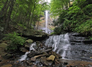
Virginia Hawkins Falls (Double Falls)
4.02.6 mi / 456 ft gainA moderate to advanced 2.6 mile hike has many stairs and a lot of ascents and descents along the way. The hike may not be the easiest but the payoff is worth it. The trail is easily marked so no need to worry about getting lost.Read more -
Salem, South Carolina
Camp on Lake Jocassee
4.7To avoid the regret of cutting your trip too short, go ahead and book a campsite. Come as a walk-in or reserve your site. Either way, you will have to check in at the Park Office. Upon check-in, you will receive your map and general information. Check-in time for camping is 2PM. The only publi...Read more -
Canton, North Carolina
Sam Knob and Flat Laurel Creek Loop
4.93.84 mi / 807 ft gainThis is one of my favorite quick "getaway" loops in the Pisgah Ranger District. Turn onto Black Balsam Knob Road (Mile Marker 420 on the Blue Ridge Parkway) go until you reach a dead end and park at the parking lot. You'll see the Sam Knob trail to the right of the public bathrooms. From there, i...Read more -
Canton, North Carolina
Graveyard Fields-Black Balsam Knob Circuit
4.49.83 mi / 1522 ft gainWhen the weather is in your favor, these treeless mountain tops will have your jaw on the floor with layers upon layers of Blue Ridge Mountains. This hike can be done in one day, but with panoramic views at multiple points, you'll want to take your time along this link of trails. This ~10-mile l...Read more -
Brevard, North Carolina
Looking Glass Rock
4.65.43 mi / 1572 ft gainThis is a really nice, moderately difficult hike along a cascading creek, up switchbacks, and through wildflower fields. A couple miles in, you'll reach a helipad that is used for rescuing injured rock climbers - Looking Glass Rock is a popular destination for world class climbing. There is a sma...Read more -
Canton, North Carolina
Skinny Dip Falls
4.81.03 mi / 148 ft gainPark at the Looking Glass Rock Overlook. After enjoying the view of Looking Glass Rock, gear up and head to the right side of the parking area (right side if your back is to the overlook). On the opposite side of the road you'll see a mile marker and a little trail to the left of the marker. Foll...Read more -
Pickens, South Carolina
Backpack the Foothills Trail through the Southeastern Appalachian Mountains
5.076.2 mi / 11036 ft gainStarting at Table Rock State Park (South Carolina) and working your 76.2 miles way towards Oconee State Park (South Carolina) is the most popular route, with a few spur trails that lead to places like Raven Cliff Falls in Cesar's Head State Park. The trail gains ~11,036 feet in elevation with ano...Read more -
Pickens, South Carolina
Summit Sassafras Mountain
5.017.2 mi / 5041 ft gainPinnacle Trail begins by the Nature Center in Table Rock State Park. Keep left at the first three splits in the trail. You will make some creek crossings, gain elevation through the forest, and pass by Mills Creek Falls (25 ft). At Bald Rock Overlook, you can catch some nice views of Table Rock M...Read more -
Mountain Rest, South Carolina
Hike to Big Bend Falls
5.06.5 miThe hike to Big Bend Falls begins on the Chattooga River Trail at the Burrell's Ford Campground. To get here you take Burrell's Ford Road off of SC 107. There will be a good sized gravel parking area off to the left about 3 miles down Burrell's Ford Road. When you park the car you can walk down t...Read more -
Brevard, North Carolina
Art Loeb Trail
4.830.07 mi / 7467 ft gainStart at The Davidson River Campground just outside of Brevard, NC (276 Pisgah Ranger District). Have a shuttle car or a friend waiting at the Daniel Boone Boy Scout camp for the finish line. Hop on the 30.1 mile long Art Loeb Trail at the trailhead in the Davidson River Campground. Pull into th...Read more -
Brevard, North Carolina
Camp at Davidson River Campground in the Pisgah National Forest
4.5Pisgah National Forest, in my opinion, is one of the best national forests in the United States. Being just a short drive from Great Smokey Mountain National Park it has all the feel of being in the smokies with more to explore. Pisgah has anything you could want to see or do from tens of water...Read more -
Canton, North Carolina
Shining Rock via Shining Creek Trail
4.38.69 mi / 2569 ft gainThere are several ways to access the Shining Rock Wilderness Area, but go for the main trail head off of Hwy 276. The trail is split by the Pigeon River, providing a seemingly infinite combinations of trails and routes, keeping in mind that this area intersects often with the well known Art Lobe ...Read more -
Canton, North Carolina
Hike Big East Fork Shining Rock Loop
4.014 miWe began this trip by camping overnight in Graveyard Fields. Those camp sites are .5 miles from the car, so we kept our food there over night. Bear activity has increased, so it's strongly advised to bring a bear canister and be wise about food storage. We woke up early the next morning made bre...Read more -
Greenville County, South Carolina
Hike to Rainbow Falls and Pretty Place
5.05.96 mi / 1844 ft gainJones Gap State Park in the Upstate of South Carolina is one of the most beautiful parks in the state offering a good range of moderate and challenging hiking and backpacking trails through the Mountain Bridge Wilderness Area. Jones Gap also provides superb primitive camping sites along the rocky...Read more -
Canton, North Carolina
Camp at Mt. Pisgah
5.0The Mt. Pisgah campground is nestled right off of the Blue Ridge Parkway near Canton, NC. Since it is at an elevation of 4,980 feet the campground is a perfect destination to beat the heat and humidity that the region can be known for in the summer months. Reservations and information can be fo...Read more -
Dillard, Georgia
Hike to Rabun Bald
5.03 mi / 4696 ft gainStarting at the trailhead you begin by following the yellow blazes. The trail isn't well marked so keep an eye out for the blazes you see. The trailhead starts at the dead end of Kelsey Mountain Trail. The path immediately starts to incline and doesn't stop. A few minutes in you will come to a fo...Read more


