Arroyo Seco, New Mexico
Looking for the best hiking in Arroyo Seco? We've got you covered with the top trails, trips, hiking, backpacking, camping and more around Arroyo Seco. The detailed guides, photos, and reviews are all submitted by the Outbound community.
Top Hiking Spots in and near Arroyo Seco
-
El Prado, New Mexico
Manby Hot Springs
2.31.5 mi / 300 ft gainNOTE: The Hot Springs are on private property and are no longer accessible to the public. The Basics: Hot springs abound in the Taos area. From the all-inclusive (and expensive) Ojo Caliente Mineral Springs Resort to free, primitive hot springs like this one or neighboring Black Rock Hot Spr...Read more -
Taos Ski Valley, New Mexico
Climb Mount Wheeler
4.76.2 mi / 3083 ft gainMount Wheeler is the highest peak in New Mexico at 13,161 feet and is considered the 8th highest state peak. The hike begins just over 10,000 feet near the Bavarian Restaurant. Drive past the Taos Ski Resort and follow the signs for the restaurant until the road ends. The 6.2 mile trek begins a...Read more -
Taos Ski Valley, New Mexico
Hike to Williams Lake and Wheeler Peak
5.0This hike is conveniently located at Taos Ski Valley and offers two primary options: a fun 4-mile round trip hike to beautiful Williams Lake, or a 7-mile round trip hike all the way to the Wheeler Peak. You can’t go wrong with either option, but if you’re up for it, bagging Wheeler Peak is defini...Read more -
5 Reyna Road, New Mexico
Relax in Black Rock Hot Springs
0.3 mi / 68 ft gainAt the last switchback on Country Road B-007, is where the trailhead is located. if you've gone to the lowest point possible within the canyon, right next to the river, you have gone too far and need to turn around to the last switchback. it is an easy .3 Mile trail with a 68 foot elevation drop/...Read more -
El Prado, New Mexico
Hike the Rio Grande Gorge Bridge Trail
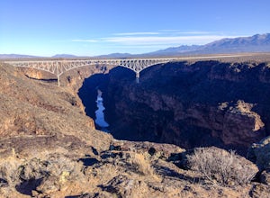
6 miDrive 12 miles west of Taos, New Mexico on US Hwy 64, and you'll drive directly onto the Rio Grande Gorge Bridge that spans 1,280 feet. There's a rest area to the west of the bridge with a parking lot, sitting area, and if you're lucky like we were, a converted sky blue bus selling homemade desse...Read more -
U.S. Highway 64, New Mexico
Devisadero Peak
5.48 mi / 1375 ft gainThe Basics: 8,304 foot Devisadero Peak, which literally translates to "lookout," does not actually provide a great view from its treed summit. However, this lollipop loop hike has many vantage points over the Taos Valley as it snakes up and around this foothill mountain. To get to the trailhea...Read more -
Red River, New Mexico
Hike Colombine Trail
8.5 mi / 1935 ft gainThis moderate trail is accessed from the Columbine campground on Highway 38. It will be on your right side when traveling east from Questa. Drive to the back end of the campground, where there are several spaces for parking. The moderate version of this hike will travel about 4 miles south into t...Read more -
Questa, New Mexico
Camp at Rio Grande del Norte National Monument
4.32.4 mi / 800 ft gainCreated in 2013 from partly existing public lands, The Rio Grande del Norte National Monument encompasses a large amount of land along the Rio Grande River from the Colorado border to south of Taos. Far from any major city, you'll likely enjoy trails to yourself in the morning and few other visit...Read more -
Red River, New Mexico
Hike the Red River Nature Trail
2 miThe Red River Nature Trail starts right in town next to the Platinum Lift off Pioneer Road. The trail travels 2 miles to Goose Lake Road. The hike itself can be taken as a two or four mile hike, depending on weather you access it point to point or out and back. We started the trail behind the vis...Read more -
Red River, New Mexico
No Name Point
Not even a mile down Bitter Creek Rd, there’s a right-hand turn that takes you next to this spectacular rock outcropping. There's a little dirt parking area when you come down and around the turn that sits right next to Bitter Creek itself. It’d be a swell place hang out, play around on the roc...Read more -
Red River, New Mexico
Explore Mallette Park & Canyon
We stumbled upon this little gem as we were driving through town. This park is nestled right at the base of Mallette Canyon and has several features that becken a winter visit. Along the west side of the canyon, over the small green bridge in the park you will find yourself following along a quar...Read more -
Red River, New Mexico
Enchanted Forest Snowplay Area
Just above the town of Red River up Bobcat Pass is the Enchanted Forest. As you approach the top of the pass you’ll see signs that point you toward the forest into what looks like a neighborhood. Trust the signs and make the turn. Follow the main road up through the neighborhood and take your sec...Read more -
La Senda de Medio Trailhead, New Mexico
Hike La Senda de Medio Trail
5 miIf you find yourself in Taos for the weekend, the La Senda del Medio trail is a perfect hike to add to your adventure. About 20 minutes south of town and located in Rio Grande del Norte National Monument, this trail follows the Rio Grande for 2.5 miles and connects 5 different campgrounds. The tr...Read more -
Colfax County, New Mexico
Hike to Clear Creek in Cimarron Canyon State Park
4.02.5 mi / 1000 ft gainHead North from Eagle Nest towards Cimarron, and about 7 miles (or less) on your right hand, you will find two big signs with a parking area on both sides of the road. If you park on the right side, walk on the inside of the guardrail until you find the trail head sign. If you parked on the left ...Read more -
Chamisal, New Mexico
Hike to the Trampas Lakes in Carson National Forest
4.911 mi / 2400 ft gainThis hike is worth its weight in gold. By far one of the most beautiful places in all of New Mexico. Located in the Carson National Forest, the options for camping are limitless. Did I mention this is ranked one of New Mexico's best hikes yet it rarely gets done. The potential for solitude is ver...Read more

