Elwood, Illinois
Top Spots in and near Elwood
-
Chicago, Illinois
Lakeshore Path: North Ave Beach to Navy Pier
1.84 mi / 72 ft gainLakeshore Path: North Ave Beach to Navy Pier is a point-to-point trail that takes you past scenic surroundings located near Chicago, Illinois.Read more -
Des Plaines, Illinois
Watch the Sunset at Axehead Lake
In a large city, it's nice to be able to find pockets of nature oasis amidst the chaos. It's great to come here with a journal or sketchbook and pass the time while watching the sunset. Fishing is available at this lake and there is a forest preserve that has a couple small trails.Read more -
Chicago, Illinois
Run Chicago’s Lakefront Trail
5.06.7 miChicago – the third largest city in the US and home to the deep dish pizza – doesn’t exactly scream “outdoorsy.” In reality, there is much more to Chicago than skyscrapers; there are dozens of parks, outdoor music venues, and the city is right on Lake Michigan, making it very easy on the eyes. Be...Read more -
Oglesby, Illinois
Hike to Starved Rock's La Salle Canyon
4.34.4 mi / 370 ft gainThis out-and-back trail is one of the parks longest trails. Starting from the visitors center it is 2.2 mile hike one way and 4.4 miles if you go out and back. The trail is very much worth the long trek. You enjoy the views and fresh air of the Illinois river. You will also walk past the Illinois...Read more -
Oglesby, Illinois
Hike to Wildcat Canyon at Starved Rock SP
4.52 miIf you happen to find yourself in the Chicagoland area be sure to check out the Wildcat Canyon hike at Starved Rock State Park. This is a 2 mile out and back hike from the visitor's center that leads to the largest waterfall in the park. There are two viewpoints from the top of the canyon or yo...Read more -
Oglesby, Illinois
Hike Starved Rock's French Canyon
4.50.4 miStarting from the visitors center or the parks restaurant, depending on where you parked. If you were forced to park by the restaurant because of a busy day, you will start the trail head with a map of the park. You will follow the tallest stairs of the park down to the visitors center where the ...Read more -
Oglesby, Illinois
Hike Ottawa Canyon at Starved Rock State Park
5.03.9 miThis canyon is not as popular as some of the others in this park but it is my favorite by far. You can either hike the full 3.9 miles from the visitor center or you can jump in your car and head over to one of the parking lots on the east side for a shorter hike. Either way you will not be disap...Read more -
Oglesby, Illinois
Hike to St. Louis Canyon at Starved Rock State Park
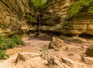
5.03 miStarved Rock has some very interesting rock formations you can explore. The valley was formed by a series of floods as glacial melt waters broke through moraines, sending torrents of flood water surging across the land that eventually eroded the sandstone and sedimentary rock. If you arrive in ...Read more -
Oglesby, Illinois
Red River Loop
2.57 mi / 266 ft gainThe Red River Loop in Matthiessen State Park River Area runs alongside the Vermillion River and is typically used by hikers, walkers, and those wishing to see unique birds. The Red River Trail is open for use year-round. The trail winds through beautiful canyons, streams, prairies, and forests in...Read more -
Oglesby, Illinois
Hike the Lower Dells at Matthiessen State Park
4.83.5 mi / 250 ft gainStarting off right from the parking lot at Matthiessen State Park, follow the trail markers through the forest, across beautiful bridges, and find your way to one of the many stunning waterfalls. Depending on when you go, the water level will vary greatly. During the summer months the water level...Read more -
Oglesby, Illinois
Hike the Upper Dells of Matthiessen State Park
4.32.2 mi / 627 ft gainFrom the start of the parking lot you will cross a picnic area to your left where you can have a bite to eat before or after your hike. The trailhead starts off with a couple flights of stair leading you down to the bridge. After taking in the spectacular views at the top of the waterfall you wil...Read more -
Oglesby, Illinois
Hike the Matthiessen State Park Loop
4.85.8 miWith 5 miles of trails, which alternate between cliffs, canyons, and bluffs, Matthiessen State Park has plenty to offer. This particular trail also includes three waterfalls, along the way. From the Dells Area parking lot, head down the steps next to the log fort replica. At the 4-way junction tu...Read more -
Gary, Indiana
Hike the Dune Succession Trail, Indiana Dunes National Lakeshore
4.51 mi / 150 ft gainThis hike provides a great opportunity to explore the variable landscape and terrain in Indiana Dunes National Park. From the parking lot head north on a paved walkway toward Lake Michigan's shoreline. Next, walk down the boardwalk to the beach. Once you reach the coast, you'll have amazing view...Read more


