Sanger, California
Top Spots in and near Sanger
-
Sequoia National Park, California
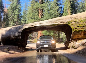
Drive through Tunnel Log
Tunnel log is a massive fallen sequoia across the middle of the road, which is a great photo opportunity for visitors of the national park. The mammoth tree fell over in 1937, but a year later, a car tunnel was carved in the middle of its trunk so vehicles could still pass through. Although the...Read more -
Sequoia National Park, California
Hike the Congress Trail
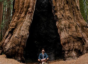
5.03.1 mi / 500 ft gainWhile the General Sherman Tree is the main attraction in this area, the Congress Trail allows you to get away from the majority of the crowd and explore the giant sequoias at your leisure. The vast majority of visitors only walk to and from the General Sherman Tree. The trail starts out from the ...Read more -
Lakeshore, California
Hike to George Lake
9.2 mi / 1050 ft gainThe hike to George Lake starts out about 4 miles after you turn off 168 onto Kaiser Pass Rd. You'll want to park at the parking lot right before Badger Flat Campground. The parking lot is easy to notice and it is located on the right hand side of the road, two pit toilets and bear lockers are loc...Read more -
Sequoia National Park, California
Camp at Buckeye Flat in Sequoia National Park
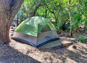
Entering Sequoia National Park at the Ash Mountain Entrance near the small city of Three Rivers, follow Highway 198 (Generals Highway) through the park until you see a sign for Buckeye Flat Campground off to the right. The campground sign is immediately after you see signs for Hospital Rock. Foll...Read more -
Sequoia National Park, California
Backpack the High Sierra Trail
5.071 miThe High Sierra Trail begins at Crescent Meadow in Sequoia National Park, on the West side of the Sierra Nevada range, and ends at Whitney Portal on the East, traversing the highest and most beautiful part of the Sierras. From deep river canyons to high alpine peaks, lakes, and meadows, this hike...Read more -
Sequoia National Park, California
Hike Crescent Meadow
4.51.6 miCrescent Meadow is a collection of loops in the Giant Forest in Sequoia National Park. The trailhead is located just past the tunnel log east of General's Highway 198. The main loop is 1.6mi total. However you can take any of the loops to the General Sherman tree 3mi, Tharp's Log trail 0.5mi, or ...Read more -
Sequoia National Park, California
Hike to Emerald Lake, Sequoia National Park
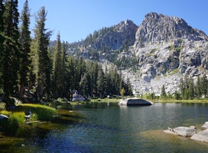
4.510.4 mi / 2200 ft gainBegin this hike at the Alta Peak Trailhead in the Sequoia National Park. The trail initially takes you east-southeast through a loosely forested area that is stark and arid. Around 1.5 miles in you'll cross a small creek, but this creek may dry up in the late spring/summer. Shortly after the cree...Read more -
Sequoia National Park, California
Hike to Pear Lake via the Lakes Trail
5.012.4 mi / 2300 ft gainThe Lakes Trail to Pear Lake can be done as either an overnight stay or a day hike. For overnight, you'll need to get a permit but there are beautiful camping spots available at both Emerald Lake and Pear Lake. As a day hike, plan to spend all day since you'll undoubtedly pause at each lake for...Read more -
Sequoia National Park, California
Backpack to Big Bird Lake & Moose Lake
30 mi / 8000 ft gainThis trip requires a wilderness permit. You can get one at the Lodgepole Visitor Center where you can also rent a bear canister or use the bathroom before heading out.Wolverton Trailhead -> Big Bird Lake (~12 miles)The start of the trail is on the left side of the parking lot and towards the m...Read more -
Sequoia National Park, California
Mount Silliman, Sequoia NP
5.011.24 mi / 4449 ft gainThere is available parking at the campgrounds at the Lodgepole Visitor Center. Lodgepole's elevation starts at 6720 ft. Twin Lakes Trailhead starts right at the base, which you will be following to get to Mount Silliman. Along Twin Lakes Trail are several campgrounds for your journey, you can go...Read more -
Bass Lake, California
Climb and Camp at Shuteye Ridge
5.0The Journey to your final destination can get a little tricky once you get on the dirt roads. From the Bay Area it will take you about 3 hours to get into Oakhurst, then another hour to get to the Wilderness Area simply because of the windy and not maintained roads. On that note I would suggest t...Read more -
Tulare County, California
Tokopah Falls
4.23.77 mi / 617 ft gainThis hike starts from the Lodgepole area of Sequoia National Park. Parking is easy at the easternmost end of the paved road prior to entering the campground. From the south side, the trail starts off by crossing the Marble Fork of the Kaweah River to the north side. It then loosely follows the r...Read more -
Lakeshore, California
Hike to White Bark VIsta
2.3 mi / 462 ft gainA short 1 mile hike in from Kaiser Pass will lead you to the top of a ridge line with incredible views toward the east. There are two pit toilets located at the top of Kaiser Pass. If you have a high clearance, 4x4/AWD vehicle you can probably drive to this location. (I made it up here in a stock...Read more -
Bass Lake, California
Camp at Greys Mountain Campground
/ 5293 ft gainFrom Greys Mountain Campground, Sierra National Forest is your oyster! Enjoy hiking, swimming, fishing, mountain biking, boating, paddle boarding, kayaking, canoeing, and more. Each site is equipped with a picnic table and a fire ring. The campground has vault toilets and (sometimes) potable wate...Read more -
Fresno County, California
Hike to Lookout Peak
12 miYou'll want an early start to this hike so consider camping in the park the night before. If you enter the park via CA-180 and follow it for a ways (passing Kings Canyon Visitor Center, Kings Canyon Lodge, and eventually the Cedar Grove Visitor Center) you'll come up to two campsites on the left-...Read more -
Oakhurst, California
Hike the Shadow of the Giants Trail
4.01.1 mi / 85 ft gainThe Shadow of the Giants National Recreation trail is an amazing 1.1 mile self-guided hike through the heart of Nelder Grove. Take Hwy 41 north from Fresno; continue thru Oakhurst to Sky Ranch Road (6S10 or Forest Road 10) travel approx. 5 miles to Nelder Grove, when you reach the camp area take ...Read more

