Loma Linda, California
The best Trails and Outdoor Activities in Loma Linda, California, include the popular Hulda Crooks Park. Known for its top-rated hiking trails, it offers scenic views of the San Bernardino Mountains. The 4.5-mile South Hills Preserve Trail is a must-visit for its unique rock formations and panoramic views of the Inland Empire. The trail is of moderate difficulty, making it an ideal outdoor adventure for most fitness levels. In addition, Loma Linda also boasts the Santa Ana River Trail, a flat, paved pathway perfect for cycling and running. For water-based activities, the nearby Lake Perris offers fishing and boating opportunities. These outdoor activities make Loma Linda an ideal spot for those seeking fun and adventure in California.
Top Spots in and near Loma Linda
-
Claremont, California
Stoddard Peak Trail
4.05.93 mi / 1129 ft gainOn the way to Mount Baldy and within the trail system of the San Gabriel mountain range is the Stoddard Peak Trail. The Stoddard Peak Trail, which is basically the old Barrett-Stoddard fire road, goes through the Stoddard Canyon into Stoddard Flat, and then eventually leads to Stoddard Peak. The ...Read more -
Mount Baldy, California
Summit Mt. Baldy
4.812.12 mi / 5958 ft gainLocated only an hour’s drive from Los Angeles is the top of highest mountain in LA County—at 10,064 feet. Bear Flat Trail (also called the Old Mt. Baldy Trail) offers some of the finest scenery and most rewarding views in the San Gabriel Mountains high country. With nearly 6000 ft of elevation g...Read more -
Claremont, California
Stoddard Canyon Falls (Baldy Slide Waterfall)
0.74 mi / 174 ft gainLocated near the Angeles National Forest, it's a short hike, approx. 0.75 miles roundtrip and just about anybody can go. To get there, input the intersection of Mt. Baldy Rd. and Barrett Stoddard Truck Trail into your GPS. This will bring you to a small dirt parking lot. The trailhead starts a...Read more -
Claremont, California
Claremont Wilderness Loop
4.85.03 mi / 1020 ft gainDrive to the top of Mills Ave in Claremont. There is a main parking area to the left and overflow parking a block south on the right. It costs $3 to park for 4hrs. As the name implies, the Wilderness Loop is a loop that connects to other trails in the Claremont Hills Wilderness. You can choose t...Read more -
Mount Baldy, California
Sunset Peak via South Trailhead
4.07.16 mi / 1493 ft gainIn order to get to the Sunset Peak Trailhead, utilize Google Maps to take you to the location provided. There is very little parking (only a small pull off along Glendora Ridge Road), but this trail is rarely traveled, so there should be enough space regardless of the time you decide to hike! Jus...Read more -
Big Bear, California
Holcomb Valley Campground
This campground is awesome! With great views, plenty of space and clean bathrooms it'll have you in for a treat! Whether it be a multiple day trip or just one night this campground is awesome. Read below for information if you are looking for a trip in the mountains! Cost: This campground is a ...Read more -
Silverado, California
Bedford Peak Trail
5.06.78 mi / 1972 ft gainThe Bedford Peak Trail in Silverado, California is a challenging hike that offers a variety of natural features. The trail spans 6.78 miles round trip and has an elevation gain of 1,972 feet. It is rated as difficult due to its steep inclines and rocky terrain. The trail begins in a dense oak w...Read more -
Big Bear, California
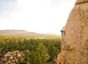
Rock Climb Holcomb Valley
5.0Most of the drive to Holcomb Valley is done on regular paved roads until about the last hour when you get above Big Bear Lake and you start your journey on dirt roads. The road is extremely bumpy and has lots of pot holes but there are generally quite a few cars up there that don't have 4 wheel d...Read more -
Big Bear, California
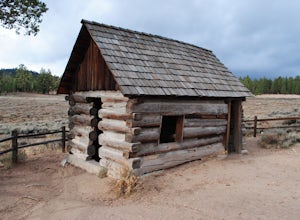
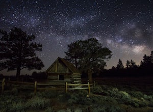
Explore Van Dusen Cabin
4.0This is a great day trip to spend in the mountains. from Highway 18 at the Big Bear Dam you turn left onto highway 38 around the north shore of Big Bear. Continue till you see the sign Van Dusen Rd and turn left. The paved road takes you through residential neighborhoods where the dirt road begin...Read more -
Cabazon, California
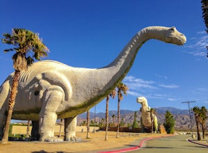
Check Out the Cabazon Dinosaurs
4.3For any fans of Pee-Wee’s Big Adventure or The Wizard, the Cabazon Dinosaurs are instantly recognizable. A roadside attraction off of Hwy 10 - 90 miles east of Los Angeles - the dinosaurs, heralded as the “World’s Biggest Dinosaurs", are a quick adventure.To get to the dinosaurs, you’ll travel on...Read more -
Lake Elsinore, California
Ride the San Juan Trail
4.511 mi / 3400 ft gainThe San Juan Trail is located off the Ortega Highway (Hwy 74) in Southern Orange County. It is done frequently as a long, 11 mile climb that is rewarded by an almost continuous descent of 3400ft. The out-and-back trail head is back Hot Spring Canyon Rd from the San Juan Fire Station. It can also ...Read more -
Corona, California
Hike to Santiago Peak via Holy Jim
5.015 mi / 4500 ft gainWhen you think of Orange County, you think of beaches, boardwalks, but what you may not know is that there are some great hikes in our very own backyard! My favorite is a fairly strenuous day hiking adventure that only the strong survive. Not to dissuade any interested parties, since this is a ...Read more -
Corona, California
Hike to Holy Jim Falls
3.02.9 mi / 570 ft gainTo start, directions on how to get to the trail there are two different ways, the most common , which I will explain, being through Rancho Santa Margarita you will head east on Santa Margarita Parkway, turn left at the dead end (into a parking lot for a shopping center) on Plano Trabuco Road, thi...Read more -
La Verne, California
Marshall Canyon Trail
4.05.99 mi / 722 ft gainFor this adventure you can choose to start in a multiple of places; for the easiest parking use Oak Mesa Park located next to Oak Mesa Elementary School. From the parking lot cross the soccer field towards the bridge on the north east end of the school. Once across the bridge follow Los Robles ea...Read more -
Silverado, California
Hike to Black Star Canyon Falls
4.87.5 mi / 913 ft gainWaterfalls in Orange County are far and few between, with the best lying near and inside the Cleveland National Forest. Black Star Canyon Falls are some of the best just after a rain if you are heading out during a dry time of the season you should still expect to see some water. Free parking, ea...Read more -
Silverado, California
Harding Falls Trail
5.05.96 mi / 1378 ft gainThe lot provides free parking, with plenty of spaces available throughout the day. The first few miles feature a descent into the canyon on a defined trail out in the open. The way back up is a decent incline in the sun! Be prepared, because even though 6+ miles may not seem too hard, this h...Read more


