
Stoddard Peak Trail
Claremont, California
Details
Distance
5.93 miles
Elevation Gain
1129 ft
Route Type
Out-and-Back
Description
Added by Jamie Fleck
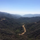
Stoddard Peak Trail courses through the picturesque Barrett Canyon, Cascade Canyon, and Stoddard Canyon, with panoramic views of Mount Baldy (Mount San Antonio). Experience the quaint cottages of the Barrett Cabin area.
On the way to Mount Baldy and within the trail system of the San Gabriel mountain range is the Stoddard Peak Trail. The Stoddard Peak Trail, which is basically the old Barrett-Stoddard fire road, goes through the Stoddard Canyon into Stoddard Flat, and then eventually leads to Stoddard Peak. The Stoddard Peak Trailhead can be accessed by driving on Mount Baldy Road towards Mount Baldy, going through two tunnels, and then turning right on Barrett-Stoddard Road. From Barrett-Stoddard Road, take another right into the small parking lot. Parking in the parking lot is free with the Adventure Pass.
You begin the hike by starting on the dirt trail to the southeast, which is basically Barrett-Stoddard Road. The trail that is south is Old Baldy Road. You will cross a bridge over Baldy Creek within 50 feet of the trailhead. There is a watering hole by the side of the bridge. Many people like to take a swim in the watering hole and pools during the summer months, which is accessible from Old Baldy Road. Continue until you reach a fork in the road. At this point, head left (uphill) to the Barrett Cabin area. Here you will go through a dense oak forest with many creeks and a quaint community of fairy-tale like cabins. At about 0.8 miles you will reach a white metal gate that blocks vehicles from continuing on the road. Go around this gate and continue south. A friendly reminder, do NOT block the road for any reason. There is plenty of parking, but some inconsiderate people insist on parking in the road. Not only does it block the people who live there, but more importantly, it could block fire trucks, which are critical in this area.
Once you hit the 1.25 mile marker, you will be leaving the oak forest and be hiking in open space without shade. You will hike around a ridge and see Cascade Canyon. You will reach another shaded spot temporarily and then be in open space without shade for the remainder of the hike. While hiking during the winter, the shade isn't needed as much. You do have to be careful of patches of ice on the trail, which we encountered while hiking.
At the 2.6 mile marker, you will descend into Stoddard Canyon and reach Stoddard Flat. From Stoddard Flat you can see spectacular views of Mount Baldy and the valley. You can also continue on to hike to Stoddard Peak, time permitting. To do so, look for a pile of rocks to your right. Another 0.4 miles from that point, you will hike on a very narrow and faint trail abundant with brush. You will past two peaks and reach Stoddard Peak. If you wish to not hike to Stoddard Peak, you can turn around and head back the same way you came. Be sure to stop and take some pictures of the beautiful San Gabriel mountain range while you are in the Stoddard Flat area.
Download Outbound mobile app
Find adventures and camping on the go, share photos, use GPX tracks, and download maps for offline use.
Get the appFeatures
Stoddard Peak Trail Reviews
Breathtaking views of the valley, easy hike (we went with a 2 year old and a 4 year old), great mix of shade and sun, forest and mountain. Just one thing : there are quite a lot of small flies on this hike at the end of October.
4.0
Leave No Trace
Always practice Leave No Trace ethics on your adventures and follow local regulations. Please explore responsibly!
Nearby
")
Stoddard Canyon Falls (Baldy Slide Waterfall)

Sunset Peak via South Trailhead

Summit Mt. Baldy

Cedar Glen Camp

Three T’s Trail

Icehouse Saddle via Icehouse Canyon Trail
Discover
Community
Mobile Apps

© 2026 The Outbound Collective - Terms of Use - Privacy Policy