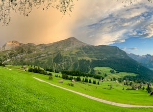
Bettmeralp, Switzerland
Looking for the best hiking in Bettmeralp? We've got you covered with the top trails, trips, hiking, backpacking, camping and more around Bettmeralp. The detailed guides, photos, and reviews are all submitted by the Outbound community.
Top Hiking Spots in and near Bettmeralp
-
Alagna Valsesia, Italy
Hike to Alpe Testanera - Monte Rosa
10.2 mi / 3641.7 ft gainThis is an enjoyable hike that will lead you to a beautiful arena where your can admire the south side of the Monte Rosa.After parking at Wold, after the village of Alagna Valsesia, just follow the road to the Acqua Bianca falls. Here you can find the trail (7a) that leads to Turlo pass and, once...Read more -
Silenen, Switzerland
Hike from Bristen to Sedrun via the Gotthard Tunnel
10.6 mi / 4593.2 ft gainYou start this hike at the Golzern-Talstation in the small town of Bristen in Canton Uri. As it is a point-to-point hike, I recommend to use public transportation. The journey from Amsteg to Bristen is already an adventure by itself: the road is so narrow that other vehicles cannot cross, so that...Read more -
Les Diablerets, Switzerland
Hike and Climb the Via Ferrata de la Cascade
1.5 mi / 500 ft gainA Via Ferrata is a protected climbing road created in the Alps made of steel. With a climber’s kit, you secure yourself to cables periodically attached to the mountain, and climb up with the help of steel pegs fixed into the mountain. The Via Ferrata de la Cascade, which literally translated mea...Read more -
Flüelen, Switzerland
Hike to Surenenpass in the Uri Alps
14 mi / 6000 ft gainThe hike begins in the town of Attinghausen, which can easily be reached by public transport, about 1.5 hours from Zürich. You should follow the yellow signs for the Brüsti Seilbahn. Here, you can take the cable car up to Brüsti (the midpoint between Attinghausen and Surenen Pass) for 10 CHF/$10....Read more -
Erstfeld, Switzerland
Hike Bälmeten
9 mi / 4485 ft gainBrass Tax Distance: 9 mi out and back. Elevation Gain : 4,485 ft Difficulty: Difficult Time: Full day (overnight possibility) The Hike This hike begins in the town of Schattdorf. It is relatively accessible from most major cities by train and bus. You’ll take the cable car up at Schattdorf LS...Read more

