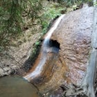
Hike to Nisene Marks' Maple Falls
Aptos, California
Details
Distance
8.5 miles
Elevation Gain
900 ft
Route Type
Out-and-Back
Description
Added by Joshua Scruggs
This hike in Nisene Marks leads through a scenic forest views ending at the falls. Be prepared for several creek crossings.
As you enter the park, you'll need to pay $8 for parking via a self-pay envelope, so it's recommended that you bring exact change. At the park booth, be sure to grab a map. The hike can be a little tricky with no cell service and limited trail signage. Once you've grabbed your map, keep driving past the booth, there are parking areas available further up the road.
During the winter, you'll have to park near the first bridge, but for all other parts of the year, you'll want to park at the George's Picnic Area (36.997309 -121.906507). If you're planning to hike during winter months, be prepared to add a few miles to your hike depending on the parking situation. Add a little extra water and snacks to the pack and make sure you get on the trail a couple hours earlier.
Starting this hike from George's Picnic Area, head out on the Aptos Creek Fire Road for about 1.25 miles until you reach Loma Prieta. Take Loma Preita for 0.7 miles until you reach the Bridge Creek Trail. This trail will take you to the falls in approximately 2 miles.
Make sure you watch your time when starting the hike. Be sure to leave yourself plenty of time before sunset - also, it never hurts to throw a flashlight or headlamp in your backpack just in case.
Here's a brochure of the state park: The Forest of Nisene Marks Brochure
Download the Outbound mobile app
Find adventures and camping on the go, share photos, use GPX tracks, and download maps for offline use.
Get the appFeatures
Hike to Nisene Marks' Maple Falls Reviews
The gate on the fire road is closed during the winter, but the trail is still accessible, adding an extra few miles to a beautiful hike.
5.0
The path there is beautiful and full of bountiful nature, including plants I've never seen, even as a Bay Area native, but oh man it is quite a long hike, or felt long as we felt a bit lost and it was a bit challenging to make sure we were still on track. There are some markers, but not quite enough to be sure of yourself. And, as someone else mentioned, the end of the trail, as you finally get closer to the falls, gets incredibly technical and requires a bit of scrambling on some steep canyon sides and over (or under) logs of various girths (redwoods can get girthy!) I do *not* recommend going during the wet season or immediately after intense rains, as there is one part of the trail that crosses incredibly smooth rock that clearly becomes a waterfall during major rains... one slip and you could possibly fall to canyon area below. Perhaps the trail gets closed during such rains, though. Due to the intense scrambling at the end and being unsure of our path, I can't say it's 5 stars, but I'm happy I went. It was beautiful, there were butterflies flittering around and drinking water when we got there, which made it more magical, but this is definitely a one'r and a done'r. Mission accomplished.
4.0
Bridge Creek trail has a beautiful view all along the way. The last mile is the most technical and challenging to get to the falls as you have to cross the creek several times, walk on logs and get through some steep sections but well worth it!
4.0
Family and friends picked this day hike as a way to kick off the new year. It was a great stroll/hike.
5.0
Amazing hike through Redwoods, several small waterfalls, creek & tree crossings, leading up to the main beauty - Maple Falls! Definitely recommend wearing waterproof shoes with a ton of grip and even ankle support as some parts can be slippery, sandy, and muddy. It took around 4 hours round trip at a mellow pace and so many photo opportunities! Can't wait to go back!
5.0
El Niño has brought a lot of water to California making this hike a must. Maple Falls has more water than I've ever seen in it and the forest is an amazing green.
5.0
Leave No Trace
Always practice Leave No Trace ethics on your adventures and follow local regulations. Please explore responsibly!
Nearby
Bridge Creek Trail to Maple Falls
Land of Medicine Buddha Loop
Camp at New Brighton Campground
New Brighton Beach Trail
Surf the Hook
Surf Pleasure Point
Community
© 2024 The Outbound Collective - Terms of Use - Privacy Policy


