
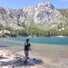
Upper Salmonberry River Trail
Timber, Oregon
Details
Distance
12.52 miles
Elevation Gain
1680 ft
Route Type
Out-and-Back
Description
Added by Jeffrey Green
Hike through unique, abandoned train track scenery, tunnels, and trestles just outside of Timber, Oregon. The trailhead GPS Grid Coordinates are 45°42′16.26″N 123°24′40.58″W.
If you are craving adventure and exploration in a unique hiking setting, then you have come to the right place! This is a hike where every time you turn a corner your eyes light up with excitement and your imagination runs wild. Be forewarned though…if you fear cold, dark, and creepy abandoned train tunnels, this hike is not for you. If you fear extreme heights over abandoned train trestles, this hike is not for you. However, if you're ready to experience a unique hike that leaves a lasting impression, read on!
To get to the trailhead (Located in the Tillamook State Forest) from Portland Oregon, take US 26 west for 36 miles to the Timber Junction and then turn left onto Timber Road. Drive 3 miles to the town of Timber and turn right onto Cochran Road. The pavement will end in a half mile. You’ll pass Reeher’s Camp at 5.5 miles; stay left just after that, then go right at a junction at 6.6 miles. At 9.6 miles, go left onto another unsigned road, then at 9.7 take the far-left road at a three-way intersection. Park at 0.1 mile ahead, just before the road crosses the train tracks. There are no facilities onsite and there is no trailhead fee required.
From the parking area step onto the abandoned train tracks and begin hiking west. Yes, for a very large portion of this hike, you are walking directly on the train tracks that have been abandoned for nearly a decade. The tracks are in complete disrepair and are beautify becoming reclaimed into the earth.
You will have been hiking for about 15-20 minutes through a forested environment when a non-stop sequence of incredible features present themselves one after another!
First up, you’ll need to watch your footing as the train tracks that you're walking on suddenly become suspended high above ground. What's actually occurring is the earth under the tracks is completely washed out, usually from a flooded tributary creek. Be careful, and find a suitable way around the suspended tracks on the high ground.
After a few suspended train tracks, you'll quickly come up on "Tunnel #24". Have your camera ready and more importantly have your flashlight ready! Make your way through the tunnel without being too creeped out. Next up is the "Big Baldwin Train Trestle". Before crossing, look for the really cool abounded water tanker on your left. Next, slowly and cautiously make your way across the trestle. Use extream care while capturing your selfies!
Carrying onward you'll see some more suspended train tracks and now they are getting longer and they're getting suspended higher in the air! You can always find some descent ground to get around them on the high side.
Next up you'll converge on "Tunnel #25". Employ your flashlight once again to safely make your way through. Once on the other side you will go straight onto the impressive curved "Wolf Creek Train Trestle". Once again, use caution and watch your step.
Moving forward you'll once again be walking through a forested scene. You'll be able to see and hear the Upper Salmonberry River downslope to your right. Most hikers conclude this hike at the 5 mile mark designated by a sitting bench and a posted mile marker sign of 804. That's a designation of 804 rail miles from San Francisco. If you continue on for another mile you'll see another pair of smaller tunnels, "#26 and #27". Once you're ready to return, head back the way you hiked in and enjoy all the sights again!
It's very important to note that this unique hike is not an actual trail that is maintained by any agency. The only work it receives is by occasional volunteer work. The train tracks, tunnels, and trestles themselves are private property. They are owned by the Port of Tillamook. The Port of Tillamook recognizes that this is a known hike that experienced hikers use. They allow hiking on their property as a "use at your own risk" policy. Additionally, funding and planning is currently in the works to convert this unofficial user trail into a legitimate State of Oregon hiking trail.
As always, please make sure to practice "leave no trace" principles. Remember to pack all your hiking essentials and to properly layer your clothing during the cold season.
Happy Trails!
Download Outbound mobile app
Find adventures and camping on the go, share photos, use GPX tracks, and download maps for offline use.
Get the appFeatures
Upper Salmonberry River Trail Reviews

If you want info on the status of this trail check here http://salmonberrytrail.org/
3.0
I strongly suggest doing some research on the accessibility of the Salmonberry trail before making the trek out to Tillamook. I arrived on the trail July 2017. Upon my arrival I was disappointed to see a number of signs that said the Salmonberry trail was officially closed and dangerous. The sign continued to say that it would eventually be a trail but at this time hikers that continued on the trail would be prosecuted. I continued on the trail to the west for about .5 miles anyway. The train tracks were covered in overgrowth but I was able to walk along side of the tracks. After .5 miles I gave up and turned around. This seems like an awesome hike looking forward to it opening back up.
1.0

A friend and I went on a rainy Thursday. There wasn't a soul out there but us. There truly is something around every corner! Breathtaking sites, clean woodsy air, creepy tunnels and exciting trestles to cross! We used the gps to get there and it was super easy. The fog came in and made for some great photos.
5.0

This hike is difficult to find, but once you find it, it's worth the effort! Easy, flat hike with tunnels, trestles, and train tracks. It was so quiet when I went (only saw one other person on the trail) and it felt so removed, private, and hidden. It's not often I can go on a hike that feels so untouched. There are a few spots where footing can be tricky (since the tracks are so overgrown) but the entire hike is absolutely gorgeous.
5.0
I enjoyed this hike, it was definitely unique. Fun to explore and take pictures on the bridges. Tunnels are way cool. Had no problem finding the trailhead. However, I give it 4 stars for how busy it was (apparently family day on the railway) and how dirty it was. Trash everywhere!! Dirty diapers, toilet paper, pop bottles, food wrappers and dog poop. Please follow leave no trace principles and stop ruining this otherwise beautiful hike!
4.0
This hike is a hidden gem with very unique photo opportunities. It is very enjoyable that the hike is very flat and not crowded. If you bring a dog be very careful crossing the train trestle.
5.0
Leave No Trace
Always practice Leave No Trace ethics on your adventures and follow local regulations. Please explore responsibly!
Nearby

Storey Burn Loop

Wilson River Trail

University Falls

King's Mountain

Fly Fish the Wilson River in Oregon

Hike the Salmonberry Train Track Trail
Discover
Community
Mobile Apps

© 2026 The Outbound Collective - Terms of Use - Privacy Policy