
Hike to Chimney Top
Cashiers, North Carolina
Details
Distance
1.7 miles
Elevation Gain
1000 ft
Route Type
Out-and-Back
Description
Added by Cody Hager
Scenic Western N.C. hike, just a short drive from the crossroads town of Cashiers. Features amazing views of surrounding mountains including a distinct view of Whiteside Mountain. A hidden gem of a hike nestled behind the High Hampton Inn, just a few miles South on Hwy. 107 from Cashiers.
Upon entering High Hampton Inn, follow the entrance road past the registration building, cart shed and parking lot. Take a right down a gravel road that follows alongside Hampton Lake. This gravel road continues for half a mile, even winding through part of the golf course and crossing over the cart path. The road dead ends at a bridge crossing the headwaters of the Hampton Lake with a cabin across the bridge. There is a small parking place immediately before the bridge. From there, cross the bridge and begin on the Fitness Trail.
The trail is clearly marked, wide, and even has "workout" stations every few hundred feet. The Fitness Trail continues for about a quarter of a mile, then splits to the right, into the Headwater Trail. Follow the Headwater Trail for nearly half of a mile. Along the way you will pass a sign for the Azalea Trail on your right, continue on the Headwater Trail until you come to an intersection of trails.
There will be a sign that points out the different directions of trails. The sign points to the right for Chimney Top and Rock Mountain trails. Follow this trail, which will be marked with blue paint, for another quarter mile. You will arrive at the split for the two trails, Rock Mountain and Chimney Top. The trail for Chimney Top splits to the right and is marked by blue paint.
From here, it is a steep 0.6 miles to the top of the mountain. The trail is well marked, but steep and rocky from this point. At one point along the trail, you will have to climb up a small rock face, so be careful to have a good pair of shoes/boots for traction. Although there are a few views along the way, none are as breathtaking as the view from the summit.
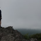
As soon as the trail levels off, you will cross over a large boulder and it will open up to a beautiful clearing looking south-east. From here, you will see a very large, distinct mountain with rock faced cliffs. This is Whiteside Mountain, one of the most popular hikes in the Cashiers/Highlands area. This is one of the best spots to snap any pictures because of the unique view of Whiteside Mountain.
While at the summit, be careful here to stay on the trail, as many of the plants are endangered.
Follow the trail further up the mountain to reach the summit, where a small, round plaque is placed in the rock from the U.S. Forestry Service. Elevation at the summit is 4,618 ft. Rock Mountain, the adjacent mountain and trail, is clearly seen from the summit. This is also a very good spot for photos of Rock Mountain. Be careful of the steep drop-off at the summit and further along the trail. The massive drop can be deceiving. Make sure to keep all pets and children close by.
If you continue along the trail just a bit further, you'll reach the very end with another view looking back towards Cashiers/Sapphire. Old Bald and Fairview Lake are visible as well as the Sapphire golf course. Be very careful at these cliffs as the drop-off is once again, very steep.
Simply retrace your steps to make it back to your car and as always, please respect the beautiful environment by staying on the trail and picking up after yourself.
Download Outbound mobile app
Find adventures and camping on the go, share photos, use GPX tracks, and download maps for offline use.
Get the appFeatures
Hike to Chimney Top Reviews

The a high Hampton Inn has closed it’s property to non-guests. I don’t think there is another access to Chimney Top, Cashiers, NC
1.0

Great terrain variety with big view at the top.
5.0
Leave No Trace
Always practice Leave No Trace ethics on your adventures and follow local regulations. Please explore responsibly!
Nearby

Hike to Silver Run Falls

Explore Cashiers Sliding Rock

Hike the Whiteside Mountain Loop

John's Jump Falls and DEW Falls

Hike to Blackrock Overlook

Hike to Granny Burrell Falls
Discover
Community
Mobile Apps

© 2026 The Outbound Collective - Terms of Use - Privacy Policy