
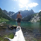

Camp at Lower Lake
Alberni-Clayoquot C, British Columbia
4.0
2.5 mi
/ 1640.4 ft gain
Lower Lake is a gorgeous alpine lake located on the Triple Peak Trail. The route to the lake is very steep and scrambling is involved, but is well worth the effort. When you come to the rise above the final ridge, the stunning Triple Peak and Lower Lake come into view.The hike starts down a very steep, root-filled forest trail and opens up to the smooth flowing Marion Creek. After crossing the ...

Exploring Myra Falls
Comox-Strathcona D, British Columbia
5.0
0.6 mi
These beautiful falls are just a short and easy 500 metre stroll from the parking lot, making this one of the more family-friendly hikes in the area. Located at the end of the trail are the 75 metre cascading falls and spectacular views of Buttle Lake.Located approximately 1 1/2 hours north of the Comox Valley, the trailhead starts at the south end of Buttle Lake along the Westmin Road. At the ...

Camp at San Josef Bay
Mount Waddington B, British Columbia
3.7 mi
/ 328.1 ft gain
This trek allows for easy access to an incredibly picturesque, white sandy beach. The trail meanders through the lush Pacific Northwest forest for most of the trip and then follows along a beach for the last part, ending at the camping areas.The hike begins at the Cape Scott Provincial Park parking lot and follows a well-used path for 900 meters, then takes a left turn before heading toward the...

Mt. Myra via Tennent Lake Trail
Comox-Strathcona D, British Columbia
9.33 mi
/ 4810 ft gain
Very few people know about this hidden gem which makes it less crowded and all the more special. The views and serenity that this place possess are what will really draw you in.
The hike starts at the Westmin Mine parking lot, located 2 hours north of Courtenay. To find the start of the trailhead you will need to walk southwest for 1.2km from the parking lot along Tennant Road (gravel) to the ...

Camp at Arnica Lake
Comox-Strathcona D, British Columbia
7.5 mi
/ 2624.7 ft gain
The hike starts at the Westmin mine parking lot, located 2 hours north of Courtenay. To find the start of the trail you need to walk 50 metres down a dirt road from the parking area. You will see a sign for Phillips ridge, which marks the start of your journey.The trail starts in a relatively flat area, which is packed tight with trees. After about 20 minutes, the trail becomes steeper and tur...
Community
Mobile Apps

© 2024 The Outbound Collective - Terms of Use - Privacy Policy