
Hike West Spanish Peak
Aguilar, Colorado
Details
Distance
7.2 miles
Elevation Gain
2.38 ft
Route Type
Out-and-Back
Description
Added by Antonin Ivanov
Though only 13,626 ft. Elev. the West Spanish Peak is the most prominent point in the southern Colorado region. The peak can be seen for miles and the view from this hidden gem of mountaineering is well worth the intense 1/4 mile scramble to the summit. Be wary of thunderstorms however, it is known for lightning activity.
The West Spanish Peak is best reached by way of CO Hwy 12, which connects south and west through the town of La Veta, Colorado. From Denver travel I-25 south to Walsenburg (about 3.5 hours). At Walsenburg take US 160 to CO 12 southwest through the towns of La Veta and Cuchara.
Cordova Pass Trailhead (11,248 ft): Follow the directions above. Continue past Cuchara 6.25 miles to Cucharas Pass. Once at Cucharas Pass look for the signed turnoff for FSR 415 to Cordova Pass. Continue 6 miles to Cordova Pass.
This trailhead is a fee area.
Day use parking is $6.00 (2017) unless the lot is full and you park at a campsite in which case you will have to pay the $6.00 camping fee.
Pay on arrival (they'll snag you for it) at the fee box near the restroom facility.
A list of regulations are also located at the fee station.
The West Peak Trail has a sign-in station a short distance inside the trailhead.
When to climb:
Due to the easy, close access of the peak from Cordova Pass, climbing West Spanish Peak can be done anytime Cordova Pass can be reached. This has been done as early as April and as late as Thanksgiving.
Summer can be tricky due to the thunderstorms that quickly develop, particularly in July and August. Start early in the morning and plan to be off the summit around noon or shortly after. Keep your ears tuned for thunder!
Late May through mid-July offers very early morning starts. September and October offer good opportunities since the storm season is over by then.
Cool clear mornings make for great hiking. Fall also offers changing aspen tree colors and a decrease in human activity in the area.
My adventure:
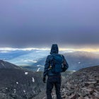
Getting to the trailhead a bit later than usual, my brother and I began the ascent around 9am. We climbed in mid-July and found it (Though a bit dry) to be very pleasant. This trail is virtually unknown and we only encountered one other hiker for the entirety.
We were used to hiking in the summer, and the first 2.5 miles of the trail are very easy, so we made good time. You might be able to see in the photos and on a Topo map that the last 0.5 mile are killer. It would definitely be a beginner rating, but for that ridgeline. After a slight incline in a wooded area, the trail abruptly goes straight up the ridge. If you can handle a little shale scrambling, the views from the top are phenomenal. We made it from beginning to summit, in about 30min. But this was at a brisk pace and with a well acclimated lung capacity. I would put a rough estimate of normal at 45-60min.
We remained at the top for a good bit, enjoying the sun and view. After a while however a storm looked to be brewing and it is an extremely bad idea to be on this peak with even a hint of lightning. Accordingly we began the descent, making it back to the trailhead in 20min. (Running) all in all, we got great photos and got a good little hike in. Well worth the sore quads the next day from all the shale trekking.
Download Outbound mobile app
Find adventures and camping on the go, share photos, use GPX tracks, and download maps for offline use.
Get the appFeatures
Hike West Spanish Peak Reviews
Jesse, I’m not sure if you are not as accomplished as you think you are, or you are just used to slow trekking, but I feel as though it was clear that we are experienced mountaineers and traveled at a brisk rate, to accomplish this summit in 30min and though it may be dangerous to some to run down, for us it was normal. I appreciate your review and I possibly should have extended the timeframes for less experienced climbers, (as many beginners claim to be experienced) but the facts and times that are in the description are accurate to my adventure.
5.0

I did this hike yesterday and it was fantastic. had I trusted this description, however, I certainly would not have made it to the top before thunderstorms would roll in as they always do in the summer here. First of all, the only way to make it from the trailhead to the summit in 30 minutes, as described above, would be by helicopter. I am a fairly experienced outdoorsman and capable hiker here in Colorado, and just getting to treeline took over an hour. After that, safely scrambling up the talus field to the summit took another 2 hours. Secondly, climbing down the rock slide took longer than climbing up...you would surely die if you attempted to run down this "almost 14er". I don't know if you were thinking about a different hike when you wrote this, or if you were just stoking your ego, either way post like this could get someone hurt. save the over embellishments for Facebook, and stick to the honest facts on an app or site such as this.
5.0
Leave No Trace
Always practice Leave No Trace ethics on your adventures and follow local regulations. Please explore responsibly!
Nearby

Camp at Bear Lake

Horseshoe Lake
")
Mount Lindsey (CLOSED)

Summit Little Bear Peak

Summit Blanca and Ellingwood Peaks

Zapata Falls
Discover
Community
Mobile Apps

© 2026 The Outbound Collective - Terms of Use - Privacy Policy