
Hike Grizzly Peak at Loveland Pass
Dillon, Colorado
Details
Distance
6 miles
Elevation Gain
2900 ft
Route Type
Out-and-Back
Description
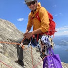
Added by Amy Kesic
2900’ elevation gain. 6+ miles round-trip. Continental Divide hike above tree line. Amazing 360-degree views. A physically demanding climb. Accessible year-round.
While a typical Colorado hike may be an ascent to your destination followed by a descent back to your car, the hike to Grizzly Peak at Loveland Pass (Grizzly Peak "D") breaks that mold. At 13,427 feet, Grizzly Peak stands in the path to Torreys Peak’s west face (14,267’). Even though it is only ~1440’ above the trailhead, the hike includes 2900’ total elevation gain, out and back.
This hike begins at the Loveland Pass summit – 11,990 feet – which means throughout the duration, you have incredible 360-degree views for miles. From this trail you can see three ski areas at once: Arapahoe Basin, Keystone, and Breckenridge. While this makes a good summer wildflower hike, it is actually more popular with winter hikers and backcountry skiers. Having done two sunrise hikes here, I highly recommend starting at dawn; the alpenglow on the surrounding snow-capped peaks is just stunning!
The hike starts off challenging and only gets better from there. It is riddled with a number of “false summits,” which are actually mountains in their own right. The first mile to Pt. 12,915 is a 900’ ascent, giving you the most altitude gain at one time. You’ll see two wind shelters at this low summit, and from there, the trail forks to the north and to the east. North goes to Mount Sniktau, a nice and easy 13er. East passes over "Cupid" to Grizzly Peak (and eventually Torreys Peak, should you choose to go that far).
(Note: About .5 mile up from the trailhead, there is a cairn that marks a bypass trail heading directly toward “Cupid.” Both routes have their pros and cons. The bypass trail does bypass the first false summit, but it is overall steeper and narrower with more exposure. I took the standard trail up and the bypass trail back.)
Continuing east, you’ll follow the ridge, which dips into a saddle and then a gentle climb to summit the 13er “Cupid” (13,117’). If you are a peak bagger, go off the trail a short ways to climb atop the rocks there. On the descent, there is a large pile of rocks directly ahead. You can go over them or around them, it’s up to you. I went over them, but my small dog struggled with it. After reaching the saddle, you’ll then ascend a smaller false summit of 12,936 feet. Dip down again, and you’re ready to face The Grizz.
It’s an intimidating view. I admit, the first time I was faced with Grizzly’s steep incline, I turned around and went home. I just wasn’t prepared for it. But I was determined to go back and do it with better preparation, and I did. Personally, I feel if you want to do this mountain, you have to go into it committed from the start, and prepared both physically and mentally. That means plenty of water and fuel, all the weather-appropriate gear, and a certain fitness level. According to my GPS, it’s a 650’ climb from the bottom of the saddle to the summit, in about 0.3 mile.
I climbed this peak in mid-October, which meant the trail went “missing” at times due to snow. The best thing to do is follow in others’ footsteps, if possible. The one time I did not, I found myself on some fast-sliding scree…scary. The climb is a Class 2 scramble at times, meaning you’ll need to use your hands to help navigate. While it is not technically very difficult, it is physically demanding.
The view from the top of Grizzly Peak is phenomenal. Torreys Peak, that massive mountain of majesty, feels like it’s close enough to touch. I would have loved to continue on and summit Torreys as well, but looking down into the deep saddle between the two mountains, well … that’ll have to be another day. (It’s an additional 3 miles and 2400’ ascent round-trip.) To the south is Chihuahua Gulch, now on next summer’s must-do list. In all directions, it’s peaks as far as the eye can see—the Mosquito Range, the Gore Range, the Tenmile Range, and of course, the Front Range.
In my opinion, it’s the return trip that makes this hike such a mental challenge. After conquering three smaller summits and the bear of a climb to Grizzly Peak, you now get to turn around and crest all those summits once again. And “Cupid” is a steeper climb on the return than it was the first time around. By the time you’re in that last saddle looking up at that last 12,915-footer, you just might start to feel a little annoyed (if you’re like me). Finally, you’re on that last 900’ descent toward your car on quivering legs, feeling a little smug at all the fresh faces toiling up the trail.
After reading a variety of accounts online, reactions of this hike vary from “easy trail run” to—like me—a bear of a hike. It all depends on your level of fitness and experience, I suppose. I did this hike in 4 hours, 15 minutes, which is probably about average. There does seem to be a consensus, however, that it is a rewarding and beautiful hike. The number one concern is the weather. It is almost perpetually windy, and sudden storms (both summer and winter) are frequent and to be taken seriously. It’s not a casual day hike, so before attempting it, be sure to do your research and come prepared for possible adverse conditions.
Also: No bathrooms, and no place to hide.
Download the Outbound mobile app
Find adventures and camping on the go, share photos, use GPX tracks, and download maps for offline use.
Get the appFeatures
Hike Grizzly Peak at Loveland Pass Reviews
This is a great hike at altitude and can be done in the winter close to just as easily. Great views of nearby 14er's and the towns below make this a great outing. If you are doing this in the winter, an axe might be advisable depending on the snow coverage. Ice spikes also could give you some extra peace of mind on the final push to the summit.
5.0
Amy nailed it! There are so many ups and downs, and with each one a new view and perspective. The last saddle before climbing Grizzly seemed steeper and deeper than the others. I was lucky enough to have perfectly clear weather for the day, but I could see the danger of being on an exposed ridge for so long. Some fun scrambling over the rock pile. I was spent when it was over but I was sorry it was over.
5.0
Leave No Trace
Always practice Leave No Trace ethics on your adventures and follow local regulations. Please explore responsibly!
Nearby

Hiking Mount Sniktau

Photograph the Milky Way at Loveland Pass

Backcountry Snowshoe and Ski Paradise

Wildflowers, Lakes, and Peaks, Oh My!

Snowshoe or Ski Watrous Gulch

Bakerville Scenic Snowshoe/XC Ski Trek
Community
Mobile Apps

© 2024 The Outbound Collective - Terms of Use - Privacy Policy