
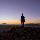
Summit Castle Peak
Soda Springs, California
Details
Distance
6 miles
Elevation Gain
1800 ft
Route Type
Out-and-Back
Description
Added by Mike Fennell
The tallest mountain in the Tahoe Donner area, Castle Peak is easy enough to conquer in a few hours while rewarding you with stunning 360 degree views
The trailhead is very easy to access as it is just off Highway 80 at the Boreal Mountain exit. When taking the exit, take a turn to the North, rather than to Boreal on the South side of the Highway.
On busy summer weekends this trailhead can get quite crowded so you may have to park at the bottom of the road less than 100 yards from the Highway 80 off-ramp. The first mile of the trail is actually a forest road and you can take your 4x4 further up if looking to shorten your hike or even car camp in the National Forest.
From the trailhead to the Peak is about 3 miles and the trail is well maintained so easy to follow. The first couple of miles head Northwest on a gradual slope until you reach Castle Pass, which junctions with the Pacific Crest Trail. Once on top of this pass, follow the Castle Peak ridgeline to the Northeast. After about a half mile along the scenic ridge the trail will become steep as it wraps around the northern slope of the mountain until you reach the actual peak. It's pretty obvious to follow since the south face of the mountain is made of sheer rock cliffs. Be careful of loose rocks when reaching the summit.
Download Outbound mobile app
Find adventures and camping on the go, share photos, use GPX tracks, and download maps for offline use.
Get the appFeatures
Summit Castle Peak Reviews
- The overview is pretty spot on. If you park at the bottom (where the pavement ends) be sure to stay right at the immediate fork, then left at the next to keep on the main road. On our visit 4x4 wouldn’t have been necessary but the road was potholed/rutted so clearance would have been. From here it’s a steady incline up the road to start. If you drive to the base of Castle Pass it’s quite a bit shorter and you’ll jump right into to the main climb of the hike. It’s steep, dusty, and rocky so choose appropriate footwear. If you’ve got time, extend the trip and hike out to Basin Peak too.
3.0
I thought it would be a lot harder seeing as this hike is rated advanced. I personally thing it should be rated at moderate. So beautiful up there lots of dogs:)
5.0
Leave No Trace
Always practice Leave No Trace ethics on your adventures and follow local regulations. Please explore responsibly!
Nearby

Andesite Peak via Hole in the Ground Trail

Snowshoe to the Peter Grubb Hut

Hike to the Peter Benson Hut
")
Truckee Tunnels (Donner Tunnel Trails)

Donner Lake Rim Trail: Johnson Canyon to Trout Creek

Donner Lake Public Docks
Discover
Community
Mobile Apps

© 2026 The Outbound Collective - Terms of Use - Privacy Policy