

Walk the Stations of the Cross At Holy Hill
Hubertus, Wisconsin
5.0
1.3 mi
/ 450 ft gain
Holy Hill National Shrine is a landmark within the Wisconsin area, both as a tourist spot and a great location for fall colors. Located outside of Hubertus, WI, it is east of the Kettle Moraine Scene Drive and Cty Rd 167 intersection. Once arriving, there are three parking locations: the top of the hill next to the basilica, the parking lot at the bottom of the hill, or the secondary parking lo...

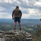
Visit the Parnell Observation Tower
Adell, Wisconsin
4.0
0.5 mi
/ 200 ft gain
Located southwest of Plymouth, WI, the Parnell Observation Tower is located just west of the intersection of Cty Road A and Cty Road U. At the trail-head, the parking lot has a restroom facility, drinking water, and a picnic area.The start of the trail has well established wooden steps along the entire walk to the base of the tower. On your left, there is an alternative route to begin the Parne...

Hike the Thordarson Loop Trail at Rock Island State Park
Washington, Wisconsin
5.2 mi
Getting to Rock Island is the first part of the journey. Driving to the tip of Door County, drive to the Northport Pier and grab your first ferry to Washington Island. Once there, drive across the island to Kafri Ferry dock. This ferry does not allow vehicles, so you'll be carrying anything you'll want to bring to the island. There are carts available for rent, and are easy to use for the close...

Backpack the CDT Loop in Rocky Mountain NP
Grand Lake, Colorado
24.3 mi
/ 4000 ft gain
This section of the CDT begins at the North Inlet trailhead, located on the western side of Rocky Mountain National Park. The trailhead is north of the main town area of Grand Lake. Parking at the trailhead is limited, so hikers can also park along the road leading to the trailhead. The hike follows the same route as the trip towards Cascade Falls (Hike to Cascade Falls, Rocky Mountain NP). Aft...

Sable Falls
Grand Marais, Michigan
5.0
0.25 mi
/ 43 ft gain
Located off of H-58, Sable Falls can be found about a mile north of the eastern terminus of Pictured Rocks and the Grand Sable Visitors Center. There is a large parking lot area for the falls, along with an entrance onto the North Country Trail, which runs along the falls. The hike is short, with stairs leading towards the falls. The trail continues along the creek to Sable Beach, and east to c...

Tannery Falls
Munising, Michigan
0.37 mi
/ 112 ft gain
Located right off of County Highway 58 across from Sand Point Road, Tannery Falls doesn't see the larger advertising that many other falls see in the area, but is a hidden gem within the town. At the start of the hike, you'll need to find a parking spot off of the highway, you might run into ticketing parking there. Once done, you can see the stairway for the trail. The trail is short, running ...

Mirror Lake Cabins Loop
Ontonagon, Michigan
6.24 mi
/ 584 ft gain
The trip to Mirror Lake begins at the Summit Peak Scenic Area. To extend your hike, start at the Lily Pond trail-head farther south on Summit Peak Road (5.3 miles to cabin). The initial trail towards the lake is the Beaver Creek trail (1.2 miles). The trail climbs down the peak slope into some lower valley and towards the Little Carp River. The trail was well managed and fairly dry, with select...
Discover
Community
Mobile Apps

© 2026 The Outbound Collective - Terms of Use - Privacy Policy