Ronald, Washington
Looking for the best photography in Ronald? We've got you covered with the top trails, trips, hiking, backpacking, camping and more around Ronald. The detailed guides, photos, and reviews are all submitted by the Outbound community.
Top Photography Spots in and near Ronald
-
North Bend, Washington
Gem Lake, WA
4.710.4 mi / 2923 ft gainThis hike shares the trailhead for Snow lake at the Alpental Ski area in Snoqualmie Pass. You'll start out with a great warm up, walking through dense green underbrush and a brief wooded area. Before too long the trail increases in inclination slightly and begins to offer up some small rocky sect...Read more -
North Bend, Washington
Snow Lake
4.06.24 mi / 1699 ft gainThis hike gets crowded fairly quickly so get there early. The parking lot is very large so parking is not really a problem. There are bathrooms at the very beginning of the trail so I highly suggest using them. However at the top there is also a designated restroom area. Starting at 2600 ft, thi...Read more -
North Bend, Washington
Annette Lake
4.57.2 mi / 1923 ft gainFrom Seattle drive east on I-90 to exit 47 (Asahel Curtis/Denny Creek). Turn right from the off-ramp and continue 0.25 mile, then turn left on Forest Road 5590. You'll find the parking area in 0.3 mile. Between the thick second-growth forest stands and the high alpine lake, the trail rolls along...Read more -
North Bend, Washington
Ski or Snowshoe to Pineapple Pass
3.04.5 mi / 2000 ft gainSkiers or snowshoers looking to explore this route should park in the uppermost parking area at the Alpental ski area. This lot is past the main parking lot for the ski area. After getting your gear on, you can proceed down the groomed access run heading northwest out of the parking area. This ru...Read more -
North Bend, Washington
Granite Mountain
4.27.92 mi / 3999 ft gainThe trek up Granite Mountain is a strenuous and fairly steep hike located east of Seattle and west of Snoqualmie pass off of I-90. Take exit 47 and turn North to a T intersection, park at the Pratt lake Trailhead at approximately 1860' and right beside I-90. The trail splits just after the first...Read more -
North Bend, Washington
Overnight Hike to Pratt Lake
4.511 mi / 2300 ft gainThis overnight hike is definitely a challenge with 2,300 feet of elevation gain but all that huffing and puffing will be worth it when you reach the beautiful Pratt Lake Basin.The trail can be a bit busy in the first mile but most of the traffic is from day hikers on their way up the popular Gran...Read more -
Leavenworth, Washington
Winter Camping in Leavenworth
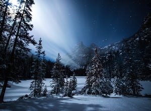
It's an easy day hike to the Ridge of only 2.5 miles. On the ridge you can relax and enjoy the view of the surrounding mountains and a view of Leavenworth. I went into the Rangers office to ask for a good spot to take night time photos and this is one of the areas they suggested. Make sure you ge...Read more -
Leavenworth, Washington
The Enchantments: Leprechaun Lake via Snow Lake Trailhead
4.719.57 mi / 5948 ft gainThe Alpine Lakes Wilderness named “The Enchantments” draws explorers from all over the world. On a four day backpacking trip you can take day trips from camp to explore over a dozen crystal clear lakes, summit surrounding peaks, and camp at an alpine lake of your choice! Before you set out to c...Read more -
Leavenworth, Washington
The Enchantments Mountain Run
5.018 mi / 6000 ft gainAt the Snow Lake Trail, you start at a elevation of 1400 feet and run up to Nada Lake 5000 feet at 5.6 miles. From here, you make your way to Lower and Upper Snow Lake, 2.2 miles. There are a lot of campsites in this area, but you have to apply to stay the night at these lakes. You will need to...Read more -
Leavenworth, Washington
Winter Camp at Nada Lake
10.6 mi / 3800 ft gainBeing one of the lucky recipients of an Enchantments overnight permit can't happen for everybody. So, for the rest of us, taking to the mountains in the winter is an awesome way to bypass this system and experience the central Cascades in a completely different, colder way. The suffering is almos...Read more -
Leavenworth, Washington
Climb Prusik Peak's West Ridge
18 mi / 5000 ft gainThe Enchantments are an amazing experience in themselves. Yet one of the most striking features of any hike into the core zone of the Enchantments is that of Prusik Peak. This pyramid like spire rises dramatically from the many puddle lakes and boulder fields you pass along your way. With it's...Read more -
Leavenworth, Washington
Hike Fourth of July Creek to Icicle Ridge
12 mi / 4800 ft gainMost adventurers travel down Icicle Creek Road to visit Colchuck Lake and the Enchantment Basin. But, if you're looking for an adventure for a cool summer morning without the crowds, continue past the Colchuck/Stuart forest road and explore this trail! Expansive views of the entire Stuart range...Read more -
Enumclaw, Washington
Snowshoe to Sun Top Peak
12 mi / 2000 ft gainFrom Tacoma, Wa. take Hwy 167 to Hwy 410 and follow that until you get to the Chinook Pass Hwy. Then from there follow this road and take the second Service Road on the right and follow this road until it dead ends. The trail starts on NF-7315. You have to walk this road until you reach the first...Read more -
North Bend, Washington
McClellan Butte
5.010.61 mi / 3629 ft gainStarting at the McClellan's Butte Trailhead, right off of I-90 exit 47, head out on the main (only) trail at the trailhad. The first half mile of the trail is quite easy as it meanders through the forest, but don't be fooled or worried, it will get harder. This first half mile has a crossing of a...Read more -
North Bend, Washington
Summit Mt. Defiance
5.011 mi / 3300 ft gainThis hike offers some of the best views one can see in the area. On a clear day, you'll get amazing views of Mt. Rainier. The best part is that as you start heading uphill in the first half mile, you'll get great views of McClellan Butte. Once you reach the summit of Defiance at 5584 feet, you'll...Read more -
North Bend, Washington
Bandera Mountain
4.47.8 mi / 3176 ft gainThis hike has unreal views of Mount Rainier. On a great clear spring day, the mountain is out. It's right in your face. It's incredible. If you tackle this hike in the spring the bear grass and wildflowers are alive and blooming towards the top and it makes for some fantastic picture-taking. Once...Read more

